| WPC Met Watch |
|
|
Mesoscale Precipitation Discussion: #0878 (2019) |
|
(Issued at 910 PM EDT Sat Sep 21 2019
) |
|
| MPD Selection |
|
|
|
|
|

Mesoscale Precipitation Discussion 0878
NWS Weather Prediction Center College Park MD
910 PM EDT Sat Sep 21 2019

Areas affected...Central to Northeast KS...Southeast
NE...Southwest IA...Northwest MO

Concerning...Heavy rainfall...Flash flooding likely

Valid 220110Z - 220710Z

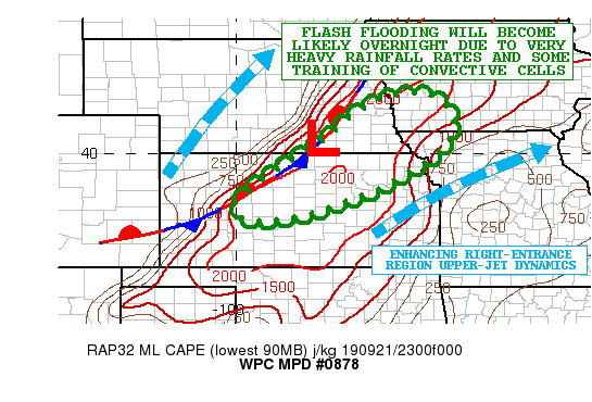
SUMMARY...An axis of showers and thunderstorms is expected to grow
upscale overnight and gradually shift off to the east. Heavy
rainfall rates and some periodic training of cells is expected to
result in an heightened risk of flash flooding.

DISCUSSION...The latest radar imagery shows and an axis of heavy
showers and thunderstorms quickly developing and expanding in
coverage across areas of central KS to southeast NE, with the
activity focusing along and just ahead of a quasi-stationary front.

The warm-sector airmass pooled along and east of the front is very
unstable with MLCAPE values of as much as 3000+ j/kg. Meanwhile,
the moisture across the broader central Plains region is rather
anomalous with PWATs of over 1.75 inches, which is a solid 2+
standard deviations above normal. In part, the anomalous
atmospheric moisture profiles are being facilitated by a
well-defined mid to upper level eastern tropical Pacific moisture
fetch which is largely being driven by deep layer southwest flow
emanating away from Tropical Storm Lorena situated over the Gulf
of California. This is depicted rather clearly in the latest
700/300 mb CIRA-LPW data analysis.

Meanwhile, the latest GOES-16 WV suite shows a well-defined
shortwave trough over the central Rockies which is advancing east
through the base of a larger scale trough ejecting east across the
central/northern Plains region. This energy will be facilitating
an uptick in larger scale forcing overnight across central to
northeast KS, southeast NE, southwest IA and eventually northwest
MO as favorable right-entrance region upper-jet dynamics set up
and interact with the very favorable warm-sector thermodynamic
environment along and east of the cold front.

The 18Z HREF suite of guidance is somewhat unclear on where the
heaviest rainfall potential will set up in the short-term, and if
anything, may be a bit underdone across areas of central KS to
southeast NE where convection is already beginning to train over
the same area. The concern for training convection given deep
layer southwest flow running nearly parallel to the front will
drive a locally enhanced rainfall threat, but later in the night
the convection should begin to advance farther east as the
shortwave energy and front begins to edge farther east. Moisture
and instability will remain plentiful throughout the night and
strongly aided by a southwest low-level jet of 40 to 50 kts, and
this should drive efficient convection with very heavy rainfall
rates of 2 to 2.5 inches/hr going through 06Z and beyond.

Expect rainfall amounts of as much as 3 to 5 inches with isolated
heavier amounts where the more prolonged areas of training
convection set up. This will likely drive some areas of flash
flooding. Initially, the the threat will be central KS to
southeast NE, but areas of southwest IA and northwest MO will see
the convective threat increase toward and after 06Z.

Orrison

ATTN...WFO...DDC...DMX...EAX...GID...ICT...OAX...TOP...

ATTN...RFC...ABRFC...MBRFC...

LAT...LON   41559501 41139437 40539432 39969477 39009647
            38379835 38289968 38710000 39499902 40269782
            41009695 41469607
Last Updated: 909 PM EDT Sat Sep 21 2019
|


