| WPC Met Watch |
|
|
Mesoscale Precipitation Discussion: #0890 (2023) |
|
(Issued at 825 AM EDT Tue Aug 08 2023
) |
|
| MPD Selection |
|
|
|
|
|

Mesoscale Precipitation Discussion 0890
NWS Weather Prediction Center College Park MD
825 AM EDT Tue Aug 08 2023

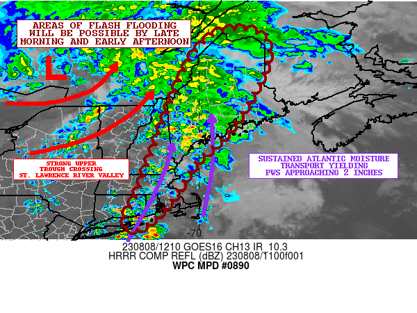
Areas affected...Portions of New England

Concerning...Heavy rainfall...Flash flooding possible

Valid 081225Z - 081825Z

SUMMARY...Repeating rounds of heavy shower activity are expected
to drive a threat for some instances of flash flooding going
through the early afternoon hours.

DISCUSSION...A rather strong upper-level trough is lifting up
across the St. Lawrence River Valley early this morning which is
driving rather strong warm air advection up across New England and
is facilitating the poleward advance of tropical moisture up along
the East Coast and in off the Atlantic Ocean.

This coupled with a nose of at least modest instability with
MUCAPE values of 500 to 750 J/kg will be driving multiple rounds
of heavy shower activity going through the morning hours, and the
latest radar imagery does show a broken axis of heavy showers
stretching from portions of eastern CT and eastern MA up through
eastern NH and into large areas of central and southern ME.

PWs across the region are anomalously high with values of 1.75 to
2 inches, and there are some suggestions in GOES-E IR satellite
imagery of warm-topped convection producing highly efficient and
heavy rainfall rates. Some of these rates are locally as high as 1
to 1.5 inches/hour.

There are some concerning signals coming out of the last several
runs of the HRRR guidance which suggest a well-defined axis of
repeating/training convection across areas of central and southern
ME going through the midday hours, with enhanced rainfall rates
that may increase to as much as 2 inches/hour. Driving this threat
will be somewhat stronger forcing arriving across the region in
association with left-exit region upper-jet dynamics around the
southeast flank of the upper trough. A strong low-level jet is
also forecast to be reaching as high as 40 to 50 kts out of the
southeast which will maintain strong Atlantic moisture transport
and will be aiding stronger low-level convergence and orographic
ascent.

The remaining HREF solutions from the 06Z cycle are generally not
as aggressive as the recent HRRR runs, but nevertheless are
supportive of locally organized heavy rainfall potential going
through the late morning and early afternoon hours. The
environment should be conducive for seeing repeating and/or
training bands of convection, and based on this, rainfall totals
of as much as 3 to 4 inches may be possible going through the
early afternoon hours. The heaviest rainfall should tend to be
over central and southern ME, but adjacent areas of New England
will also be seeing locally a couple inches of rainfall potential.

Areas of flash flooding will be possible by later this morning and
early this afternoon as these heavier rainfall totals materialize.

Orrison

ATTN...WFO...BOX...CAR...GYX...OKX...

ATTN...RFC...NERFC...NWC...

LAT...LON   47506928 47486808 46896767 45976793 44916851
            43896927 43137013 42027083 40967185 40917239
            41267248 41897212 43617148 45527074 46727015
Last Updated: 825 AM EDT Tue Aug 08 2023
|


