| WPC Met Watch |
|
|
Mesoscale Precipitation Discussion: #0898 (2024) |
|
(Issued at 111 PM EDT Sun Aug 18 2024
) |
|
| MPD Selection |
|
|
|
|
|

Mesoscale Precipitation Discussion 0898
NWS Weather Prediction Center College Park MD
111 PM EDT Sun Aug 18 2024

Areas affected...Mid-Atlantic States from southern Upstate NY
through central MD

Concerning...Heavy rainfall...Flash flooding possible

Valid 181710Z - 182300Z

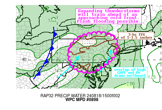
Summary...Showers and thunderstorms will expand ahead of a cold
front through this evening. These thunderstorms will train to the
northeast with rain rates of 1-2"/hr or more. This will produce
2-4" of rain and possible flash flooding.

Discussion...The regional radar mosaic this afternoon shows a
rapid expansion of reflectivity along a pre-frontal trough ahead
of a cold front. This cold front will move out of the Ohio Valley
and into the Mid-Atlantic the next few hours, to combine with
increasing upper diffluence in the LFQ of a poleward arcing jet
streak, robust height falls as a longwave trough axis pivots
eastward, and subtle embedded shortwaves to produce impressive
deep layer ascent. This lift will impinge into intensifying
thermodynamics characterized by PWs of 1.5 to 1.7 inches, and
MLCAPE above 1000 J/kg to support the expanding and intensifying
convection. Recent radar-estimated rainfall rates have exceeded
1"/hr in the stronger updrafts, and these will likely continue to
intensify through the afternoon.

The high-res CAMs are in good agreement that showers and
thunderstorms will become widespread across PA and also extend
into MD and and NJ by this evening. While the exact placement of
storms varies, there will likely be multiple clusters moving SW to
NE on 0-6km mean winds of 15-20kts. This will keep storms
generally progressive, but Corfidi vectors aligned to the mean
wind and becoming increasingly parallel to the front/pre-frontal
trough suggests an enhanced training potential. Additionally, a
bubble of locally enhanced bulk shear reaching 20-25 kts across
the eastern Mid-Atlantic states could help organize cells as well.
Together, this provides support for the HREF neighborhood
probabilities which reach 20-40% for 2"/hr rates by this evening,
which through training could produce 2-4" of rain with locally
higher amounts. The CAMs generally focus the heaviest rain between
I-95 and I-81, where the HREF PMM in the next 6 hours shows
locally as much as 5 inches of rain is possible.

Training of these intense rain rates have the potential to produce
flash flooding, especially across urban areas. However, some of
this region has also been quite wet as reflected by AHPS 7-day
rainfall as much as 600% of normal. This has lead to extremely
compromised FFG of 1-1.5"/3hrs for which the HREF exceedance
probabilities reach as high as 60%. Anywhere these rates train
could cause instances of flash flooding, but it will be most
likely across urban areas or atop these more vulnerable and
pre-conditioned soils.


Weiss

ATTN...WFO...ALY...BGM...BUF...CTP...LWX...OKX...PHI...

ATTN...RFC...MARFC...NERFC...OHRFC...NWC...

LAT...LON   42487606 42337496 42017447 41347434 40777443
            40247470 39757529 39277595 38907676 38917706
            38967750 39067787 39257823 39537850 39977867
            40307876 41357857 42157758
Download in GIS format: Shapefile
| KML
Last Updated: 111 PM EDT Sun Aug 18 2024
|


