| WPC Met Watch |
|
|
Mesoscale Precipitation Discussion: #0953 (2022) |
|
(Issued at 557 PM EDT Mon Sep 05 2022
) |
|
| MPD Selection |
|
|
|
|
|

Mesoscale Precipitation Discussion 0953
NWS Weather Prediction Center College Park MD
557 PM EDT Mon Sep 05 2022

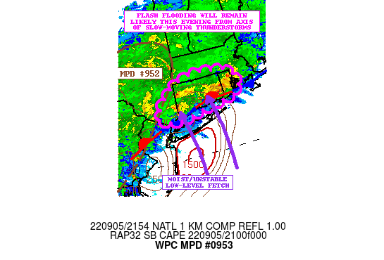
Areas affected...Far Southeast New York and Southern New England

Concerning...Heavy rainfall...Flash flooding likely

Valid 052156Z - 060156Z

SUMMARY...Areas of extremely heavy showers and thunderstorms are
expected to continue impacting areas of southern New England
involving Connecticut and Rhode Island this evening. The threat
may expand to include areas of far southeast New York in time.
Additional flash flooding is likely, and some of is expected to be
significant.

DISCUSSION...The latest radar imagery shows a very persistent axis
of extremely heavy showers and thunderstorms impacting areas of
southern New England with a notable focus over Connecticut and
Rhode Island. Already there has been as much as 4 to 6+ inches of
rain across portions of these states, and additional heavy
rainfall is on the way heading into the evening hours.

The set-up features a stalled front draped across coastal areas
southern New England and through far southeast New York which is
interacting with a confluent low-level southerly fetch of very
moist and unstable air in off the unusually warm waters of the
western Atlantic Ocean. In fact, SBCAPE values near and south of
the front are on the order of 1500+ j/kg.

Meanwhile, there is a substantial southwest plume of moisture
arriving aloft with CIRA-ALPW data plots showing notable mid and
upper-level tropical moisture connections involving
transcontinental flow/transport from the eastern tropical Pacific
through central Mexico and northeastward across the Southeast U.S.
and into New England. All of this is associated with an active
subtropical jet overhead.

Enhanced low-level frontogenesis and convergence along the front
just north of Long Island is expected to sustain a significant
threat of heavy convective rainfall heading into the evening hours
as showers and thunderstorms with locally extreme rainfall rates
persist over the area.

The greatest threat will tend to be over Connecticut going through
the evening, but Rhode Island which was already hit hard earlier
will see additional heavy rains. Adjacent areas to the southwest
including far southeast New York will also need to very closely
monitor the convective trends this evening as very heavy showers
and thunderstorms may expand in coverage here over the next few
hours.

Rainfall rates will be capable of exceeding 3 inches per hour with
the stronger convective cores, and additional storm totals going
through the late evening hours may reach 4 to 6 inches with
isolated heavier amounts.

Orrison

ATTN...WFO...ALY...BOX...OKX...

ATTN...RFC...MARFC...NERFC...NWC...

LAT...LON   42197242 42027142 41607119 41367145 41237231
            41117307 41057364 41217429 41447414 41857370
            42077323
Last Updated: 557 PM EDT Mon Sep 05 2022
|


