| WPC Met Watch |
|
|
Mesoscale Precipitation Discussion: #0955 (2023) |
|
(Issued at 814 PM EDT Sun Aug 20 2023
) |
|
| MPD Selection |
|
|
|
|
|

Mesoscale Precipitation Discussion 0955
NWS Weather Prediction Center College Park MD
814 PM EDT Sun Aug 20 2023

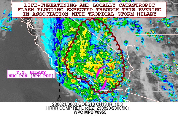
Areas affected...Southern CA...Southern NV

Concerning...Heavy rainfall...Flash flooding likely

Valid 210013Z - 210613Z

SUMMARY...Life-threatening and locally catastropic flash flooding
is expected this evening across large areas of southern California
as Tropical Storm Hilary advances north and brings and produces
very heavy rainfall totals. Meanwhile, heavy rains and flash
flooding concerns will be increasing over southern Nevada.

DISCUSSION...The late-day GOES-W 1-minute IR and visible satellite
imagery in conjunction with surface and radar observations shows
the center of weakening Tropical Storm Hilary lifting steadily
north across southern CA. As of 5PM PDT (00Z), the center of
Tropical Storm Hilary was centered 25 miles south-southwest of
Palm Springs, CA with the storm moving north at 23 mph.

Hilary continues to bring very heavy rainfall across southern CA
with very strong moisture transport and enhanced orographic
forcing/upslope flow working to maintain locally enhanced rainfall
rates that are occasionally reaching 1 to 1.5 inches/hour. Some of
this is being aided by the uptick seen over the last few hours of
boundary layer instability over southeast CA including the Mohave
and Colarado Deserts where MUCAPE values have risen to as high as
1000 to 2000 J/kg.

Strongly convergent southeast flow around the eastern flank of
Hilary coupled with the instability will result in some banded
convective structures heading through the evening hours impacting
portions of the Mohave Desert and also the upslope areas of the
southern Sierra Nevada. Meanwhile, some of the remaining central
convection and core of Hilary's rains will be concentrated over
the Transverse Range and southern portions of the San Joaquin
Valley, with this activity also crossing through the southern
Sierra Nevada over the next several hours.

Already there has been locally as much as 2 to 4 inches of rain
across some of the east and northeast facing slopes of the San
Gabriel and San Bernadino mountains of the Transverse Range in
just the last 6 hours, with storm totals amounts going back to
early this morning that are approaching 6 inches.

The 18Z HREF guidance along with recent runs of the HRRR and the
experimental WoFS guidance all generally show the 00Z to 06Z time
frame as generally being the window of the heaviest rains for
Hilary across southern CA with the heaviest amounts expected
generally over the San Gabriel and San Bernadino mountains, and to
a slightly lesser extent the southern Sierra Nevada where
additional rainfall amounts of 2 to 4 inches with isolated 5+ inch
amounts will be possible going through 06Z (11PM PDT). Expect
these rains to also be reaching over somewhat into the Nevada side
of the Sierra Nevada crest.

These rains will result in life-threatening and locally
catastrophic flash flooding impacts including debris flows,
landslides and mudslides going through the evening hours.

Orrison

ATTN...WFO...HNX...LKN...LOX...PSR...REV...SGX...VEF...

ATTN...RFC...CBRFC...CNRFC...NWC...

LAT...LON   38101720 37641652 36301559 34891511 33631515
            32591605 32551688 32791734 33531785 33721870
            34411929 35301938 36601867 37801817
Last Updated: 814 PM EDT Sun Aug 20 2023
|


