| WPC Met Watch |
|
|
Mesoscale Precipitation Discussion: #0960 (2023) |
|
(Issued at 500 AM EDT Tue Aug 22 2023
) |
|
| MPD Selection |
|
|
|
|
|

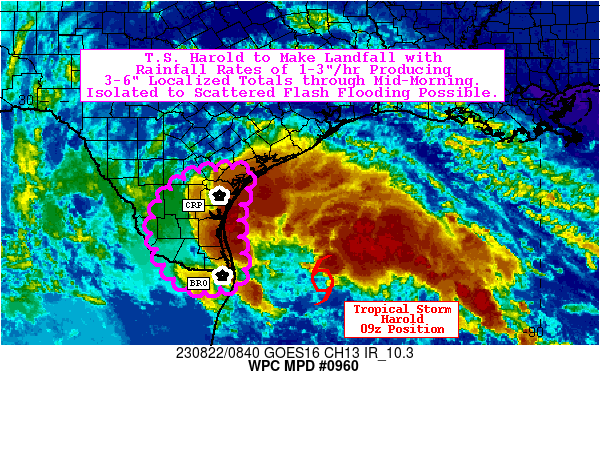
Mesoscale Precipitation Discussion 0960
NWS Weather Prediction Center College Park MD
500 AM EDT Tue Aug 22 2023

Areas affected...South Texas

Concerning...Heavy rainfall...Flash flooding possible

Valid 220900Z - 221500Z

Summary...Tropical Storm Harold to make landfall by midday. Rain
bands will produce 1-3"/hr rainfall rates with localized totals of
3-6" expected through mid-morning. Isolated to scattered flash
flooding is possible.

Discussion...Tropical Storm Harold is approaching landfall along
the South Texas coast this morning, moving west-northwest at 15
kts (as of the 09z advisory). Rain bands are already making their
way onshore, and MRMS is currently estimating peak localized
rainfall rates of 1-2"/hr. These rates are generally expected to
persist well through landfall, though rates may also occasionally
reach the 2-3"/hr range (with frictional convergence locally
strengthening updrafts). The highest localized totals (expected to
be 3-6" through 15z) will mainly occur along and near the
coastline (from Brownsville north to Corpus Christi) in
association with the core of tropical moisture (PWATs of 2.6"+,
above the max moving average per BRO/CRP sounding climatology) and
most persistent low-level easterly flow and associated strong
moisture transport. The good news is that the bulk of this
rainfall will be beneficial for the drought-stricken region, but
too much rainfall too fast could lead to isolated to scattered
instances of flash flooding (particularly within poor drainage
metropolitan areas). The 00z HREF indicates 40-km neighborhood
probabilities for 5" exceedance of 15-25% (through 15z), which
corresponds to a 10-20% probability of exceedance for associated
Flash Flood Guidance.

Churchill

ATTN...WFO...BRO...CRP...

ATTN...RFC...WGRFC...NWC...

LAT...LON   28329683 27429706 26489699 25799700 25599793
            25919861 26919908 27739880 28329800
Last Updated: 500 AM EDT Tue Aug 22 2023
|


