| WPC Met Watch |
|
|
Mesoscale Precipitation Discussion: #0969 (2021) |
|
(Issued at 731 AM EDT Wed Sep 15 2021
) |
|
| MPD Selection |
|
|
|
|
|

Mesoscale Precipitation Discussion 0969
NWS Weather Prediction Center College Park MD
731 AM EDT Wed Sep 15 2021

Areas affected...Gulf Coast from Vermilion Bay, LA to
Apalachicola, FL

Concerning...Heavy rainfall...Flash flooding likely

Valid 151130Z - 151700Z

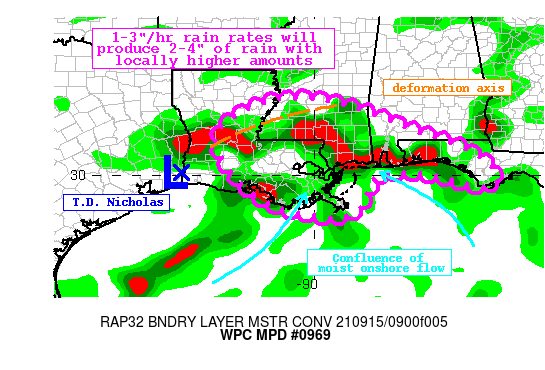
Summary...Tropical Depression Nicholas will drift eastward today,
persisting heavy rain across the Gulf Coast. Rainfall rates at
times may approach 3"/hr in bands rotating onshore, and widespread
2-4" of rain is likely. Locally much higher amounts, possibly
exceeding 6", are also possible. Flash flooding is likely.

Discussion...Tropical Depression Nicholas was located 15 miles NNE
of Port Arthur, TX at 0900Z this morning, drifting eastward at 3
mph. The circulation associated with Nicholas is clearly evident
on CIRA LPW observations, with a plume of PWs of 2.25 - 2.4 inches
surging northward into the Gulf Coast noted on the Blended TPW
product. These PWs are well above the 90th climatological
percentile, and approaching daily records for the region. A punch
of drier air is also noted rotating around Nicholas from the SW
and advecting towards the coast, and while this will somewhat
limit rainfall closer to the center of the T.D. keeping they
heaviest rain well to the north and east, any weak low-level
convergence will still be able to produce narrow bands of tropical
rainfall through the aftn.

The regional radar mosaic depicts an expansive shield of moderate
rainfall stretching from near Alexandria, LA to Tuscaloosa, AL,
with embedded convective lines to the south and into the Gulf of
Mexico. This will likely remain the overall pattern today. As
Nicholas continues to drift eastward, an expanding warm sector
south of the effective warm/coastal front will drive continued WAA
and moisture/instability onshore. At the same time, a deformation
axis noted on the local radars extending northeast from the center
into MS will act as a secondary maxima of ascent, and two regions
of heavy rainfall with flash flooding are expected.

Within this deformation axis, forcing will persist and intensify
through the aftn. The eastward drift of Nicholas will at least
subtly pinch the gradient to intensify low-level flow into this
axis. As this occurs, modest upper level divergence will result in
increase of low-level frontogenesis collocated with this axis to
produce a laterally translating band of moderate to at times heavy
rainfall. This should produce a narrow corridor of 1-3" of
rainfall with isolated higher amounts from near Alexandria, LA to
along the I-20 corridor of MS. The CONEST, ARW2, HREFPMM, and
recent HREF probabilities all indicate this localized max. While
rain rates within this axis may be more moderate, 0.5-1"/hr,
continuous advection of moisture to produce persistent heavy rain
may still produce flash flooding.

Further to the south, intense WAA within a region of extreme PWs
and MLCape climbing to 1500 J/kg should produce bands of tropical
rainfall rates exceeding 2"/hr. Confluent low-level flow over the
Gulf of Mexico within these intense thermodynamics will lead to
several bands of thunderstorms, within which the HREF suggests
will have 2-3"/hr rain rates. While individual cell motions are
likely to be quick on 0-6km mean wind of 20-25 kts, strongly
opposed propagation vectors indicate backbuilding into the greater
instability and training northward as the bands themselves drift
slowly eastward. These bands could produce locally in excess of 6"
through this aftn, as the WAA isentropically ascends the effective
warm front, with lift enhanced by frictional convergence as well.
The greatest risk area for these bands is far SE LA, including New
Orleans, extending eastward to Mobile Bay and the western FL
Panhandle. Should any of these bands train perfectly across an
urban area, significant flash flooding would be possible.


Weiss

ATTN...WFO...JAN...LCH...LIX...MOB...SHV...TAE...

ATTN...RFC...LMRFC...SERFC...NWC...

LAT...LON   32199087 32199001 31968899 31568788 31278715
            30848587 30448518 30088478 29708484 29698525
            29718542 29908614 30078699 30078788 30078813
            29878831 29448852 29028871 28808932 28868994
            28999069 29279141 29779209 30219247 30779274
            31309270 31719217 32029157
Last Updated: 731 AM EDT Wed Sep 15 2021
|


