| WPC Met Watch |
|
|
Mesoscale Precipitation Discussion: #1006 (2018) |
|
(Issued at 945 PM EDT Fri Nov 02 2018
) |
|
| MPD Selection |
|
|
|
|
|

Mesoscale Precipitation Discussion 1006
NWS Weather Prediction Center College Park MD
945 PM EDT Fri Nov 02 2018

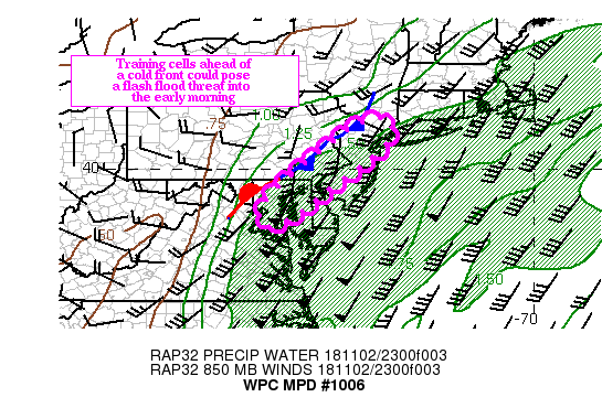
Areas affected...Northeast MD...northern DE...eastern PA...NJ into
the NYC metro area

Concerning...Heavy rainfall...Flash flooding possible

Valid 030145Z - 030545Z

Summary...Low topped convection training ahead of a cold front
approaching the mid Atlantic states could pose a flash flood
threat into the early morning hours.

Discussion...A batch of moderate to heavy rain, a product of
isentropic lift over a quasi stationary boundary extending from
eastern PA into central MD. In this area, rainfall rates  have
generally averaged less than 0.50 inches, based on radar estimates
and surface observations.

Behind this area, low topped, forced convection has formed in a
line ahead of the front from central MD into central VA. The
convection is forming in the presence of 100-250 J/KG of MUCAPE
(as seen on the 00z soundings from IAD and OKX, and as the line
moves eastward, the individual cells in the line track north
northeast. Ahead of front, a 40 to 50 knot low level southwest jet
transports 1.25/1.50 inch precipitable water air (per recent GPS
observations, which is between two and three standard deviations
above the mean) across the Mid Atlantic.

As the convection moves across VA/MD into eastern PA, it taps the
deep moisture in place. Hourly rainfall rates between 1.00/1.50
inches are possible where the convection trains along the line (as
depicted by the most recent HRRR runs), especially over portions
of northeast MD into southeast PA. Three hour flash flood guidance
values in these areas are generally above 2.50 inches, so training
would be necessary to initiate flash flooding. The main threat
could end up being urban flooding, especially through southeast PA
into western NJ.

The window for flash flooding is tied to the relatively
progressive movement of the convection, and the marginal
instability profiles. At this point, flash flooding is only
considered possible.

Hayes

ATTN...WFO...CTP...LWX...OKX...PHI...

ATTN...RFC...MARFC...NERFC...

LAT...LON   41287379 41047364 40647383 40197432 39507527
            38827612 38497688 38487693 38847710 39507665
            40997482 41277413
Last Updated: 946 PM EDT Fri Nov 02 2018
|


