| WPC Met Watch |
|
|
Mesoscale Precipitation Discussion: #1020 (2023) |
|
(Issued at 505 PM EDT Fri Sep 01 2023
) |
|
| MPD Selection |
|
|
|
|
|

Mesoscale Precipitation Discussion 1020
NWS Weather Prediction Center College Park MD
505 PM EDT Fri Sep 01 2023

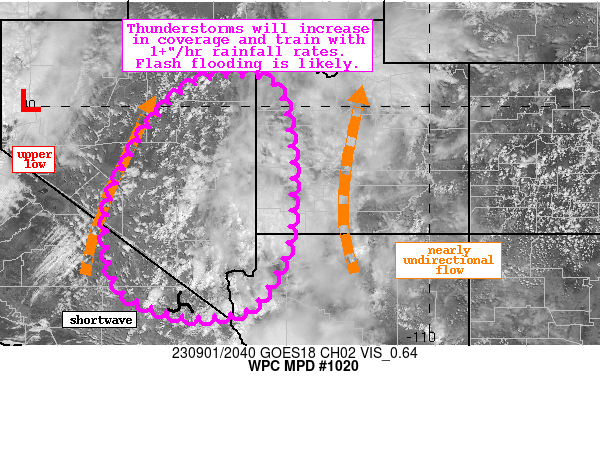
Areas affected...Portions of the Great Basin

Concerning...Heavy rainfall...Flash flooding likely

Valid 012104Z - 020300Z

Summary...Showers and thunderstorms will increase in coverage and
intensify through this evening. These storms will lift northward
and train, with 1+"/hr rain rates resulting in axes of 2-3" of
rainfall. Flash flooding is likely.

Discussion...The regional radar mosaic this afternoon indicates
widespread showers and thunderstorms developing across the low
deserts of CA and into southern AZ, with additional thunderstorms
blossoming near Las Vegas, NV. These storms are being pulled
northward within nearly unidirectional flow between an anomalous
upper low digging across CA evident on WV imagery, and a
retreating but expansive ridge of high pressure to the east.
Southerly flow between these two features is being pinched,
driving anomalous moisture transport northward noted by PWs
measured by GPS reaching 1.8 inches, as high as +3 standard
deviations, extending into eastern NV. This is combining with
SBCAPE of 1000-2000 J/kg to provide an extremely favorable
environment for convection with heavy rain. Additionally, weak
shortwaves embedded within the flow are lifting northward to
provide additional ascent, which when combined with effective bulk
shear of 25-35 kts will result in clusters of organized
thunderstorms continuing through the evening.

Rainfall rates as estimated by local radars have been 1-1.5"/hr in
many cells, and these rates are likely to continue as reflected by
HREF neighborhood probabilities for 1+"/hr peaking above 50% by
02Z, coincident with the UA WRF hourly precipitation showing
widespread areas of 0.75" or higher. This is also reflected by the
HRRR sub-hourly fields indicating 15-min rainfall that may reach
0.5". The continued northerly flow is progged to drive PW
anomalies above +3 sigma as far as 40N this evening according to
the SREF, which further supports the high-res simulated
reflectivity expanding convection much farther north through the
evening. With mean 0-6km winds of around 20 kts aligned to the
Corfidi vectors, it is likely these showers and thunderstorms will
train in many areas, resulting in the HREF exceedance
probabilities for 3"/6hrs as high as 40%.

14-day rainfall across the Great Basin has been generally above
300% of normal, and USGS streamflow anomalies are well above the
90th percentile in many areas. This has led to compromised FFG
which could quickly be overwhelmed by these intense rates despite
the generally progressive cells. Flash flood warnings are already
in effect in some areas, and additional instances of flash
flooding, with even more expansive coverage, is likely as
convection lifts northward during the next several hours.


Weiss

ATTN...WFO...LKN...SLC...VEF...

ATTN...RFC...CBRFC...CNRFC...NWC...

LAT...LON   40641504 40621388 40141345 38871323 38221322
            36921329 36151354 35321414 35141466 35091527
            35111581 35321647 35841729 37481749 39061682
            40271583
Last Updated: 505 PM EDT Fri Sep 01 2023
|


