| WPC Met Watch |
|
|
Mesoscale Precipitation Discussion: #1030 (2022) |
|
(Issued at 912 PM EDT Thu Sep 22 2022
) |
|
| MPD Selection |
|
|
|
|
|

Mesoscale Precipitation Discussion 1030
NWS Weather Prediction Center College Park MD
912 PM EDT Thu Sep 22 2022

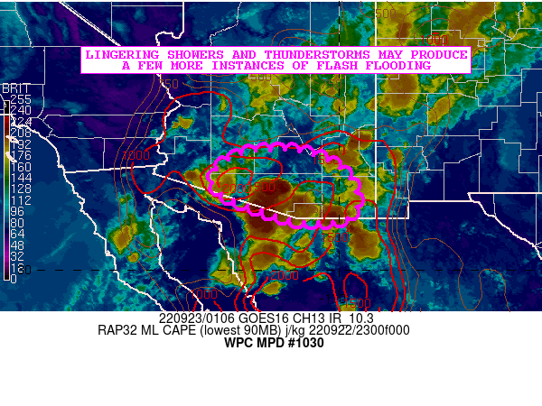
Areas affected...Far Southern AZ

Concerning...Heavy rainfall...Flash flooding possible

Valid 230110Z - 230410Z

SUMMARY...Scattered showers and thunderstorms should still persist
for a few more hours across portions of far southern AZ. A few
more instances of flash flooding will be possible.

DISCUSSION...The latest GOES IR satellite imagery still shows some
cold-topped convection lingering across portions of far southern
AZ as some smaller-scale boundary collisions continue from the
ongoing convective outflows. The airmass is still rather unstable
though with the latest RAP analysis showing MLCAPE values still
upwards of 1500+ j/kg.

This instability coupled with the continued presence of a
moisture-rich environment with PWs locally over 1.75 inches should
continue to favor some convection with very heavy rainfall rates
for a few more hours. The convective overturning process and an
increase in boundary layer CINH via nocturnal cooling should allow
for the convection to weaken and gradually dissipate by mid to
late evening.

A few of the remaining stronger cells may still be capable of
producing rainfall rates of up to 1 to 1.5 inches/hour, with a
couple of spotty amounts perhaps of around 2 inches where any very
small-scale cell-mergers occur. Thus, a few more instances of
flash flooding cannot be ruled out given the lingering convection
over the next few hours.

Orrison

ATTN...WFO...PSR...TWC...

ATTN...RFC...CBRFC...NWC...

LAT...LON   33091215 33031090 32550988 31870955 31340985
            31281109 31651224 31911293 32321330 32791293
Last Updated: 912 PM EDT Thu Sep 22 2022
|


