| WPC Met Watch |
|
|
Mesoscale Precipitation Discussion: #1054 (2022) |
|
(Issued at 903 AM EDT Fri Sep 30 2022
) |
|
| MPD Selection |
|
|
|
|
|

Mesoscale Precipitation Discussion 1054
NWS Weather Prediction Center College Park MD
903 AM EDT Fri Sep 30 2022

Areas affected...Central/Eastern SC

Concerning...Heavy rainfall...Flash flooding likely

Valid 301302Z - 301902Z

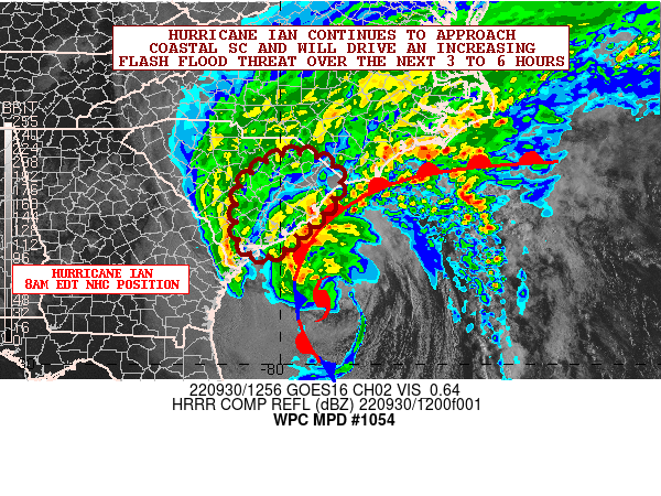
SUMMARY...Hurricane Ian continues to approach the South Carolina
coast and will be bringing increasingly heavy rainfall over the
next several hours. The threat for flash flooding will be on the
increase this morning and into the afternoon hours.

DISCUSSION...The center of Hurricane Ian as of 8AM EDT was
centered 105 miles south-southeast of Charleston, SC and was
moving to the north at 9 mph. GOES-16 satellite imagery continues
to depict Ian's approach on coastal SC as a hybrid tropical
cyclone, but with increasingly well-defined
baroclinic/extratropical features given an expanding deformation
zone and associated mid-level comma-head feature over the SC
Lowcountry, and surface observations showing a well-defined front
wrapped around the northern and western flanks of the storm's
circulation. Nevertheless, Ian still has a fair degree of central
convection just northwest of its center, and suggestive of warm
core processes.

Radar imagery shows moderate to heavy rain already overspreading
the SC Lowcountry around the northwest flank of Ian's circulation
which is being aided by the strong Atlantic moisture
transport/convergence and robust frontogenetical forcing given the
increasing interaction of Ian with the aforementioned frontal
zone. There is some dry air intrusion currently noted from coastal
areas of southeast NC down through eastern SC which has eroded the
rains across this region over the last couple of hours, but radar
imagery along with GLM-derived lightning data shows robust
convection associated with Ian's inner core offshore which will be
approaching this morning and will be moving inland this afternoon
as Ian prepares to make a second and final U.S. landfall.

This inner core convection will yield some very heavy rainfall
rates that will likely approach and exceed 2 inches/hour. Recent
HRRR runs show some training of these very heavy rainfall rates
along and just west of Ian's track as it approaches the upper SC
coast (Grand Strand region) toward midday and through the early to
mid-afternoon hours, and this will support enhanced rainfall
amounts by mid-afternoon that may reach 3 to 6 inches. This is
also generally supported by the overnight HREF model consensus.

Despite dry antecedent conditions, the moderate to heavy rains
arriving ahead of Ian will act to moisten the soil conditions such
that when Ian's inner core convection arrives later this morning
and this afternoon, there should be increased sensitivity to these
heavy rainfall rates which should enhance the flash flooding
threat.

The urban corridors along the coast from Charleston northeastward,
and especially the Grand Strand from Georgetown to Myrtle Beach,
will be prone to significant flooding/flash flooding concerns and
especially with considerations of tidal flooding/storm surge
inundation ahead of Ian.

Orrison

ATTN...WFO...CAE...CHS...ILM...

ATTN...RFC...SERFC...NWC...

LAT...LON   34418005 34357912 33947873 33537888 33147916
            32787964 32417996 32338048 32618083 33698084
Last Updated: 903 AM EDT Fri Sep 30 2022
|


