| WPC Met Watch |
|
|
Mesoscale Precipitation Discussion: #1059 (2022) |
|
(Issued at 402 PM EDT Fri Sep 30 2022
) |
|
| MPD Selection |
|
|
|
|
|

Mesoscale Precipitation Discussion 1059
NWS Weather Prediction Center College Park MD
402 PM EDT Fri Sep 30 2022

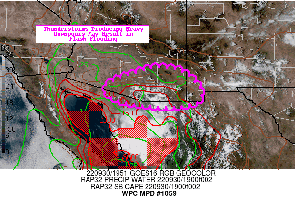
Areas affected...Southern Arizona...New Mexico Bootheel

Concerning...Heavy rainfall...Flash flooding possible

Valid 302000Z - 010130Z

SUMMARY...Slow moving thunderstorms may result in flash flooding
in dry washes, along rugged terrain, and in areas with overly
sensitive soils.

DISCUSSION...The 500mb disturbance in Sonora that led to
yesterday's scattered strong thunderstorms has not moved much.
Compared to yesterday, however, there is less mid-high level cloud
cover over southern Arizona and far southwest New Mexico. This is
resulting in SBCAPE values that will reach as high as 1,000 J/kg,
which also coincides in an environment where PWs are >1". The
higher terrain of southeast Arizona is favored to generate strong
storms again this afternoon. These storms are forming in a similar
area to yesterday that saw thunderstorms, and 0-40cm soil moisture
percentiles courtesy of NASA SPoRT-LIS remain around ~90%. 12Z
HREF probabilities for 1-hr QPF > 1-hr FFGs were as high as 20-30%
between 20-00Z. Areas most susceptible to flash flooding are where
the most saturated soils are located, as well as in normally dry
washes and along rugged terrain.

Mullinax

ATTN...WFO...EPZ...TWC...

ATTN...RFC...CBRFC...WGRFC...NWC...

LAT...LON   32971038 32770927 31990848 31300854 31081005
            31121071 31391229 31861297 32291265 32591181
            32921079
Last Updated: 402 PM EDT Fri Sep 30 2022
|


