| WPC Met Watch |
|
|
Mesoscale Precipitation Discussion: #1062 (2022) |
|
(Issued at 932 PM EDT Fri Sep 30 2022
) |
|
| MPD Selection |
|
|
|
|
|

Mesoscale Precipitation Discussion 1062
NWS Weather Prediction Center College Park MD
932 PM EDT Fri Sep 30 2022

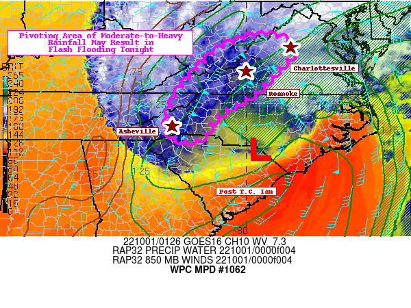
Areas affected...South-Central Appalachians

Concerning...Heavy rainfall...Flash flooding possible

Valid 010130Z - 010700Z

SUMMARY...Deformation axis setting up over the south-central
Appalachians with favorable upsloping easterly low-mid level flow
will result in a prolonged period of heavy rainfall rates. This
may result in flash flooding, especially along creek beds, in poor
drainage areas, and in urbanized communities.

DISCUSSION...Post Tropical Cyclone Ian is working its way into the
North Carolina Piedmont this evening as a sharp 250mb trough over
the Mid-South also generates 250-500mb PVA over the southern
Mid-Atlantic. At low levels, an influx of 850-700mb moisture flux
is being directed from the VA/NC Tidewater on west into the
Southern Appalachians. This combination of a WCB and corresponding
deformation axis, along with easterly upslope flow into the
eastern slopes of the Appalachians, will result in a prolonged
period of moderate-to-heavy rainfall. Rainfall rates are likely to
increase over southwest VA and into western NC, in particular, as
the stronger easterlies closer to Ian's center approach the region
this evening. PWs >1.5" will be directed into the highlighted
region, but the one inhibiting factor will be the lack of
instability over the region.

Most hourly rainfall rates will struggle to get above 0.75"/hr,
but cumulatively over the span of 3-6 hours, some locations could
challenge 3-6 hr FFGs. The areas with the best odds of seeing
hourly rates >0.75"/hr will be on the northwest side of Ian's
remnant low level circulation. The 18Z HREF shows southwest VA
with the highest probabilities of 6-hr QPF > 10 year ARIs, which
are as high as 50% between 06-12Z. As soils saturate overnight,
any of the heavier rainfall rates on Ian's northwest flank will
have the better chances for causing flash flooding, especially
where winds are positioned orthogonally to nearby mountainous
terrain in southwest VA and western NC. Locations most susceptible
to flash flooding are near creek beds, along rugged terrain, in
poor drainage areas, and in urbanized communities that contain a
greater concentration of hydrophobic surfaces.

Mullinax

ATTN...WFO...GSP...LWX...MRX...RAH...RLX...RNK...

ATTN...RFC...LMRFC...MARFC...OHRFC...SERFC...NWC...

LAT...LON   38507966 38437875 38067837 37317904 36737957
            36348017 36008080 35718112 35428129 35218136
            35098150 35028189 35088241 35438267 36348243
            37208179 38078085
Last Updated: 932 PM EDT Fri Sep 30 2022
|


