| WPC Met Watch |
|
|
Mesoscale Precipitation Discussion: #1073 (2024) |
|
(Issued at 447 AM EDT Fri Sep 27 2024
) |
|
| MPD Selection |
|
|
|
|
|

Mesoscale Precipitation Discussion 1073...Corrected
NWS Weather Prediction Center College Park MD
447 AM EDT Fri Sep 27 2024

Corrected for typo in summary section

Areas affected...northeastern GA into western SC/NC and
southwestern VA

Concerning...Heavy rainfall...Flash flooding likely

Valid 270830Z - 271430Z

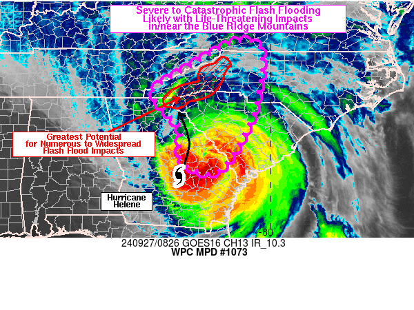
SUMMARY...Severe to catastrophic flash flooding will be likely for
portions of western SC/NC this morning. Additional rainfall totals
of 4 to 7 inches, at least locally through 14Z, will pose a threat
to life with potential for landslides due to saturated soils and
swollen rivers/creeks.

DISCUSSION...Hurricane Helene was located over eastern GA at 08Z,
just north of Eastman, tracking rapidly toward the NNE between
25-30 kt over the past 6 hours. Water vapor imagery showed Helene
interacting with a closed upper level low over northeastern AR,
which is expected to cause the hurricane to turn toward the
northwest later this morning. Recent trends in infrared satellite
imagery showed some cloud top warming with Helene, indicative of
weakening, but Helene remained a large and powerful tropical
system with a symmetric appearance in colder cloud tops.

925-850 mb winds were strongest to the east of Helene, with VAD
wind data at KCLX showing 80-90 kt, with area VAD winds showing
50-70 kt from the western NC/SC border into northeastern GA.
Gradual weakening of these winds is expected over the next 3-6
hours and the quick northward motion will at least limit the
duration of extreme moist ascent into the terrain but a
significant duration of high rainfall rates is still anticipated
into portions of the Blue Ridge. As Helene continues its northward
track, expect rainfall rates of 1-2 in/hr to expand northward with
potential for some terrain locations to see 2-4 hours of rainfall
rates near/above 1 in/hr.

Estimated rainfall totals (via multi-sensor MRMS output) showed 6
to 12+ inches of rain have fallen over the past 48 hours from
northeastern GA into western SC/NC along the southeast facing
slopes of the Blue Ridge Mountains. Areas of flash flooding are
already ongoing and widespread across the region and an additional
4 to 7 inches (locally) through 14Z is expected to produce severe
to catastrophic levels of flash flooding with potential for
landslides and threats to life and property. Experimental WoFS
data from 07Z showed the probability of exceeding 5 inches through
13Z to be 70+ percent in eastern Yancey County and 40+ percent in
southern Haywood County (both in western NC) where upslope
enhancement is expected to be maximized due to terrain influences.
This is a high confidence forecast and there is strong model
support for the location of heaviest rainfall over the next 6
hours.

Otto

ATTN...WFO...CAE...CHS...FFC...GSP...MRX...RAH...RNK...

ATTN...RFC...LMRFC...OHRFC...SERFC...NWC...

LAT...LON   36918091 36708038 35898033 34948050 34238069
            32818146 32448197 32538252 32798296 33168308
            33918302 34638360 35238396 35928289 36668161
Download in GIS format: Shapefile
| KML
Last Updated: 447 AM EDT Fri Sep 27 2024
|


