| WPC Met Watch |
|
|
Mesoscale Precipitation Discussion: #1096 (2023) |
|
(Issued at 222 PM EDT Sat Sep 23 2023
) |
|
| MPD Selection |
|
|
|
|
|

Mesoscale Precipitation Discussion 1096
NWS Weather Prediction Center College Park MD
222 PM EDT Sat Sep 23 2023

Areas affected...northern North Carolina, central/eastern
Virginia, southern Maryland, southern Delaware, and the District
of Columbia

Concerning...Heavy rainfall...Flash flooding likely

Valid 231822Z - 240030Z

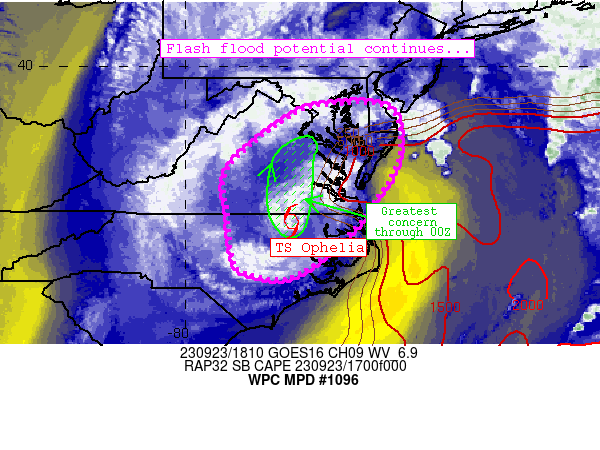
Summary...Heavy rainfall associated with Tropical Storm Ophelia
continues to promote considerable flash flood potential across the
discussion area this afternoon.

Discussion...The center of Ophelia continues to move northward
across eastern North Carolina and was located near the NC/VA
border southwest of Norfolk.  Bands of heavy precipitation have
continued to produce areas of 1+ inch/hr rain rates over multiple
hours both near the center (near Roanoke Rapids) and also
west-through-southwest of the center near Raleigh metro.  The bulk
of flash flood potential has been located with this activity.
Meanwhile, scattered convection has progressed fairly quickly
across the DelMarVa that has managed to produce spots of 0.5-0.75
inch/hr rain rates while wetting soils downstream of Ophelia.

The overall flash flood scenario with Ophelia continues and
remains separated into these two separate regimes: 1) with
concentrated/banded convection near the center and just west of
the storm and 2) with banded convection forming in a slightly more
buoyant airmass northeastward toward the DelMarVa.  So far, the
more concentrated flash flood threat has evolved over North
Carolina (with at least one report of closed roadways near
Greenville).  Prolonged heavy rainfall in these areas have
resulted in 2-7 inches storm total precipitation and wet soils
supporting efficient runoff.  Flash flooding remains likely in
this scenario, and the better risk should continue to spread
northward toward the I-95 corridor in eastern Virginia (including
Richmond Metro) through 00Z.

Farther to the northeast (from far southeastern Virginia
northeastward to the DelMarVa), lighter rain rates have generally
materialized despite notable banding of convection.  Rain has
generally remained fairly progressive, although the presence of
strong low-level convergence and buoyancy in these areas may still
promote isolated flash flood potential especially if convective
bands stall and manage to produce higher rain rates through 00Z.

Cook

ATTN...WFO...AKQ...LWX...MHX...PHI...RAH...RNK...

ATTN...RFC...MARFC...SERFC...NWC...

LAT...LON   39147575 38877510 37797505 36717569 35827644
            35067760 35217870 35607890 36487900 37637899
            38897746 39097665
Last Updated: 222 PM EDT Sat Sep 23 2023
|


