| WPC Met Watch |
|
|
Mesoscale Precipitation Discussion: #1100 (2024) |
|
(Issued at 730 PM EDT Wed Oct 09 2024
) |
|
| MPD Selection |
|
|
|
|
|

Mesoscale Precipitation Discussion 1100
NWS Weather Prediction Center College Park MD
730 PM EDT Wed Oct 09 2024

Areas affected...north-central FL Peninsula

Concerning...Heavy rainfall...Flash flooding likely

Valid 092328Z - 100445Z

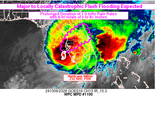
SUMMARY...An axis of extreme rainfall, stretching from the Tampa
metropolitan region northeastward into the north-central FL
Peninsula, is expected to result in major to locally catastrophic
flash flooding with considerable threats to life and property.
6-hr rainfall totals of at least 5-8 inches with hourly rainfall
in the 2-3 in/hr range are expected.

DISCUSSION...The 23Z update from NHC placed the center of
Hurricane Milton 35 miles WSW of Sarasota, FL. Local radar imagery
at 23Z from KTBW showed the heaviest rain located within what is
effectively the northern eyewall which has pushed ashore and arced
from Manatee into southern Hillsborough and much of Pinellas
counties with MRMS and gauge data showing 1-2 in/hr rainfall
rates. Portions of St. Petersburg to Bradenton have already picked
up 5-8 inches of rain since midnight and flash flooding is
ongoing. Farther east, an outer rain band had largely moved
offshore of the eastern Peninsula but was arcing northwestward
ashore just north of Cape Canaveral with 4-8 inches already
reported across Brevard County.

An axis of strong low level convergence tied to the northern
eyewall, extending northeast from the center of Milton to Volusia
County (just north of the forecast track of Milton) will support a
prolonged period of high rainfall rates, 1-2 in/hr but locally in
the 2 to 3+ in/hr range, with the axis training from WSW to ENE
and slowly lifting north with time. Some locations could
experience rainfall rates in excess of 1 in/hr for 2-4 hours,
causing rapid rises of water above the surface as water will not
have sufficient time to drain, especially across the mostly
impervious surfaces of the St. Petersburg into the Tampa metro and
possibly nearing Orlando later tonight. Additional rainfall of at
least 5-8 inches is expected from St. Petersburg, northeastward
into the central Peninsula where the WoFS has consistently painted
high probabilities of exceeding 5 inches of rainfall. The 22Z WoFS
cycle indicated 50 to 90 percent probabilities of 5+ inches and
90th percentile (reasonable worse case scenario) values of 7-10
inches. Major to locally catastrophic flash flooding is expected
as a result of these high rainfall rates.

Otto

ATTN...WFO...JAX...MLB...TBW...

ATTN...RFC...SERFC...NWC...

LAT...LON   29888111 29688103 28598054 28528063 28238143
            27798205 27438295 27898313 28898262 29318212
            29678163
Download in GIS format: Shapefile
| KML
Last Updated: 730 PM EDT Wed Oct 09 2024
|


