| WPC Met Watch |
|
|
Mesoscale Precipitation Discussion: #1103 (2021) |
|
(Issued at 754 AM EDT Mon Oct 25 2021
) |
|
| MPD Selection |
|
|
|
|
|

Mesoscale Precipitation Discussion 1103
NWS Weather Prediction Center College Park MD
754 AM EDT Mon Oct 25 2021

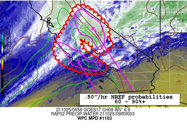
Areas affected...Portions of Central to Southern California

Concerning...Heavy rainfall

Valid 251200Z - 251800Z

Summary...The ongoing strong atmospheric river event will begin to
weaken later this morning, but continue to produce heavy rains
through this morning as the heaviest rains shift southward into
portions of Central to Southern California.

Discussion...The intense atmospheric river event that has affected
large portions of Northern and Central California over the past 48
hours is shifting southward into Central to Southern California
this morning.  While there are indications that there will be
weakening of this atmospheric river event later this morning,
heavy rains are likely to continue in the axis of anomalous pw
values...2 to 3+ standard deviations above the mean...that are
expected to persist this morning in the strong west southwesterly
low level onshore flow axis along and ahead of the frontal
boundary sinking southward into Southern California.  HREF
neighborhood probabilities for .50"+ hourly amounts are forecast
to remain high over the next 6 hours through the Southern Sierra
and into the Central to Southern California Coastal Range from Big
Sur southward to near and north of Ventura with values 60-90%+.
This will pose a threat of flash flooding and debris flow problems
across recent burn scar areas.  This is especially so across the
Willow and French burn scars where probabilities of debris flow
are high as per the USGS Post Fire   Debris Flow Hazards.

The simulated radars from the latest hi res guidance is depicting
the ongoing event well, leading to above average confidence in
heavy rain threat this morning.  There is good agreement with hi
res model qpfs over the next 6 hours with consensus for widespread
1-2"+ amounts across the Coastal Ranges and 1.5 to 3"+ amounts
over the Southern Sierra.

Oravec

ATTN...WFO...HNX...LOX...MTR...REV...STO...VEF...

ATTN...RFC...CNRFC...NWC...

LAT...LON   38951969 38271876 37411800 36591799 36061768
            35971785 35501858 36161922 36511969 36492005
            35641978 34961877 34231804 34071960 34812139
            35762197 36932144 38162072 38862049 38922040
Last Updated: 754 AM EDT Mon Oct 25 2021
|


