| WPC Met Watch |
|
|
Mesoscale Precipitation Discussion: #1110 (2023) |
|
(Issued at 1135 PM EDT Thu Sep 28 2023
) |
|
| MPD Selection |
|
|
|
|
|

Mesoscale Precipitation Discussion 1110
NWS Weather Prediction Center College Park MD
1135 PM EDT Thu Sep 28 2023

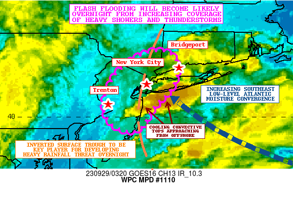
Areas affected...Central/Northern NJ...Southeast NY and Long
Island...Southwest CT

Concerning...Heavy rainfall...Flash flooding likely

Valid 290335Z - 290935Z

SUMMARY...Showers and thunderstorms are expected to be on the
increase overnight across the greater New York City metropolitan
area along with adjacent suburbia. Flash flooding is likely to
occur given wet antecedent conditions and urban sensitivities to
heavy rainfall rates.

DISCUSSION...GOES-E IR satellite imagery in conjunction with area
Dual-Pol radar shows an area of heavier shower activity beginning
to set up and focus just offshore of northern NJ and south of the
western tip of Long Island. The convection is gradually advancing
off to the north-northwest and is becoming increasingly focused
along a sharpening inverted surface trough situated near coastal
areas of NJ and stretching north up into far southeast NY.

Coinciding with this is a surge of moist southeast low-level
Atlantic flow aiming into the eastern flank of this surface
trough, and the latest experimental CIRA-LVT data shows this surge
of stronger moisture transport showing up in the SFC/850 and
850/700 mb layers. Some of the developing and expanding areas of
convection are noted near the nose of this and the intersection
with the inverted trough.

The instability parameters across the region are very modest with
MUCAPE values of 250 to 500 J/kg pooled across western Long Island
and down across central/southern NJ and the adjacent offshore
waters. However, over the next several hours, there should be some
increase in the instability along the inverted surface trough, and
there should only be a further increase in deeper layer
ascent/forcing as height falls associated with an upper-level
trough over the OH Valley begin to overspread the region. This
should only further encourage a stronger low-level response with a
corresponding focus for slow-moving and heavy shower activity
including a few thunderstorms.

In fact, a look at the 00Z HREF guidance suggests rainfall rates
will be capable of reaching 1 to 2 inches/hour with convective
cells tending to be locally focused/anchored along the
aforementioned north/south inverted trough. An increase in the
coverage of convection across coastal areas of central and
northern NJ, far southeast NY and western Long Island, and
possibly areas of southwest CT can be expected after 06Z (2AM EDT)
and especially by 09Z (5AM EDT).

Expect locally as much as 2 to 4 inches of rain, with isolated
heavier amounts, to be possible by dawn. This coupled with wet
antecedent conditions will likely result in areas of flash
flooding. There will be an elevated concern for runoff problems
and urban flooding involving the New York City metropolitan area
and some of the adjacent suburbs as these heavier rains evolve
overnight and especially toward dawn.

Orrison

ATTN...WFO...ALY...OKX...PHI...

ATTN...RFC...MARFC...NERFC...NWC...

LAT...LON   41567347 41297318 40757326 40227373 39767402
            39667434 39857474 40167489 40557485 41007463
            41457405
Last Updated: 1135 PM EDT Thu Sep 28 2023
|


