| WPC Met Watch |
|
|
Mesoscale Precipitation Discussion: #1115 (2021) |
|
(Issued at 1129 AM EDT Fri Oct 29 2021
) |
|
| MPD Selection |
|
|
|
|
|

Mesoscale Precipitation Discussion 1115
NWS Weather Prediction Center College Park MD
1129 AM EDT Fri Oct 29 2021

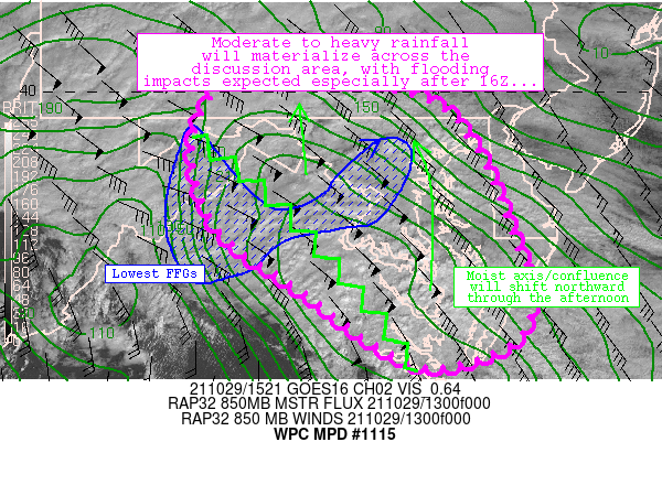
Areas affected...northern Virginia, much of Maryland, District of
Columbia, and southern Pennsylvania

Concerning...Heavy rainfall...Flash flooding possible

Valid 291525Z - 292100Z

Summary...The overall flash-flood risk should increase through the
afternoon as deepening convection traverses sensitive and/or
hydrophobic land surfaces.

Discussion...Recent radar/satellite mosaic imagery indicates a
broad warm conveyor extending from southeastern Virginia
north-northwestward across the central Appalachians into
southwestern Pennsylvania.  Isentropic and orographic lift was
resulting in broad areas of light to moderate rainfall, with the
highest rates located near Charlottesville (0.2-0.5 in/hr) and
southwest of Richmond (nearing 1 in/hr).  An axis of weak
instability was collocated within the southern extent of the warm
conveyor, which was likely helping to enhance rain rates
near/southwest of Richmond.  Meanwhile, light rainfall elsewhere
across the discussion area was resulting in wet soils.

Observations/model guidance all points to a gradual
intensification of convection in central Virginia in concert with
increasing instability in upstream areas near the Chesapeake Bay
and adjacent Atlantic waters.  Rates should locally exceed 1 in/hr
at times - especially as a rather focused band of convection
organizes and grows upscale while shifting northward toward
northern VA and the DC Metropolitan areas.  Meanwhile, FFGs were
lowest in/near DC/Baltimore southwestward toward the Blue Ridge
Mountains near Charlottesville (less than 1.5 in/hr).  As the
bands of heavier precipitation evolve across hydrologically
sensitive areas, the flash flood risk will gradually increase.
1-2 inches of rainfall are expected across the discussion area
between 16-21Z, and the DC/Baltimore area should experience its
greatest flash flood risk in the 18-21Z timeframe.

Cook

ATTN...WFO...AKQ...CTP...LWX...PHI...

ATTN...RFC...MARFC...NWC...

LAT...LON   40147844 40077752 39907643 39367589 38407550
            37977533 37377549 37117654 37917779 38527862
            39247890 39807878
Last Updated: 1129 AM EDT Fri Oct 29 2021
|


