| WPC Met Watch |
|
|
Mesoscale Precipitation Discussion: #1116 (2023) |
|
(Issued at 445 AM EDT Sat Sep 30 2023
) |
|
| MPD Selection |
|
|
|
|
|

Mesoscale Precipitation Discussion 1116
NWS Weather Prediction Center College Park MD
445 AM EDT Sat Sep 30 2023

Areas affected...East-Central MN...Northwest and Central WI

Concerning...Heavy rainfall...Flash flooding possible

Valid 300845Z - 301345Z

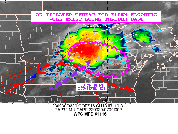
SUMMARY...Heavy showers and thunderstorms may continue to expand
in coverage a bit more over the next few hours before gradually
weakening after dawn. Some localized training of cells may produce
at least an isolated threat for runoff problems and flash flooding.

DISCUSSION...The GOES-16 IR satellite imagery has been showing an
increasing level of convective organization with the showers and
thunderstorms that were traversing areas of central and eastern MN
and are now advancing into northwest WI. The convection is
elevated in nature and is being driven by a low-amplitude
shortwave trough crossing the Upper Midwest in conjunction with a
well-defined frontal zone and nose of a 30 to 40 kt southwesterly
low-level jet out ahead of a surface low center.

PWs are on the order of 1.25 to 1.5 inches in connection with the
surge of stronger low-level jet energy, and there is a pool of
MUCAPE values of 500 to 1000 J/kg that should persist over the
next few hours in close proximity to a warm front draped across
areas of western and southern WI. This coupled with some very
modest shear profiles should tend to maintain the current MCS
activity going through dawn, with a gradual weakening trend
thereafter as the low-level jet begins to wane.

The 00Z HREF guidance has not had a particular good night in
handling this convection with some members tending to be underdone
and also too far northwest with their overall convective
footprint. The HRRR guidance in particular has been way underdone
with its QPF.

IR satellite imagery has been showing an uptick in cooling
convective tops over the last hour and reflective of some very
strong updrafts. Consequently, MRMS data has been showing an
increase in rainfall rates which are occasionally reaching 1.5+
inches/hour. The orientation of the convection ahead of the
surface low center and north of the warm front to its east
suggests some increased potential for some cell-training over the
next few hours as the activity crosses northwest WI and
potentially loses some latitude into areas of central WI.

Expect as much as 2 to 4 inches of rain along the path of the MCS
early this morning, and this may drive at least an isolated threat
for runoff problems and flash flooding. This will include some
urban flooding considerations.

Orrison

ATTN...WFO...ARX...DLH...GRB...MPX...MQT...

ATTN...RFC...NCRFC...NWC...

LAT...LON   46679111 46158924 45338842 44438883 44439064
            45289261 45999290 46559240
Last Updated: 445 AM EDT Sat Sep 30 2023
|


