| WPC Met Watch |
|
|
Mesoscale Precipitation Discussion: #1117 (2023) |
|
(Issued at 530 AM EDT Sat Sep 30 2023
) |
|
| MPD Selection |
|
|
|
|
|

Mesoscale Precipitation Discussion 1117
NWS Weather Prediction Center College Park MD
530 AM EDT Sat Sep 30 2023

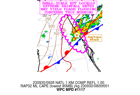
Areas affected...Portions of the FL Atlantic Coast

Concerning...Heavy rainfall...Flash flooding possible

Valid 300930Z - 301530Z

SUMMARY...Slow-moving showers and thunderstorms this morning with
locally extreme rainfall rates may produce some areas of flash
flooding.

DISCUSSION...The latest radar imagery has been showing an uptick
in very heavy shower and thunderstorm activity around the Daytona
Beach, FL area and extending offshore with some linear bands
becoming aligned with a convergent low-level flow regime just
north of a quasi-stationary frontal zone.

A very moist and unstable airmass is pooled across the region with
PWs that are running over 2 standard deviations above normal with
values of 2.25 to 2.5 inches. The 00Z RA0B sounding from KXMR
(Cape Canaveral) was reflective of a very deep and warm tropical
column with WBZ heights well over 15,000 feet and a PW of 2.31
inches. The latest RAP analysis shows MLCAPE values of 1500+ J/kg
along the coast and already indicative of a moderately unstable
airmass.

The combination of convergent low-level easterly flow, westerly
shear aloft, and this very moist and unstable airmass will support
slow-moving and locally anchored convective cells focusing along
and adjacent to the coast that will be capable of extreme rainfall
rates.

Some rainfall rates with the more organized convective cells this
morning will be capable of reaching 2 to 4 inches/hour and this
will also be connected to the fact there that is such a deep and
moist warm cloud layer.

The 06Z HREF guidance suggests a threat for localized storm totals
reaching or exceeding 5 inches where the storms become more
focused, and at least in the short-term, areas near Daytona Beach
will be most at risk for seeing these heavier totals. Going
through the morning hours, some additional expansion of convection
especially to the north along the coast may be possible.

Very high FFG values will certainly mitigate any flash flood
threat to an extent, but with such high rainfall rate potential
this morning, some flash flooding will be possible and especially
if any urban areas can get into the stronger convective cores.

Orrison

ATTN...WFO...JAX...MLB...

ATTN...RFC...SERFC...NWC...

LAT...LON   29878130 29828118 29598108 29228087 28808077
            28598080 28678113 29008136 29428154 29758153
Last Updated: 530 AM EDT Sat Sep 30 2023
|


