| WPC Met Watch |
|
|
Mesoscale Precipitation Discussion: #1132 (2022) |
|
(Issued at 916 PM EST Thu Nov 24 2022
) |
|
| MPD Selection |
|
|
|
|
|

Mesoscale Precipitation Discussion 1132
NWS Weather Prediction Center College Park MD
916 PM EST Thu Nov 24 2022

Areas affected...southern Louisiana, southern Mississippi, far
southwestern Alabama

Concerning...Heavy rainfall...Flash flooding possible

Valid 250214Z - 250814Z

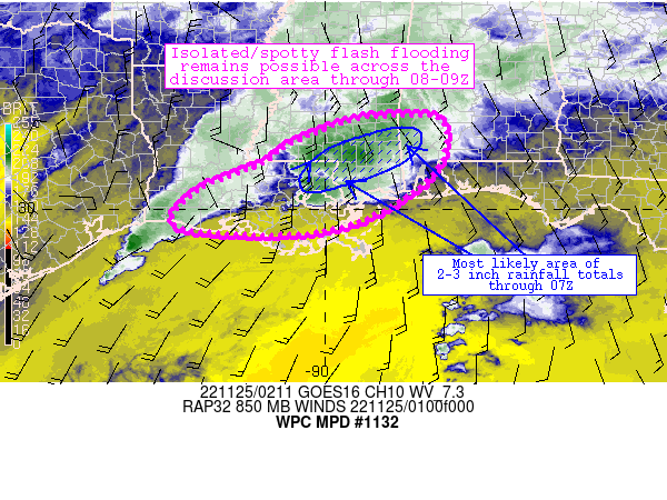
Summary...Areas of 2-4 inch rainfall totals are expected through
at least 07Z, but should result in localized/isolated flash flood
potential across the discussion area.

Discussion...An MCS has materialized along and just north of the
I-10/12 and US-84 corridors across southern Mississippi and
southern Louisiana.  The MCS was focused along strong 850mb
convergence in the region originating from confluent flow south of
the MCS and a warm front in the general vicinity.  Marginally
unstable conditions south of the front were helping to maintain
convection where convergence is maximized.  Additionally, the
orientation of the front (generally parallel to west-southwesterly
flow aloft) was allowing for training and repeating convection to
occur near the MCS.  Hourly rates of 1-2 inch/hr rainfall were
observed recently beneath the MCS (from Baton Rouge to
Franklinton), and 3-4 inch totals in 3 hours have also been noted.

The ongoing regime should result in a fairly narrow corridor of
2-3 inch rainfall totals (with spotty 4 inch amounts) extending
eastward from the ongoing MCS into southern Mississippi, with
somewhat lower totals potentially occurring closer to the New
Orleans Metro and coastal Mississippi.  These rainfall totals will
struggle to exceed FFG thresholds on a widespread basis, but may
be enough to cause localized ponding/runoff in sensitive areas and
low-lying spots.  The axis of peak low-level/850mb convergence
should shift slowly eastward into southwestern Alabama especially
after 07Z, with heavier precipitation expected to materialize in
those areas between 07-08Z.

Cook

ATTN...WFO...JAN...LCH...LIX...MOB...

ATTN...RFC...LMRFC...SERFC...NWC...

LAT...LON   31968805 31838751 31168749 30478799 29718937
            29479101 29649311 30399266 30969129 31359074
            31878938
Last Updated: 916 PM EST Thu Nov 24 2022
|


