| WPC Met Watch |
|
|
Mesoscale Precipitation Discussion: #1141 (2021) |
|
(Issued at 737 AM EST Mon Dec 06 2021
) |
|
| MPD Selection |
|
|
|
|
|

Mesoscale Precipitation Discussion 1141
NWS Weather Prediction Center College Park MD
737 AM EST Mon Dec 06 2021

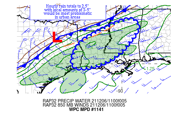
Areas affected...central MS, central LA, & extreme southeast TX

Concerning...Heavy rainfall...Flash flooding possible

Valid 061236Z - 061836Z

Summary...Pre-frontal convection with occasional training
character could lead to hourly rain totals to 2.5" and local
amounts of 3-5", which would be problematic in urban areas.

Discussion...An upper trough passing through the Midwest with an
incoming shortwave across OK and central TX have led to divergence
aloft and 1000-2000 J/kg of MU CAPE from western MS southwest into
southeast TX.  Precipitable water values in the region are
1.5-1.7" per GPS data and JAN/LCH raobs, which also show the
requisite deeply saturated profiles and fairly unidirectional flow
normally seen with possible training.  Effective bulk shear of
35-50 kts should continue to organize convective activity.  Radar
imagery recently shows backbuilding convection a bit ahead of a
cold front across central MS downstream of this instability pool.

The concern is that pre-frontal convection will attempt to
backbuild and train for a bit before the cold front can catch up
and sweep the activity southeast.  Eroding instability should
force heavy rain related issues southwest through the MPD area
with time.  While mesoscale guidance generally advertises local
amounts in the 3" range, places farther northeast in TN, KY, and
OH managed hourly rain totals to 2.5" with local 5" amounts where
mesocyclones managed to hold up convective progression, and see
little reason why similar wouldn't happen in MS, LA, and southeast
TX this morning where ingredients appear equally supportive.  Due
to recent dryness over much of the lower 48 over the past month,
soils are parched, so issues look most likely in urban areas.

Roth

ATTN...WFO...HGX...JAN...LCH...LIX...MEG...SHV...

ATTN...RFC...LMRFC...SERFC...WGRFC...NWC...

LAT...LON   33978962 33178862 30879041 29839257 29859441
            31999363
Last Updated: 737 AM EST Mon Dec 06 2021
|


