| WPC Met Watch |
|
|
Mesoscale Precipitation Discussion: #0117 (2020) |
|
(Issued at 1033 PM EDT Sat Mar 28 2020
) |
|
| MPD Selection |
|
|
|
|
|

Mesoscale Precipitation Discussion 0117
NWS Weather Prediction Center College Park MD
1033 PM EDT Sat Mar 28 2020

Areas affected...IN, northern KY into OH

Concerning...Heavy rainfall...Flash flooding likely

Valid 290232Z - 290730Z

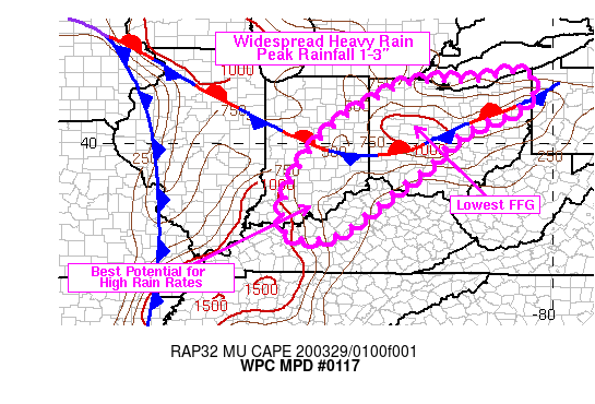
SUMMARY...Thunderstorms with rainfall rates up to 2 in/hr are
expected to move northeastward into northern KY, IN and OH through
08Z. Flash flooding is considered likely given antecedent
conditions and low flash flood guidance.

DISCUSSION...02Z radar imagery showed a cluster of thunderstorms
extending from central IN into western KY, with individual cell
movement toward the northeast at 50-60 kt. More cellular/discrete
convection was observed ahead of the main cluster in west-central
KY, with radar trends supporting rapid expansion in coverage.
Earlier rainfall rates (ending 01Z) along the IL/KY border were 1
to 1.5 inches in 30 minutes with estimated MLCAPE between
1000-1500 J/kg based on the SPC mesoanalysis page. While the best
instability has been located near and south of the OH River, flow
aloft is strongly diffluent with portions of the lower OH River
Valley situated within the right entrance region of a 160 kt jet
located at 200 mb.

Strong forcing for ascent will overspread IN/OH over the next few
hours as ongoing convection over central and southern IN moves
toward the northeast. The best potential for training of high
rainfall rates (peaking near 2 in/hr) will be south of a
stationary front analyzed west to east across IN and OH at 02Z,
given better access to instability. Along and north of the
stationary front, instability values are lower but 3 hour flash
flood guidance values are fairly low with values ranging from 0.75
inches to 1.5 inches.

While the initial cluster translating northeastward through IN/OH
will pose a flash flood threat, additional convection developing
to the south will also quickly track toward the northeast with a
broad portion of eastern IN, northern KY into OH seeing an
enhanced threat for flash flooding given wet antecedent
conditions.

Otto

ATTN...WFO...CLE...ILN...IND...IWX...LMK...PAH...PBZ...

ATTN...RFC...OHRFC...

LAT...LON   41868107 41788066 41638053 41268055 40858105
            40368229 39538316 38978389 38348468 37578582
            37688699 38808690 40098608 40918505 41478401
            41658290 41628211 41788140
Last Updated: 1033 PM EDT Sat Mar 28 2020
|


