| WPC Met Watch |
|
|
Mesoscale Precipitation Discussion: #0143 (2020) |
|
(Issued at 1131 AM EDT Mon Apr 13 2020
) |
|
| MPD Selection |
|
|
|
|
|

Mesoscale Precipitation Discussion 0143
NWS Weather Prediction Center College Park MD
1131 AM EDT Mon Apr 13 2020

Areas affected...Central/Northern VA...Central/Eastern
MD...DC...Eastern PA...Southeast NY...NJ...Northern DE...

Concerning...Heavy rainfall...Flash flooding possible

Valid 131530Z - 132000Z

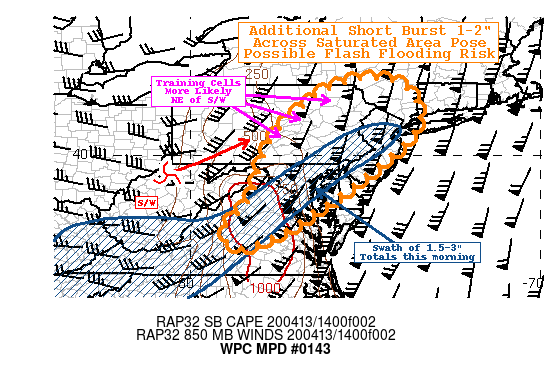
SUMMARY...Another round of strong thunderstorms with hourly rates
exceeding 1" moving across areas saturated this morning pose
threat for possible flash flooding.

DISCUSSION...GOES-WV suite denotes a very strong large scale
cyclone across the Eastern third of the US, with a compact
enhanced shortwave moving along the E OH/W WV border lifting
northeast.   A large cirrus shield indicative of extremely strong
flow aloft, but also the main axis of deep layer atmospheric
river/warm conveyor belt, that depicts total precipitable water
values over 1.75".  This corridor/moisture axis was prolific this
morning producing a wide swath of 1.5-3" totals extending from
central VA through the DC/Baltimore/Philadelphia metro, with some
1-1.5" totals through the NYC metro into SE CT.  This area already
has natural low FFG values (generally below 1"/hr), which has
likely reduced further.

However, this moisture axis is pressing east, and the GOES-WV
shows a well defined dry slot pressing eastward, though with some
residual low level moisture lingering (slightly backed low level
flow) with surface Tds still in the mid-60F.  Still, an hour or so
of more direct solar heating has already brought temps near 70 and
with some steepening lapse rates, instability has built back in.
Further heating and warm advection ahead of the height-falls
crossing the terrain suggest in the next few hours or so, with
SBCAPEs of 1500-2000 J/kg.   This will clearly lead to a severe
weather threat that is denoted well in the MCD 381 issued by SPC.
So with solid low level moisture and strong, broadening updrafts,
should also support rainfall generation and support rain rates in
excess of 1.5-2/hr.  Duration is likely to be short given the
strength of the steering flow, limiting overall totals; however,
hi-res CAMs suggest the potential of hourly 1.25"/hr totals
especially if cells are: 1) supercellular and slow due to the
rotation relative to the flow or 2) are further north across
central PA, closer to shortwave itself where steering flow is more
unidirectional supporting some short-term/cross-tracks before the
main shortwave pushes through (after 18z) and mid-level flow
veers.

The supercellular nature is more likely south and east across
areas (I-95 corridor) that received the 1.5-3" earlier and so the
quick rates over flooded/saturated areas may pose flash flooding
there.  However, training with up to 2" combined with precursory
orographic ascent (especially as the flow becomes more orthogonal
to the terrain across the Poconos/Catskills) also pose possible
flash flooding concerns as well.

Gallina

ATTN...WFO...AKQ...ALY...BGM...CTP...LWX...OKX...PHI...RNK...

ATTN...RFC...MARFC...NERFC...

LAT...LON   42147427 41727369 41147345 40437380 39077544
            38257667 37927716 37357854 37837902 38777827
            40377770 41507662 42067556
Last Updated: 1131 AM EDT Mon Apr 13 2020
|


