| WPC Met Watch |
|
|
Mesoscale Precipitation Discussion: #0017 (2021) |
|
(Issued at 121 AM EST Thu Jan 28 2021
) |
|
| MPD Selection |
|
|
|
|
|

Mesoscale Precipitation Discussion 0017
NWS Weather Prediction Center College Park MD
121 AM EST Thu Jan 28 2021

Areas affected...Central /Southern California Coastal Ranges

Concerning...Heavy rainfall...Flash flooding likely

Valid 280615Z - 281815Z

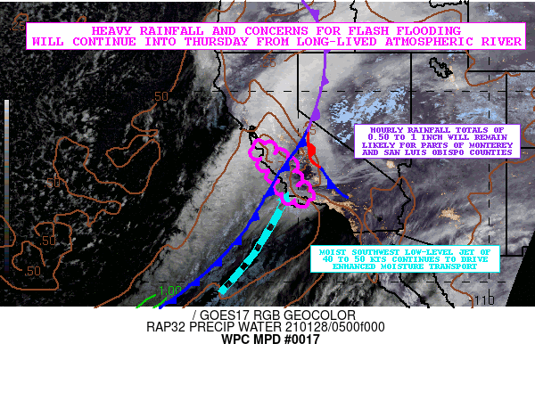
SUMMARY...A relatively long-lived atmospheric river continues to
pummel the coastal ranges of central California with very heavy
rainfall and especially over the Santa Lucia range south of
Monterey Bay. Gradually the axis of heaviest rainfall will be
settling down the coast and closer into the Transverse Ranges of
southern California on Thursday. The heavy rainfall is expected to
result in areas of urban flooding, and maintain an elevated threat
of flash flooding in and around the more sensitive burn scar
locations.

DISCUSSION...The latest GOES-17 GeoColor RGB satellite imagery and
suite of WV/IR channels continue to show a robust atmospheric
river advancing across a large area of central California as a
deep upper trough just off the West Coast pivots very slowly off
to the east along with a surface cold front. This again is driving
a plume of moist deep-layer southwest flow into the coastal ranges
with PWs generally near 1 inch. Compared to this time last night,
the low-level jet is just a tad weaker, but is still on the order
of 40 to 50 kts, and that is still resulting in moderately high
IVT values of 500 to 750 kg/m/s.

The strongest IVT values remain pegged in across areas of southern
Monterey county and northern San Luis Obispo county where already
storm total rainfall amounts of near 10 inches have been reported
locally in the Santa Lucia mountains. The aforementioned front
associated with this atmospheric river was largely stalled out
throughout the afternoon and evening, but within the last few
hours has begun to drift down to the southeast as the deeper layer
trough axis begins to move off to the east.

Going through the 12Z (4AM PST) time frame, the 00Z HREF suite of
guidance suggests heavy rainfall rates with hourly totals of 0.50
to occasionally near 1 inch will continue along the front. This
will unfortunately exacerbate ongoing areal flooding concerns, and
will maintain an elevated threat for more flash flooding across
the burn scar areas. This will include the Carmel/River and Dolan
scars of Monterey county. Somewhat lesser rainfall rates are
expected farther inland, but some 0.50"/hour amounts will be
possible also across the Diablo Range as well and noting possible
concerns with the Mineral burn scar in Fresno county.

In the 12Z to 18Z time frame, the heaviest rains should largely be
focused over San Luis Obispo county and also edging down into the
Transverse Ranges of Santa Barbara county and possibly Ventura
county. The IVT values are expected to weaken somewhat in this
time frame, and the cold front will be making progress down the
coast, but hourly rainfall totals are still likely to exceed a
0.50 inch over the southwest facing terrain.

Expect additional rainfall amounts going through 18Z (10AM PST) to
be on the order of 3 to 5 inches with isolated heavier amounts.
This means that portions of southern Monterey county and northern
San Luis Obispo county will be looking at storm total amounts
potentially exceeding 15 inches!

The Transverse Ranges of southern California have largely escaped
this event so far, but expect heavy rains to be arriving in
earnest between 12Z and 18Z time frame, and there may be concerns
with the Cave burn scar in the foothills of the Santa Ynez
mountains outside of Santa Barbara by late morning.

In addition to the ongoing concerns for urban flooding, and flash
flooding relating to the burn scars, there will remain the threat
of mudslides and debris flows as this atmospheric river event
continues.

Orrison

ATTN...WFO...HNX...LOX...MTR...

ATTN...RFC...CNRFC...NWC...

LAT...LON   37332206 37252174 37062153 36852144 36512066
            36112030 35752020 35262011 34941997 34711922
            34431915 34251950 34362055 34642082 35052081
            35352110 35672129 35852157 36192185 36482197
            36852206 37122236
Last Updated: 121 AM EST Thu Jan 28 2021
|


