| WPC Met Watch |
|
|
Mesoscale Precipitation Discussion: #0178 (2023) |
|
(Issued at 1133 AM EDT Wed Apr 12 2023
) |
|
| MPD Selection |
|
|
|
|
|

Mesoscale Precipitation Discussion 0178
NWS Weather Prediction Center College Park MD
1133 AM EDT Wed Apr 12 2023

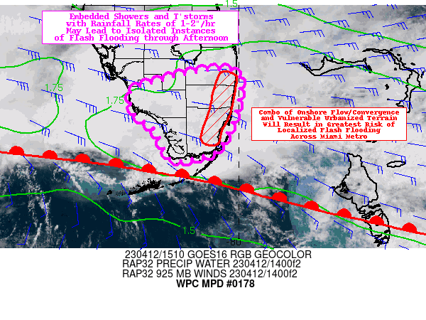
Areas affected...South Florida

Concerning...Heavy rainfall...Flash flooding possible

Valid 121530Z - 122130Z

Summary...Widespread rainfall with embedded showers and
thunderstorms will support localized rainfall rates of 1-2"/hr
through much of the afternoon. Isolated instances of flash
flooding are possible, mainly over the Miami metro area.

Discussion...Stratiform rainfall coverage has been gradually
increasing across south-central Florida this morning, and more
recently embedded showers and thunderstorms are also increasing in
coverage. The most impressive of these discrete cells have been
ongoing near and north of the Florida Keys, and slow deviate
motions have been observed towards the east-northeast with an
established right-moving supercell north of the Lower Keys.
Otherwise, embedded shower and thunderstorm motion has generally
favored a more northwest to northerly track in line with the 0-2
km mean wind (on the order of 15-20 kts). All of this convection
is situated along and north of a frontal zone, which appears to be
slowly lifting north as a warm front as of this morning. The
mesoscale environment along and ahead of this frontal zone is
characterized by precipitable water values of 1.7-1.9 inches (near
the max moving average per MFL/KEY sounding climatology), ML CAPE
of 500-1500 J/kg, and 0-3 km bulk shear of 15-25 kts. Moderate
moisture transport from the east is occurring in the lower levels
of the troposphere (mostly focused at 925 mb), and this onshore
flow along the Gold Coast may help to enhance convective activity
in and around the Miami metro this afternoon.

The CAM guidance with regard to QPF has been rather dispersed
since the overnight 00z cycle, but the 12z HREF has come into some
better agreement that has increased confidence a bit for the
afternoon forecast. The HRRR has remained the largest consistent
outlier overall, initially failing to meaningfully initiate the
convection that has occurred in and around the FL Keys, but has
since done a modestly better job assimilating and propagating this
convection. Farther northeast along the Gold Coast, the HRRR has
been the most persistent in developing deep convection with the
depiction of rainfall rates as high as 2-3"+/hr (which has so far
failed to materialize). There is still quite a good bit of
skepticism concerning the development of deep convection with
rates this high, but the 12z ARW and NAM-nest have hints of this
potential in the vicinity of the Gold Coast through 21z. The
environment could support these rates should deep convection
develop, but it appears more likely that embedded showers and
thunderstorms will remain capped closer to 10-12k feet (with a
distinct thermal cap largely preventing updrafts from accelerating
much above this level). Even so, wet bulb zero heights are near
this 10-12k ft height which will support highly efficient warm
rain processes with 1-2"/hr rates easily being realized. Since
these rates may be concentrated along the Gold Coast where
low-level frictional convergence will be maximized (with the
potential for some repeating/training), any localized instances of
flash flooding are most likely across the Miami metro area (where
urbanized terrain is also most likely to result in excessive
runoff).

Churchill

ATTN...WFO...MFL...

ATTN...RFC...SERFC...NWC...

LAT...LON   26588048 26528002 26238000 25798008 25268038
            25138081 25138114 25588136 25888172 26248176
            26428121
Last Updated: 1133 AM EDT Wed Apr 12 2023
|


