| WPC Met Watch |
|
|
Mesoscale Precipitation Discussion: #0179 (2023) |
|
(Issued at 530 PM EDT Wed Apr 12 2023
) |
|
| MPD Selection |
|
|
|
|
|

Mesoscale Precipitation Discussion 0179
NWS Weather Prediction Center College Park MD
530 PM EDT Wed Apr 12 2023

Areas affected...South Florida

Concerning...Heavy rainfall...Flash flooding likely

Valid 122130Z - 130200Z

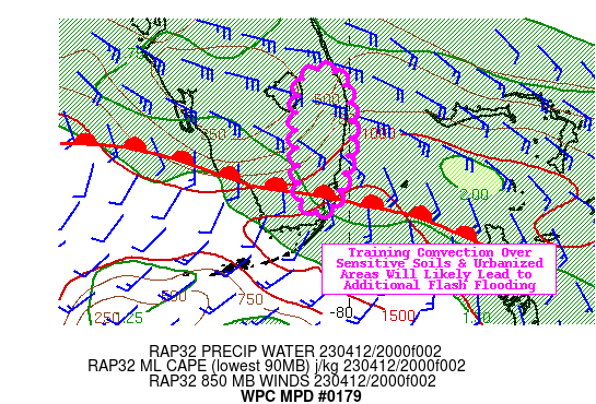
SUMMARY...Additional rounds of thunderstorms in the heavily
urbanized corridor of South Florida, where 2-6" of rainfall have
fallen since this morning, is susceptible to additional flash
flooding through the evening rush hour.

DISCUSSION...Doppler radar continues to detect areas of organized
convection from Homestead on north to the Fort Lauderdale area.
Surface observations as of 21Z show winds shifting from the ENE to
the SE between Key Largo and Miami, indicating the warm front is
continuing its steady progression north through South Florida. SPC
mesoanalysis shows MLCAPE between 750-1,500 J/kg and PWs between
1.8-1.9" available for areas of convection. Latest 20Z RAP also
shows a highly saturated profile (>90% RH at low-mid levels), a
classic skinny CAPE profile, warm cloud layer depths of 11,000
kft, and effective bulk wind shear values >30 knots. These
parameters indicate organized convection along the warm front will
be continue to maintain efficient warm rain processes for at least
a few more hours.

Since 8AM this morning, portions of Miami-Dade and Broward
counties have received anywhere from 2-6" of rainfall. These
counties remain out ahead of the approaching warm front and given
the parameters listed above, the combination of the Miami-Fort
Lauderdale metro areas recent rainfall and high concentration of
hydrophobic surfaces make them quite vulnerable to additional
flash flooding. The warm front will progress faster to the north
later this evening and drier/warmer air within the 700-300mb layer
will lead to diminishing convection. This could, however, then
place the ongoing area of active convection closer to Boca Raton
and West Palm Beach, where they also dealt with bouts of rainfall
earlier today. This will give the Miami a much needed break, but
not before a few more hours of thunderstorms that should produce
additional flash flooding through 02Z.

Mullinax

ATTN...WFO...MFL...MLB...

ATTN...RFC...SERFC...NWC...

LAT...LON   27168056 27138010 26317999 25468023 25488058
            26118067 26628068
Last Updated: 530 PM EDT Wed Apr 12 2023
|


