| WPC Met Watch |
|
|
Mesoscale Precipitation Discussion: #0180 (2021) |
|
(Issued at 1015 AM EDT Sun May 16 2021
) |
|
| MPD Selection |
|
|
|
|
|

Mesoscale Precipitation Discussion 0180
NWS Weather Prediction Center College Park MD
1015 AM EDT Sun May 16 2021

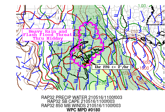
Areas affected...Middle Texas Coast into South-Central Texas

Concerning...Heavy rainfall...Flash flooding possible

Valid 161414Z - 161914Z

Summary...Localized flash-flood threat over eastern portions of
south-central Texas to the middle Texas coast through midday.

Discussion...Three distinct multi-cell clusters of activity have
developed over south-central TX/middle TX coast this morning with
a connection developing between southeastward moving activity
centered south of San Antonio and northward moving activity
centered north of Matagorda Bay. 20 to 25kt southerly 850mb flow
bringing 2" PW air (2.5 standard deviations above normal) from the
lower TX coast (per 12Z KCRP and KBRO raobs) will generally
increase to 30kt over the next few hours ahead of a mid-level
impulse over north TX. Ample surface-based instability with SBCAPE
2000 to 2500 J/Kg per recent RAP runs will be renewed in this
southerly low level flow. Light southwesterly steering flow will
continue to make for slow storm motion with particularly heavy max
rain rates expected to continue. Past hour rainfall estimates from
KEWX and KHGX as well as mesonet rain gauge measurements have
locally reached 2 to 3 inches.

Development is expected to generally lift/develop north through
midday along with moisture/instability axis between Austin and the
Houston metro areas with further north TX development this
afternoon with the mid-level impulse. A large area of FFG below
2"/hr is ahead of the western side of the activity from heavy
rainfall yesterday making for a more enhanced there toward CRP.
However, the slow storm motion and heavy rain rates should
continue to locally exceed the higher FFG to the north which is
generally 3"/hr making for a large area of possible flash flooding
into the early afternoon.

Jackson

ATTN...WFO...BRO...CRP...EWX...FWD...HGX...

ATTN...RFC...WGRFC...NWC...

LAT...LON   30959669 29749625 28759580 28239656 27549711
            27099751 28129872 28959783 29359778 30799778
Last Updated: 1015 AM EDT Sun May 16 2021
|


