| WPC Met Watch |
|
|
Mesoscale Precipitation Discussion: #0202 (2020) |
|
(Issued at 349 AM EDT Sat May 16 2020
) |
|
| MPD Selection |
|
|
|
|
|

Mesoscale Precipitation Discussion 0202
NWS Weather Prediction Center College Park MD
349 AM EDT Sat May 16 2020

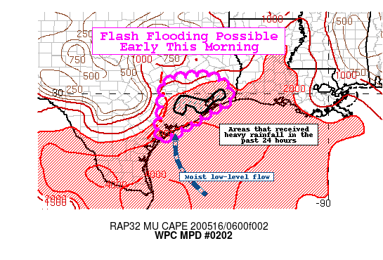
Areas affected...Texas Gulf Coast

Concerning...Heavy rainfall...Flash flooding possible

Valid 160749Z - 161349Z

Summary...An approaching line of thunderstorms producing heavy
rainfall along the Texas Gulf Coast will be capable of flash
flooding early this morning. Rainfall totals of 2-4" with locally
higher amounts will be possible.

Discussion...Regional radar as of 08Z showed an eastward moving
line of organized convection approaching the Texas Gulf Coast.
Recent mesonet observations around CRP showed 2-2.5" hourly totals
as the line progresses eastward. Recent IR imagery from GOES-East
indicated this activity remains intense with cooling cloud tops.
This activity has been working on a more than sufficient
environment characterized by increasing PWs approaching 2" with a
MUCAPE gradient (4000 J/kg across far southern TX to around 2000
J/kg around Houston). Aloft, the weak mid-level shortwave working
across Texas will continue to help provide the weak but notable
large scale forcing.

Hi-res guidance has been poorly handling the evolution of this
line, but a consensus of the better performing models show
potential for additional amounts of 2-4" possible with some
locally higher amounts 4-5". The 00Z NSSL WRF and 06Z HRRR seemed
to have a good handle on the latest radar trends and were leaned
on for the outlook area. The 00Z HREF probabilities appear useful
showing moderate percentages of 2"+ in 1-hour (40-60 percent) and
a slight signal for 3" in 1-hr around the Houston metro area.
Similarly, there are high probabilities for 3"+ in the 6-hours
ending 15Z for many areas along the TX Gulf Coast.

Extrapolation of the current line and the more than sufficient
environmental conditions suggest there should continue to be a
flash flood threat early this morning. Especially vulnerable areas
include urban areas and locations that picked up several inches of
rain yesterday and subsequently have lower FFGs.

Taylor

ATTN...WFO...CRP...EWX...HGX...LCH...

ATTN...RFC...WGRFC...NWC...

LAT...LON   30659573 30649465 29859400 29189501 28649586
            28179690 29359675 30359665
Last Updated: 349 AM EDT Sat May 16 2020
|


