| WPC Met Watch |
|
|
Mesoscale Precipitation Discussion: #0217 (2023) |
|
(Issued at 216 PM EDT Sun Apr 30 2023
) |
|
| MPD Selection |
|
|
|
|
|

Mesoscale Precipitation Discussion 0217
NWS Weather Prediction Center College Park MD
216 PM EDT Sun Apr 30 2023

Areas affected...Portions of the Mid-Atlantic Coastal Plain

Concerning...Heavy rainfall...Flash flooding possible

Valid 301815Z - 010015Z

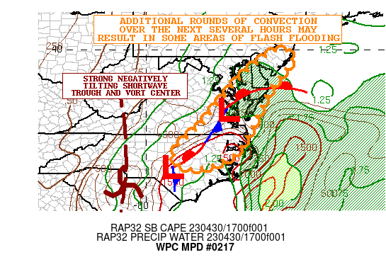
SUMMARY...Additional rounds of heavy showers and thunderstorms
arriving across the coastal plain of the Mid-Atlantic coupled with
relatively moist/wet antecedent conditions may result in some
instances of flash flooding.

DISCUSSION...The latest surface analysis shows multiple waves of
low pressure riding northeast up along a frontal zone draped
across the coastal plain of the Mid-Atlantic along with
corresponding shortwave support aloft. The lead wave is advancing
across the Hampton Roads area of southeast VA currently with a
relatively concentrated, but somewhat progressive axis of
convection exiting toward the lower Delmarva. Meanwhile, a second
and more dominant wave of low pressure with stronger
forcing/energy aloft is getting ready to exit eastern SC and lift
up across eastern NC.

Radar imagery is showing a gradually expanding area of convection
with the more dominant southerly wave and this energy should favor
an expansion and redevelopment of convection off to the northeast
across areas of central to northeast NC, and into southeast VA
going through the mid to late-afternoon hours.

In fact, the latest hires model guidance shows this energy taking
on a negative tilt as it lifts up across the Mid-Atlantic coastal
plain this afternoon, and the strong DPVA/forcing associated with
this coupled with instability recovery and favorable shear
profiles in the wake of the lead wave should favor rather
widespread convection with heavy rainfall rates.

The 12Z HREF guidance shows high probabilities for seeing 1 to 2
inch/hour rainfall rates impacting areas of central to northeast
NC and southeast VA in particular with some potential for
additional rainfall amounts of 2 to 4 inches. The NAM-Conest
actually supports isolated 5 to 6 inches of rain given some
concerns for locally training convective cells along the
aforementioned front.

A combination of both the lead wave and the dominant secondary
wave will also eventually impact areas of the Delmarva and
southern NJ late this afternoon and into the early evening hours.
Additional rainfall amounts here may also reach as much as 2 to 3
inches with locally higher amounts.

Given the already moist/wet antecedent conditions and expectation
of seeing additional rounds of convection over the next few hours,
there should be a threat of seeing some instances of flash
flooding.

Orrison

ATTN...WFO...AKQ...LWX...MHX...PHI...RAH...

ATTN...RFC...MARFC...SERFC...NWC...

LAT...LON   39917481 39887417 39467418 38507497 37717536
            36037623 35337734 35257844 35887885 37027768
            38197674 39197579
Last Updated: 216 PM EDT Sun Apr 30 2023
|


