| WPC Met Watch |
|
|
Mesoscale Precipitation Discussion: #0250 (2019) |
|
(Issued at 357 AM EDT Sat May 18 2019
) |
|
| MPD Selection |
|
|
|
|
|

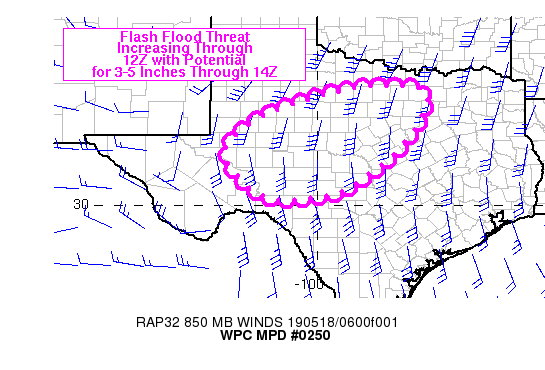
Mesoscale Precipitation Discussion 0250
NWS Weather Prediction Center College Park MD
357 AM EDT Sat May 18 2019

Areas affected...west-central to north-central TX

Concerning...Heavy rainfall...Flash flooding possible

Valid 180756Z - 181355Z

Summary...A rapid expansion of convection is expected across
west-central TX this morning with an evolution toward a flash
flood threat. Training rainfall with rates peaking between 2-3
in/hr will be possible along with storm total rainfall between 3-5
inches through 14Z.

Discussion...Over the past hour, regional radar imagery across
western TX showed an increase in the coverage of convection
stretching from near INK to just south of SJT. Recent cloud top
warming had been observed on GOES 17 1-minute infrared imagery,
associated with a discrete supercell south of SJT which is likely
weakening as it enters into a more strongly capped environment.
However, the leading edge of a AZ/NM shortwave within the base of
a large closed low over the Great Basin is being felt across the
Permian Basin as cooling in the 850-700 mb layer allows eroding of
a capping inversion observed on the 00Z DRT sounding. 850 mb winds
were 35-45 kt from the south per recent VAD wind data from KMAF,
KSJT and KDFX, which has been helping to increase precipitable
water values to near 1.5 inches as seen on blended TPW imagery as
far west as a SJT to SPS line as of 05Z.

As the shortwave trough axis continues to advance east over the
next 6 hours, convective coverage is expected to expand over
western portions of the MPD threat area, with an overall movement
toward the east and northeast with the 850-300 mb mean wind. A
flash flood threat is expected to develop if a cold pool forms on
the south side of the expanding convection, with moderate strength
850 mb flow intersecting the boundary, allowing for storms to
train off to the ENE with the mean flow. The environment is
supportive of heavy rainfall rates with 2-3 in/hr possible

While the hi-res models have been nearly unanimous in depicting a
swath of heavy rain across west-central TX through 12Z, they have
struggled with the timing. However, now that storms have formed,
confidence is increasing for the development of flash flooding,
with current thinking that 09Z-12Z will be when runoff becomes a
bit more widespread.

Otto

ATTN...WFO...EWX...FWD...LUB...MAF...SJT...

ATTN...RFC...WGRFC...

LAT...LON   33419808 33349713 32979685 31919739 30879854
            30309956 30200124 30820226 31640258 32510160
            33040012 33319911
Last Updated: 357 AM EDT Sat May 18 2019
|


