| WPC Met Watch |
|
|
Mesoscale Precipitation Discussion: #0349 (2021) |
|
(Issued at 1200 AM EDT Sat Jun 19 2021
) |
|
| MPD Selection |
|
|
|
|
|

Mesoscale Precipitation Discussion 0349
NWS Weather Prediction Center College Park MD
1200 AM EDT Sat Jun 19 2021

Areas affected...Central Illinois, Central and Southern Indiana,
Southwest Ohio, Northern Kentucky

Concerning...Heavy rainfall...Flash flooding likely

Valid 190359Z - 190900Z

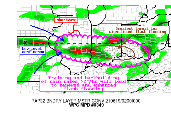
Summary...Showers and thunderstorms developing along a low-level
confluence axis will continue to expand in coverage and train
through the overnight. Intensifying rainfall rates will likely
exceed 2"/hr at times. Backbuilding of these thunderstorms may
lead to nearly stationary cells, and an additional 2-4" of
rainfall is expected, with local amounts to 6" possible. Flash
flooding is likely, some of which could be significant.

Discussion...GOES-E IR imagery and the regional radar mosaic
indicate deepening clusters of thunderstorms expanding from
central Iowa southeast through eastern Kentucky this evening.
These storms are developing ahead of a surface cold front and
along a low-level confluence boundary at the nose of the
intensifying LLJ, with additional ascent being provided by subtle
mid-level shortwaves.

The thermodynamics across the region are extremely favorable for
heavy rainfall, with further enhancement likely through the night.
Recent GPS observations indicate a corridor of 1.75" PWs in the
pre-convective environment, well above the climatological 90th
percentile, and nearing daily records. Freezing levels on the 00Z
U/A soundings were approaching 14,000 ft, indicating warm rain
processes, with mid-level lapse rates near moist adiabatic levels
contributing to MUCape analyzed by the recent RAP to be 2000-4000
J/kg, highest SW of the main convective clusters. This higher
instability will continue to be drawn northeastward on inflow
approaching 40 kts on local VWPs, fueling a continuation and
expansion of thunderstorms overnight.

Ahead of the front exists a low-level confluence axis, enhanced by
convective outflows across OH/IN/IL. As the evening progresses and
the LLJ intensifies, isentropic ascent of this feature combined
with modest PVA ahead of the subtle shortwaves should lead to
further development and intensification of convection. While the
mean 850-300mb flow is likely to persist near 30 kts, this should
become even better aligned to the boundary, suggesting training of
echoes. More concerning, however, is that as the LLJ evolves, the
propagation vectors become increasingly anti-parallel to this mean
flow driving Corfidi vectors which are forecast by the RAP to fall
below 5 kts across parts of IN and OH. With rain rates progged to
exceed 2"/hr according to HREF probabilities, these nearly
stationary storms could produce significant flash flooding as 2-4"
of rainfall occurs in a short period of time. Locally, 6" of
rainfall is possible in some locations where slow moving or
repeated convection occurs.

Although 7-day rainfall has been below normal leading to dry 40cm
soils according to NASA SPoRT, this does not account for
significant rainfall that has already occurred tonight. Further,
rainfall rates of this intensity can quickly overwhelm even dry
soils so flash flooding is likely, and may become significant in a
few areas.


Weiss

ATTN...WFO...DVN...ILN...ILX...IND...JKL...LMK...LOT...LSX...
PAH...RLX...

ATTN...RFC...NCRFC...OHRFC...NWC...

LAT...LON   40598943 40538836 40378626 40238483 40028381
            39708316 39258250 38848246 38468268 38238299
            38018461 38198617 38388755 38628905 38969020
            39229050 39709070 40149061 40519027
Last Updated: 1200 AM EDT Sat Jun 19 2021
|


