| WPC Met Watch |
|
|
Mesoscale Precipitation Discussion: #0487 (2020) |
|
(Issued at 707 PM EDT Tue Jul 14 2020
) |
|
| MPD Selection |
|
|
|
|
|

Mesoscale Precipitation Discussion 0487
NWS Weather Prediction Center College Park MD
707 PM EDT Tue Jul 14 2020

Areas affected...Northeast Kansas...Much of Iowa into Southwest
Wisconsin

Concerning...Heavy rainfall...Flash flooding possible

Valid 142306Z - 150500Z

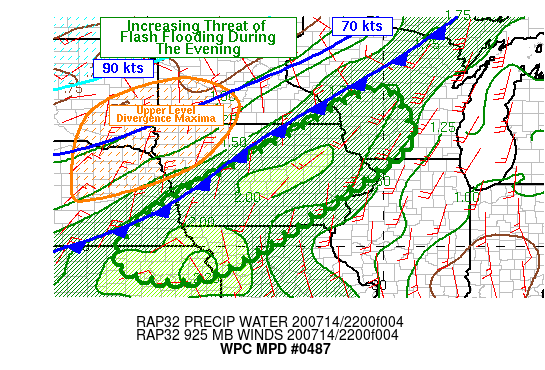
Summary...There will be an increasing risk of flash flooding
through the late afternoon and during the evening hours as
thunderstorms become more numerous.  These storms will likely be
capable of producing localized rainfall rates of 2 or more inches
per hour and total rainfall of 2-5" with locally higher amounts.

Discussion...The area from eastern Iowa northeastward into
Wisconsin will be in an increasingly favorable area for storms
that will be able to produce heavy rainfall as a cold front
approaches from the north/west, southerly flow ahead of the front
draws deep moisture in place and upper level divergence associated
with an upper level jet approaches from the northwest.

HREF probabilities of 1 hour QPF exceeding 2 inches increases to
roughly 30 percent by 03Z...with the highest probabilities from
northeast Kansas into central Iowa where low level flow will be
increasing with the approach of sunset. With satellite-derived TPW
values already at or above 2 inches and SB/ML CAPE already of 5000
J per kg, the HREF probabilities seem reasonable.  Synoptic scale
upper level divergence will increase as the axis of a 90+ kt upper
level jet rotates around the base of a broad-scale trough during
the evening.  Given the interaction between the synoptic scale
forcing and any storm-generate boundaries, the focus for heaviest
rain should shift south and west with time...reaching northeast
Kansas by mid- to late-evening.

Cells which have been forming during the late afternoon in
southern Iowa have been progressive enough, but with low level
flow forecast to back with time, slower cell motions are expected
for a period of time which allows rainfall totals of 2 to 4 inches
with locally higher amounts possible.

Additional storms should form along and ahead of the front in
northeast Iowa and adjacent portions of Wisconsin.  HREF
probabilities of 1- and 2- inches per hour are not as robust as
areas to the southwest but the potential for excessive rainfall
remains in the event storms happen to repeat or train over the
same areas.

This could create new areas of flash flooding...or worsen any
on-going flooding from earlier in the day...into the evening.

Bann

ATTN...WFO...ARX...DMX...DVN...EAX...GRB...MKX...OAX...TOP...

ATTN...RFC...MBRFC...NCRFC...NWC...

LAT...LON   44389044 44058957 43018927 42528986 41689096
            39219496 39459749 40859669 42939307
Last Updated: 707 PM EDT Tue Jul 14 2020
|


