| WPC Met Watch |
|
|
Mesoscale Precipitation Discussion: #0521 (2021) |
|
(Issued at 726 PM EDT Mon Jul 12 2021
) |
|
| MPD Selection |
|
|
|
|
|

Mesoscale Precipitation Discussion 0521
NWS Weather Prediction Center College Park MD
726 PM EDT Mon Jul 12 2021

Areas affected...Portions of the Northern Mid-Atlantic...Far
Southeast NY and Long Island

Concerning...Heavy rainfall...Flash flooding likely

Valid 122325Z - 130525Z

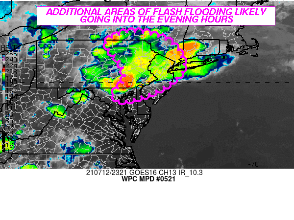
SUMMARY...Additional flash flooding likely going through the
evening hours as focused areas of very heavy showers and
thunderstorms continue and locally train/repeat over the same
area.

DISCUSSION...The latest satellite and radar imagery continues to
show areas of strong convection across areas of the northern
Mid-Atlantic region early this evening with one area of emphasis
over areas of northeast MD, southeast PA, and southwest NJ.
Another area of focus is over parts of northeast PA and northern
NJ. In both areas, strong convection has been focusing in response
to enhanced surface moisture convergence and with proximity to
enhanced boundary layer moisture and instability.

The activity farther south over areas of southeast PA and
southwest NJ has already been responsible for extreme flash
flooding conditions within parts of the Philadelphia metropolitan
area and the adjacent suburbs of southwest NJ where backbuilding
and repeating areas of convection along an earlier well-defined
mesoscale boundary has generated as much as 8 to 11 inches of rain
over since mid-afternoon. More recently, some of this same axis of
convection has tended to settle farther southwest into areas of
northeast MD to the northeast of Baltimore, and there is already
additional signals for training and repeating convective cells
across this area.

Expect there to be additional heavy rainfall amounts of as much as
3 to 5 inches locally with the ongoing organized convection
impacting areas of northeast MD, southeast PA, and southwest NJ
going through 03Z. This will be facilitated by hourly rainfall
amounts alone that could approach or exceed 2.5 inches.

Meanwhile, along a quasi-stationary front across north-central to
northeast PA, and into far northern NJ, there is likely to be a
focus for concentrated convection here persisting through the
late-evening time frame, and including the greater New York City
metropolitan area. This will be in response to the stronger
convergence and pool of instability/moisture along the
aforementioned frontal zone. Localized orographic forcing near the
Poconos will also be a factor in enhancing the rainfall potential.
Some areas may see as much as 2 to 4 inches across this region,
with isolated heavier amounts possibly reaching 5 inches.

Additional areas of flash flooding are likely, and especially with
respect to the ongoing high-impact event near and adjacent to the
Philadelphia metropolitan area, where any additional rains will
only worsen the ongoing life-threatening flash flooding situation.

Orrison

ATTN...WFO...ALY...BGM...CTP...LWX...OKX...PHI...

ATTN...RFC...MARFC...NERFC...NWC...

LAT...LON   42407565 42117456 41697389 41207362 40667350
            40147395 39817441 39357542 39107642 39277679
            39547679 40087630 40537635 41047654 41637708
            41927719 42297653
Last Updated: 726 PM EDT Mon Jul 12 2021
|


