| WPC Met Watch |
|
|
Mesoscale Precipitation Discussion: #0626 (2020) |
|
(Issued at 940 AM EDT Thu Aug 13 2020
) |
|
| MPD Selection |
|
|
|
|
|

Mesoscale Precipitation Discussion 0626
NWS Weather Prediction Center College Park MD
940 AM EDT Thu Aug 13 2020

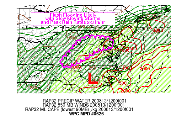
Areas affected...southern MD into northern/central/western VA

Concerning...Heavy rainfall...Flash flooding likely

Valid 131339Z - 131930Z

SUMMARY...Slow moving storms with a very moist environment should
produce a few areas of scattered flash flooding from southern MD
into portions of VA over the next several hours. Peak rainfall
rates of 2-3 in/hr are expected with 6 hour rainfall totals
between 2-4 inches. Given saturated soils, flash flooding is
considered likely.

DISCUSSION...Recent radar imagery showed disorganized but slow
moving showers and thunderstorms over northern VA into D.C. and
central/southern MD. 12Z observations showed a moist environment
in place across the Mid-Atlantic region with precipitable water
values over 2 inches from the Delmarva into MD and central VA. 12Z
RAOB data indicated wet bulb zero heights of 12 to 14 kft AGL from
WAL to RNK with 500-1500 J/kg MLCAPE which will help to support
warm rain processes. Farther south, an 850 mb low was analyzed
over eastern NC with southeasterly to easterly flow located to its
north over VA. Deep layer mean flow across most of the region was
weak, averaging 5-10 kt, contributing to slow storm motions.
Aloft, water vapor imagery showed the region on the southern side
of an advancing shortwave trough, tracking across PA and WV.

Weak overrunning in the presence of a weakly unstable and very
moist environment, coupled with lift from the shortwave and weak
right entrance region upper level jet dynamics will continue to
support convection throughout the morning. In addition, weak
upslope flow across west-central VA will couple with some degree
of daytime heating beneath early morning cloud cover to reach
convective temperatures in the upper 70s to lower 80s to support
convection through 18Z in central and western VA. Slow movement
and brief training can be expected to support peak rainfall rates
of 2-3 in/hr. However, the weak flow aloft will not support much
in the way of organization or rainfall persisting over any given
location beyond about 2 hours. Expect chaotic movement of heavy
rainfall cores with a few areas of flash flooding across a broad
region of the D.C. metro into portions of central to western VA.

Otto

ATTN...WFO...AKQ...LWX...PHI...RNK...

ATTN...RFC...MARFC...OHRFC...SERFC...NWC...

LAT...LON   39057855 39037745 38997688 38897653 38707630
            38567629 38397633 38197675 38167711 38117730
            38017761 37907790 37617830 36957932 36767989
            36518046 36568074 36828099 37238063 37748011
            38427959 38777919 38967884
Last Updated: 940 AM EDT Thu Aug 13 2020
|


