| WPC Met Watch |
|
|
Mesoscale Precipitation Discussion: #0632 (2020) |
|
(Issued at 138 AM EDT Fri Aug 14 2020
) |
|
| MPD Selection |
|
|
|
|
|

Mesoscale Precipitation Discussion 0632
NWS Weather Prediction Center College Park MD
138 AM EDT Fri Aug 14 2020

Areas affected...Northern/Central Minnesota

Concerning...Heavy rainfall...Flash flooding possible

Valid 140537Z - 141130Z

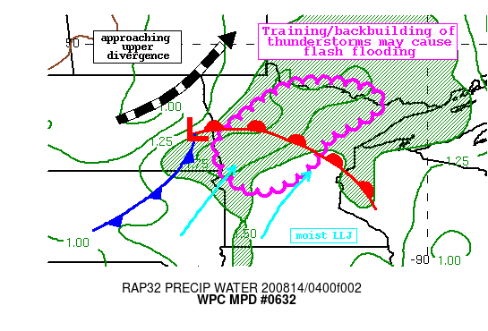
Summary...Showers and thunderstorms moving eastward ahead of a
wave of low pressure will produce torrential rain rates through
the overnight. Rainfall of 1-3" with locally higher amounts is
possible, which could lead to isolated flash flooding.

Discussion...Regional radar mosaic this morning shows a continuous
line of thunderstorms moving across parts of northwest Minnesota.
These thunderstorms are progressing eastward ahead of a wave of
low pressure analyzed in eastern ND, and along a northeastward
advancing warm front. Associated with this warm front, an 850mb
LLJ is surging moisture and instability northward, fueling the
ongoing convection, and rain rates have recently been estimated by
KMVX WSR-88D to be 2-3"/hr, although some hail contamination is
likely using higher KDP values as proxy.

As the overnight progresses, this line of thunderstorms should
persist. PWs across the area are 1.5-1.8" from recent GPS
observations, with MUCape analyzed by the RAP to be as high as
4000 J/kg across parts of SD. This moisture and instability is
being resupplied and advected northward on 850mb LLJ inflow of
20-30 kts on area VWPs, with little veering progged over the next
several hours suggesting persistence of this line. However, it is
likely that this line will begin to outpace the instability which
is much less to the east, so some weakening is possible and this
is reflected by a slow waning of HREF hourly rain rate
probabilities. At the same time though, height falls and
increasing upper level diffluence will approach from the west to
drive deep layer ascent, overcoming at least some of this loss of
instability.

Rain rates as noted above of 2+"/hr could begin to ease over the
next few hours, but should remain intense at 1-2"/hr much of the
overnight in the deepest convection. Corfidi vectors are likely to
remain significantly anti-parallel to the mean wind, suggesting
backbuilding of echoes to drive longer temporal duration of heavy
rainfall. The high-res guidance is in good agreement in a swath of
1-3" of rainfall with locally higher amounts through daybreak. In
some parts of MN, FFG is as low as 1.5"/3hrs thanks to 7-day
rainfall that has been more than 300% of normal. This implies that
even as rain rates begin to decrease, isolated flash flooding will
remain possible.

Weiss

ATTN...WFO...ABR...DLH...FGF...MPX...

ATTN...RFC...NCRFC...NWC...

LAT...LON   48759351 48679265 48529198 48269145 47849168
            47529230 47139298 46869332 46439355 45999393
            45729431 45489473 45349515 45429577 45609614
            45989645 46439668 46919660 47299629 47729576
            48129528 48559453 48709412
Last Updated: 138 AM EDT Fri Aug 14 2020
|


