| WPC Met Watch |
|
|
Mesoscale Precipitation Discussion: #0635 (2020) |
|
(Issued at 834 AM EDT Fri Aug 14 2020
) |
|
| MPD Selection |
|
|
|
|
|

Mesoscale Precipitation Discussion 0635
NWS Weather Prediction Center College Park MD
834 AM EDT Fri Aug 14 2020

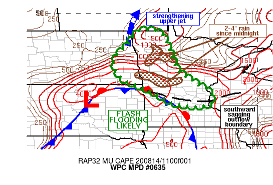
Areas affected...eastern ND into western/central MN

Concerning...Heavy rainfall...Flash flooding likely

Valid 141233Z - 141815Z

Summary...Flash flooding remains likely across portions of eastern
ND into western and central MN through 18Z. Rainfall rates of 2-3
in/hr are possible with additional storm total rainfall of 2-4
inches.

Discussion...Regional radar imagery at 12Z showed a forward
propagating cluster of thunderstorms tracking along I-94 through
central MN, oriented from northeast to southwest. KMPX rain rate
estimates with this cluster were as high as 3 in/hr near West
Union at 1130Z, and these storms have had a history of producing
rainfall rates between 2-3 in/hr. 850 mb winds ahead of an
advancing low in northern SD were estimated to be between 30 and
40 kt from the southwest (via VAD wind and RAP analysis data),
overrunning a stationary front and outflow boundary in
south-central MN. Forecast Corfidi vectors suggest the forward
propagating segment of heavy rain along I-94 will continue to
steadily advance toward the southeast over the next few hours,
possibly impacting Minneapolis-St. Paul before weakening. Despite
potential weakening, efficient rainfall production will still be
capable of rainfall rates between 1-2 in/hr.

Farther to the northwest, thunderstorms were observed to be
picking up in coverage across eastern ND, out ahead of a potent
shortwave trough advancing across the Dakotas. Large MUCAPE values
were estimated to be in place over southeastern ND, near and just
north of the stationary front with values between 2000 and 3000
J/kg. Lift ahead of the advancing upper trough is strong, with
flow widely diffluent in the upper levels as well as forecasts for
a strengthening upper level jet streak to align from eastern ND
into southern Manitoba, placing the ND/MN border within the
divergent right entrance region through 18Z. Thunderstorms should
continue to increase in coverage as the surface low over SD
advances northeastward through 18Z. While these storms are
expected to be largely progressive, brief training of intense
rainfall is likely, with rainfall rates between 2-3 in/hr at
times. Flash flood guidance across the Red River Valley is only
1-2 inches in 3 hours, so flash flooding appears likely there, as
well as if heavy rain overlaps portions of MN that received at
least 2-4 inches of rain since midnight.

Otto

ATTN...WFO...ABR...DLH...FGF...MPX...

ATTN...RFC...MBRFC...NCRFC...NWC...

LAT...LON   49049635 49019578 48799548 48079513 47399488
            46839467 46449426 46159376 45919349 45589277
            44909267 44709341 44889480 45109526 45729633
            46139747 46629801 47189818 47649802 48089746
            48729704 48969682
Last Updated: 834 AM EDT Fri Aug 14 2020
|


