| WPC Met Watch |
|
|
Mesoscale Precipitation Discussion: #0673 (2023) |
|
(Issued at 929 AM EDT Sun Jul 09 2023
) |
|
| MPD Selection |
|
|
|
|
|

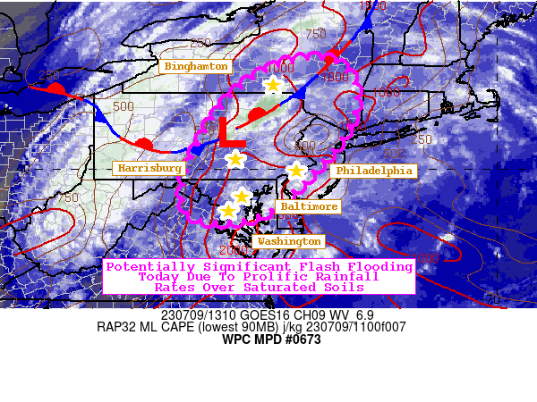
Mesoscale Precipitation Discussion 0673
NWS Weather Prediction Center College Park MD
929 AM EDT Sun Jul 09 2023

Areas affected...Northern Mid-Atlantic

Concerning...Heavy rainfall...Flash flooding likely

Valid 091330Z - 091840Z

SUMMARY...An unusually strong upper trough for mid-July coinciding
with copious amounts of moisture and sufficient instability will
result in areas of flash flooding this today. Some cases of flash
flooding could be significant with areas sporting more saturated
soils most at-risk.

DISCUSSION...An impressive synoptic-scale setup for mid-July is
unfolding at the same time as a moisture-loaded and increasingly
unstable atmosphere takes shape. Excellent upper level divergence
aloft, aided by a sharp 500-250mb trough tracking into the central
Appalachians, will foster exceptional vertical motion in the
atmospheric column today. Meanwhile, a stationary front has
already acted as a trigger for morning thunderstorms in central
PA. The 12Z IAD sounding is already primed with around 1,000
MLCAPE, PWATs of 1.71", low level RH values >80%, an a warm cloud
layer a little over 11,000ft deep. The 12Z WAL sounding, sampling
an airmass that will be advected north later today, sported 2.10
PWATs and a warm cloud layer over 13,000ft deep. As daytime
heating increases and southerly 850mb moisture transport picks up,
MLCAPE will range between 1,000-2,000 J/kg with the higher values
farther south. PWATs will also rise to 1.8-2.0", the highest of
which will reside from the Delaware Valley on south to the
northern DelMarVa. RAP forecasts also suggests warm cloud layers
will grow to as much as 12,000-14,000ft deep by mid-afternoon.

The complex interactions of the wind flow and available
moisture/instability will determine where the heaviest rainfall
sets up. One area of concern is northeast MD, northern DE, and the
Lower Susquehanna Valley where southerly 850mb flow off the
Chesapeake Bay can give rise to a convergence axis in these areas.
Speaking of the southerly 850mb flow, it is also ideal for upslope
enhancement as far north as the Poconos, northern NJ, and Lehigh
Valley. The aforementioned front in central PA and into NY is
oriented quasi-parallel to the mean 850-500mb streamlines,
supporting not just training convection but backbuilding cells as
well. Lastly, there's a large area of heavily urbanized cities at
risk, and these areas not only have a greater concentration of
hydrophobic surfaces, but many have also seen 300-400% of normal
rainfall over the last 7-14 days.

These ingredients mixed together lay the groundwork for flash
flooding on a larger scale. The 06Z HREF depicted >50%
probabilities for 6-hr FFG exceedance between 18-00Z, culminating
with 60-80% probabilities in northwest NJ and to the east of
Binghamton. These probabilities are similar to the HREF's odds of
6-hr QPF > 10-yr ARI, and there are even some 20-40% probabilities
for 6-hr QPF > 100-yr ARI in northern NJ and into south-central
NY. In the hardest hit areas, water rises in poor drainage areas,
along roadways, and along creeks and streams can occur very
quickly and pose a larger threat to life and property.

Mullinax

ATTN...WFO...ALY...BGM...CTP...LWX...OKX...PHI...

ATTN...RFC...MARFC...NERFC...NWC...

LAT...LON   42897479 42467383 41047391 38957591 38687768
            39237820 40477786 41697711 42497615
Last Updated: 929 AM EDT Sun Jul 09 2023
|


