| WPC Met Watch |
|
|
Mesoscale Precipitation Discussion: #0679 (2023) |
|
(Issued at 239 PM EDT Sun Jul 9 2023
) |
|
| MPD Selection |
|
|
|
|
|

Mesoscale Precipitation Discussion 679
NWS Weather Prediction Center College Park MD
239 PM EDT Sun Jul 9 2023

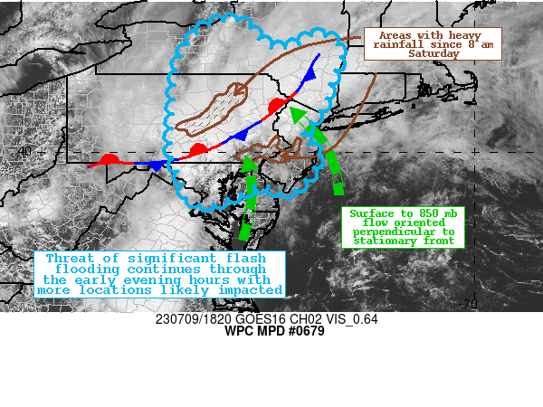
Areas affected...Central MD...Northern DE...Eastern PA...New
Jersey...Southern NY

Concerning...Heavy rainfall...Flash flooding likely

Valid 091838Z - 100030Z

SUMMARY...Impressive mid-summer synoptic scale set-up for
significant flooding is in place across northern portions of the
Mid-Atlantic region.  Repeated rounds of back-building and
training convective cells will likely lead to additional instances
of flooding, with the potential for major flash flooding.

DISCUSSION...Regional Doppler radars along with recent infrared
satellite scans are depicting a steady increase in slow moving
convection in the general vicinity of a stalled frontal boundary.
The overall environment is quite conducive for additional heavy
rainfall in the outlook area with PWs approaching 2 inches per
recent SPC mesoanalysis, and mixed layer CAPE generally on the
order of 1500-2000 J/kg, mainly in response to anomalous low-mid
70s surface dewpoints advecting northward into the region.  The
surface to 850 mb flow is generally oriented orthogonal to the
stalled front, which is acting as a corridor of enhanced ascent
with repeated rounds of back-building cells with high rainfall
rates exceeding 1 inch in 20 minutes in some instances.  The upper
level environment is also quite conducive for deep layer ascent
with strong right entrance jet dynamics and resulting divergence
at 300 mb.

The latest CAM guidance suite is depicting the potential for
patchy 3 to 5 inch QPF maxima through 8 pm tonight.  The highest
rainfall rates are likely to be associated with back-building
cells close to the front where 2-3 inches may fall within an hour,
with the greatest prospects for this generally between the greater
Baltimore metro area northeastward to White Plains, New York,
where HREF neighborhood probabilities of 3-hourly flash flood
guidance exceedance are up to 50%.  It is also important to note
that parts of this region have experienced over 300% of normal
rainfall over the past week, and part of the Delaware River Valley
had excessive rainfall yesterday along with parts of interior
eastern Pennsylvania.  Flash flooding is considered likely owing
to both the antecedent conditions and the impressive
meteorological environment.

Hamrick

ATTN...WFO...ALY...BGM...BUF...CTP...LWX...OKX...PHI...

ATTN...RFC...MARFC...NERFC...NWC...

LAT...LON   43387607 43207578 42947557 42767543 42667507
            42807450 42997429 43027398 42957371 42767353
            42497343 42077361 41637378 41317384 41007405
            40707429 40397449 40247435 40127423 39977402
            39667411 39327435 38997468 38957499 39157551
            38887615 38677679 38697733 38817743 39367758
            39747780 40457784 42097769 42897733 43357670
Last Updated: 239 PM EDT Sun Jul 09 2023
|


