| WPC Met Watch |
|
|
Mesoscale Precipitation Discussion: #0740 (2018) |
|
(Issued at 200 PM EDT Fri Aug 31 2018
) |
|
| MPD Selection |
|
|
|
|
|

Mesoscale Precipitation Discussion 0740...Corrected
NWS Weather Prediction Center College Park MD
200 PM EDT Fri Aug 31 2018

Corrected for a change from KDOV to KDOX in the 3rd paragraph

Areas affected...northern/eastern MD, eastern PA into NJ/DE

Concerning...Heavy rainfall...Flash flooding possible

Valid 311739Z - 312335Z

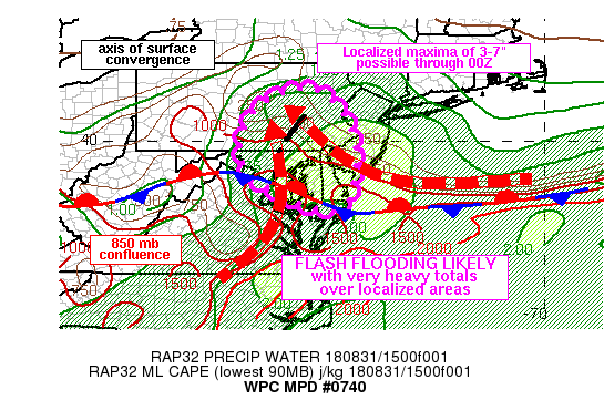
Summary...Continued localized heavy rainfall maxima from 3 up to 7
inches through 00Z expected for portions of the northern
Mid-Atlantic region. While flash flooding is not expected to be
widespread, localized thunderstorms with highly efficient rainfall
will likely lead to flash flooding.

Discussion...17Z surface observations placed a wavy east-west
oriented stationary front stretching from the southern DelMarVa
Peninsula into northern VA and central WV. To the north, an area
of surface convergence was noted between BWI and FDK, extending
north-northeastward into east-central PA, just east of I-81,
co-located with a broken line of showers/thunderstorms producing
highly efficient rainfall rates with radar estimates of 2-3 in/hr,
but with ground truth supporting 3-4 in/hr in eastern Howard
county, MD and Lebanon county in PA over the past couple of hours.

Recent area GPS sites showed precipitable water values between 1.8
and 2.1 inches along with 500-1500 J/kg MLCAPE over the northern
Mid-Atlantic region. 925 mb easterly flow of 15-20 kt was noted in
the KDIX and KDOX VAD wind profiles, with RAP analyses showing an
area of confluent 925-850 mb flow focusing across northern MD into
eastern PA helping to support lift near the surface.

Short term forecasts from the RAP show this area of confluent low
level flow relaxing a bit and then refocusing over eastern PA over
the next 3-6 hours. Hi-Res models have shown a consistent signal
for very heavy rainfall, with some of the better performing models
indicating a few localized maxima of 4-8 inches through 00Z from
the Chesapeake Bay region into eastern PA, but with poor agreement
with the finer scale details/locations. Therefore, given the
history of these rainfall cores so far through early afternoon,
more of the same is expected over the next few hours with small
scale heavy rainfall cores of 2-4 in/hr possibly leading to
localized maxima of 3-7 inches through 00Z.

Otto

ATTN...WFO...AKQ...BGM...CTP...LWX...PHI...

ATTN...RFC...MARFC...

LAT...LON   41327594 40567511 39497486 38457505 38237567
            38527655 39157761 40117780 41037714
Last Updated: 200 PM EDT Fri Aug 31 2018
|


