| WPC Met Watch |
|
|
Mesoscale Precipitation Discussion: #0842 (2023) |
|
(Issued at 838 PM EDT Wed Aug 02 2023
) |
|
| MPD Selection |
|
|
|
|
|

Mesoscale Precipitation Discussion 0842
NWS Weather Prediction Center College Park MD
838 PM EDT Wed Aug 02 2023

Areas affected...Central & Eastern MO...Southern IL

Concerning...Heavy rainfall...Flash flooding likely

Valid 030040Z - 030630Z

SUMMARY...Widespread thunderstorms developing this evening will
train and back-build over parts of the Middle MS Valley overnight.
Flash flooding is expected tonight with some areas seeing likely
to see significant impacts that include flooded roadways.

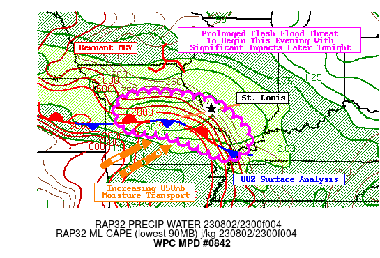
DISCUSSION...00Z surface analysis showed a frontal boundary that
was positioned over central KS and extended east towards the MS-OH
River Confluence. The air-mass is particularly hot and steamy to
the south and west of the front with dew points in the upper 70s
in parts of south-central MO. Farther north, a remnant MCV
spiraling over southern IA is responsible for an ongoing cluster
of showers and storms over central IL and southeast IA. As the sun
sets, 850mb winds over the south-central Plains and Ozarks will
accelerate, leading to increased 850mb theta-e advection directly
into the frontal boundary. 23Z RAP forecast shows the fetch of
southwesterly 850mb moisture transport will only strengthen
heading into the overnight hours.

There is no shortage of moisture and instability available for
developing thunderstorms to generate prolific rainfall rates
tonight. As much as 2,000-3,000 J/kg of MLCAPE will be present
within the warm sector to the SW of the front. In terms of
moisture, PWs will be between 2.0-2.5" over central MO and into
southern IL. PWs of this magnitude are uncommon in the Middle MS
Valley, as evidence by 12Z NAEFS depicting the PWs present are
above the 99th climatological percentile at 00Z and 06Z tonight.
Warm cloud layers will also be in excess of 12,000' deep in most
cases. Vertical wind shear will only compound the threat for
excessive rainfall. 12Z HREF showed a large increase in 0-1km SRH
>200 m2/s2 in south-central MO after 00Z, which combined with
0-6km wind shear between 35-50 knots allows storms to develop
mesocyclones and sustain them for long periods of time. Hourly
rainfall rates above 3" is likely in the most intense cells, with
2" totals falling in as little as 30 minutes also possible.

This setup gives rise to organized clusters of rotating
thunderstorms following along the frontal boundary and/or the
surface trough located near the St. Louis metro area. The 18Z HREF
shows a bulls-eye of 50-80% probabilities for 3-hr QPF to surpass
3-hr FFGs between 00-03Z this evening. The 18Z HREF continues to
highlight areas just west of St. Louis for the best odds of flash
flooding 03-06Z. This swath of excessive rainfall will stretch as
far south and east as the MS-OH Confluence. Areas just west of St.
Louis already dealt with flash flooding earlier this morning. Due
to the recent CAMs beginning to show the core of heaviest rainfall
shifting more into central MO where 3-hr FFGs are as low as 1.5"
in some cases, this supported, in collaboration with PAH/LSX/EAX,
the upgrade in the ERO to a High Risk this evening. In conclusion,
this is likely to be the first in a series of MPDs highlighting
the flash flood threat in the mid-MS Valley tonight. Note that the
bulk of the flash flooding is likely to occur well after sunset,
making flooded roads considerably more difficult to identify.

Mullinax

ATTN...WFO...EAX...LSX...PAH...SGF...

ATTN...RFC...LMRFC...MBRFC...NCRFC...OHRFC...NWC...

LAT...LON   39419265 39169071 38788981 37588871 36808950
            37259084 37779222 38039377 39019404
Last Updated: 838 PM EDT Wed Aug 02 2023
|


