| WPC Met Watch |
|
|
Mesoscale Precipitation Discussion: #0846 (2023) |
|
(Issued at 624 AM EDT Thu Aug 03 2023
) |
|
| MPD Selection |
|
|
|
|
|

Mesoscale Precipitation Discussion 0846
NWS Weather Prediction Center College Park MD
624 AM EDT Thu Aug 03 2023

Areas affected...central and southeastern MO into central KY/TN

Concerning...Heavy rainfall...Flash flooding likely

Valid 031023Z - 031500Z

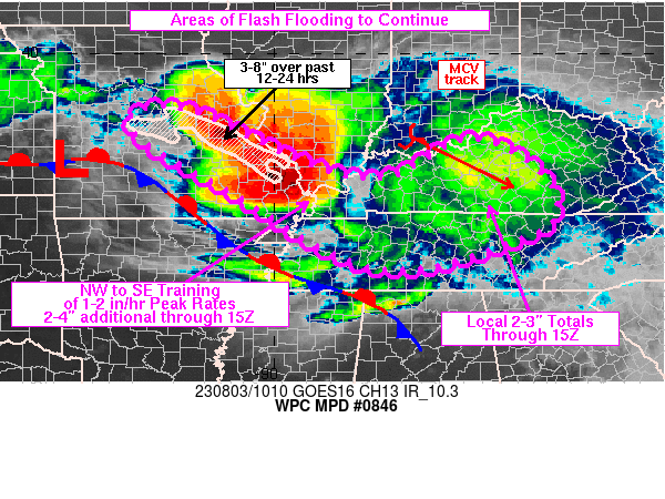
Summary...Areas of heavy rain and flash flooding are likely to
continue from portions of central and southeastern MO into western
KY through 15Z. Farther east, possible flash flooding will exist
for portions of central KY/TN. Additional totals of 2-4 inches are
expected.

Discussion...10Z regional radar imagery continued to show an axis
of training heavy rain over central and southeastern MO, although
the axis is no longer contiguous. Rainfall rates have ranged from
1-3 in/hr across this region of MO since 06Z and portions of the
region have seen 3 to 8 inches of rain over the past 24 hours
(MRMS estimates). Farther east, a well-defined MCV was located in
southern IN, tracking toward the southeast, associated with a
small region of 1-2 in/hr rainfall rates ~30 miles south of
Louisville, KY along I-65. VAD wind plots at 850 mb from KSGF and
KPAH showed 35-40 kt from the west and tied with some of the
coldest cloud tops on IR imagery. However, overrunning low level
flow and areas of confluence were still producing thunderstorms
upstream across central MO where some of the heaviest rain has
fallen over the past 6-12 hours. Precipitable water values were
estimated to be between 2 and 2.4 inches and instability ranged
from a few hundred J/kg in central KY to 1000 to 2000+ J/kg near
the confluence of the OH and MO rivers.

The focus for the heaviest rain over the next 3-5 hours is
expected to set up from southeastern MO into far southern IL and
western KY, in line with the strongest isentropic lift atop a
surface front draped across the central MO/AR border. Areas of NW
to SE training with 1-2 in/hr rates (perhaps locally higher) are
expected to continue areas of flash flooding. Farther upstream,
ascent is expected to diminish over the next few hours, however, a
localized flash flood threat will remain across central MO where
ground conditions are hyper sensitive due to recent heavy rainfall.

Locations farther east from KY into TN, ahead of the MCV, will see
a localized flash flood threat where lift ahead of the MCV will
continue areas of heavy rain with brief training just downstream
of the MCV center. The greatest limiting factor for excessive
rainfall across central KY/TN will be weak instability. However,
peak rainfall rates of 1-2 in/hr may still be enough to support
localized rainfall totals of 2-3 inches through 15Z.

Otto

ATTN...WFO...EAX...JKL...LMK...LSX...MEG...MRX...OHX...PAH...
SGF...

ATTN...RFC...LMRFC...MBRFC...NCRFC...OHRFC...NWC...

LAT...LON   38809182 38199048 37758952 37478873 37348821
            37348770 37498725 38138612 38128551 37818483
            37348425 36908404 36388417 36108477 35828556
            35528656 35448764 35608834 36088934 36949067
            37859232 38349296 38789291
Last Updated: 624 AM EDT Thu Aug 03 2023
|


