| WPC Met Watch |
|
|
Mesoscale Precipitation Discussion: #0849 (2021) |
|
(Issued at 244 PM EDT Sat Aug 21 2021
) |
|
| MPD Selection |
|
|
|
|
|

Mesoscale Precipitation Discussion 0849
NWS Weather Prediction Center College Park MD
244 PM EDT Sat Aug 21 2021

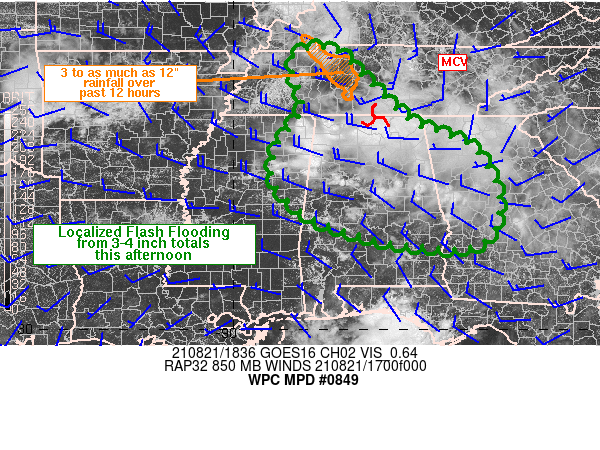
Areas affected...portions of the TN Valley into MS/AL/GA

Concerning...Heavy rainfall...Flash flooding possible

Valid 211844Z - 220015Z

SUMMARY...Peak rainfall rates of 2-3 in/hr are expected across
parts of the TN Valley into MS/AL/GA. Brief training of these
heavy rates may support localized flash flooding through the
afternoon.

DISCUSSION...Regional radar and GOES East visible satellite
imagery showed a remnant convective complex tracking SSE into
northern AL as of 18Z, with a weak MCV noted near the TN/AL
border. Convective coverage was increasing along the northern
MS/AL border within a moist and unstable environment where the 18Z
SPC mesoanalysis showed PWATs of 2.1 to 2.3 inches and MLCAPE of
1500-2500 J/kg across MS/AL. Enhanced westerly 850 mb winds near
20 kt were located from southern TN into northern MS/AL as this
region was located between low level ridging along the central
Gulf Coast and the base of an 850 mb low in western KY.

While an overall progression of storms toward the southeast is
expected this afternoon, following the deeper layer mean flow, the
relatively stronger corridor of 850 mb winds may support some
brief areas of WNW-ESE training. The moist environment combined
with ample instability should be enough to support rainfall rates
of 2-3 in/hr and where cell training occurs, a quick 3-4 inches of
rain will be possible.

In addition, recent runs of the HRRR have been supporting the
renewal of convection across parts of west-portions of the TN
Valley into MS/AL/GA between 21-00Z, ahead of a mid-level impulse
currently tracking over MO/IL. 3-12" of rain, and as high as 16
inches according to MRMS estimates over the past 12 hours,
affected west-central TN earlier this morning which has left the
region vulnerable to runoff from additional heavy rainfall. While
the area is currently stabilized in the wake of the morning
convection, there may be enough time to allow for sufficient
heating and removal of CIN to support a second round of heavy rain
within the moist environment late this afternoon/early evening.

Otto

ATTN...WFO...BMX...FFC...HUN...JAN...MEG...OHX...TAE...

ATTN...RFC...LMRFC...OHRFC...SERFC...NWC...

LAT...LON   36568771 35928700 34918593 34558509 34238439
            33358387 32428388 31928449 32068639 32598812
            33458905 34368892 35208837 36328863
Last Updated: 244 PM EDT Sat Aug 21 2021
|


