| WPC Met Watch |
|
|
Mesoscale Precipitation Discussion: #0873 (2018) |
|
(Issued at 153 PM EDT Fri Sep 21 2018
) |
|
| MPD Selection |
|
|
|
|
|

Mesoscale Precipitation Discussion 0873
NWS Weather Prediction Center College Park MD
153 PM EDT Fri Sep 21 2018

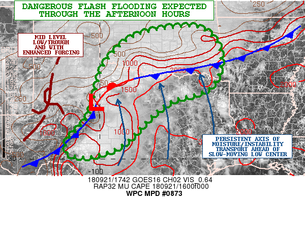
Areas affected...Central/Northern TX...Central/Southern OK

Concerning...Heavy rainfall...Flash flooding likely

Valid 211753Z - 212353Z

Summary...Dangerous flash flooding will become likely as a result
of very heavy showers and thunderstorms persisting through the
afternoon hours, with rainfall rates of as much as 3 inches/hr.

Discussion...The latest GOES-16 satellite imagery shows a
well-defined mid-level closed low center across west TX which is
advancing very slowly off to the east. This energy is interacting
with an extremely moist and at least moderately unstable airmass
pooled up across the southern Plains and particularly up against a
rather strong baroclinic zone. In fact, the latest surface
analysis depicts a cold front dropping slowly south down toward
the lower MS Valley but extending back to just north of the Red
River over southern OK and then southwest down into west TX where
there is a well-defined area of low pressure.

PWATs out ahead of the low center are highly tropical in nature
with values of 2.0 to 2.25 inches as per the latest Blended-TPW
product and also GPS-derived data sets. Meanwhile, a rather strong
instability gradient is in place along the front, with MUCAPE
values as high as 2000 j/kg pooled up near the Red River. The
combination of both will lead to extremely heavy rainfall rates
that will be as much as 3 inches/hr within the stronger convective
cores.

On the larger scale, there is excellent large scale forcing, with
right-entrance region jet dynamics in place, robust isentropic
ascent along and north of the front, and persistent deep layer
southerly flow which is maintaining the transport of very
favorable thermodynamics.

Given these ingredients, all signs continue to point to a longer
duration and high impact flash flood event across especially areas
of southern OK and northern TX. Already as much as 9 inches of
rain has been reported over Pontotoc county, OK in the vicinity of
Fittstown.

Over the next several hours, there will be a tendency for more
convection to begin focusing just south of the Red River over
northern TX, but expect very heavy rains to continue over southern
OK where dangerous flash flooding is already occurring. The latest
12Z HREF model consensus and recent HRRR guidance favors as much
as an additional 4 to 6+ inches of rain through late afternoon.

Expect life-threatening and dangerous flash flooding to occur this
afternoon across southern OK. Areas of northern TX will also
become increasingly susceptible and should be closely monitored
for excessive rainfall as well going through the mid to late
afternoon hours.

Orrison

ATTN...WFO...EWX...FWD...LUB...OUN...SHV...SJT...TSA...

ATTN...RFC...ABRFC...LMRFC...WGRFC...

LAT...LON   36079574 35639486 35039453 34259447 33529473
            33059537 32749654 32009761 30679895 30170026
            30140113 30380157 30900140 31830057 32790022
            34159986 35289893 35819780
Last Updated: 149 PM EDT Fri Sep 21 2018
|


