| WPC Met Watch |
|
|
Mesoscale Precipitation Discussion: #0923 (2021) |
|
(Issued at 113 PM EDT Wed Sep 01 2021
) |
|
| MPD Selection |
|
|
|
|
|

Mesoscale Precipitation Discussion 0923
NWS Weather Prediction Center College Park MD
113 PM EDT Wed Sep 01 2021

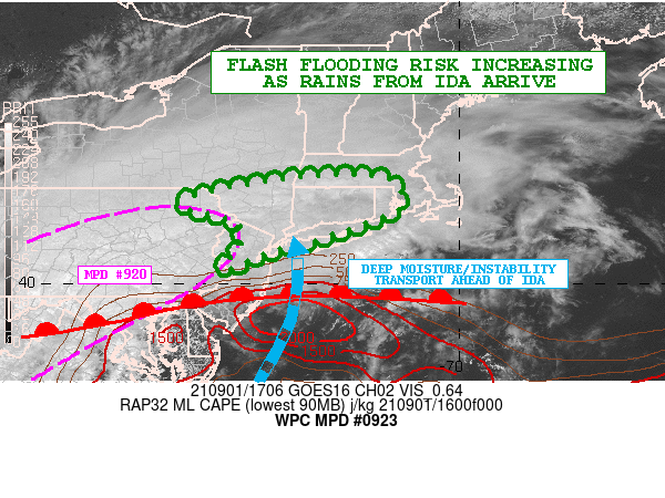
Areas affected...Portions of the Northern Mid-Atlantic...Southeast
NY and Southern New England

Concerning...Heavy rainfall...Flash flooding likely

Valid 011712Z - 011930Z

SUMMARY...Heavy rainfall overspreading areas of far northeast PA,
southeast NY, northern NJ and southern New England will increasing
in intensity over the next few hours, with areas of flash flooding
becoming increasingly likely with time.

DISCUSSION...The latest satellite and radar imagery indicates an
expansive area of steady moderate to heavy rain along with some
embedded stronger convective elements impacting areas of far
northeast PA, northern NJ, southeast NY and southern New England.
All of this activity is associated with what is now Post-T.C. Ida.

Very strong frontogenetical forcing and moisture transport is
lifting up across these areas, and with time there will be a
notable increase in the pooling of diurnally aided instability
along a warm front over the central Mid-Atlantic region that will
be advancing northeast toward southern New England going through
the afternoon hours. This will be aided largely by a strengthening
south-southwest low-level jet ahead of Ida's extratropical low
center.

Over the next few hours, there will an increase in the rainfall
intensity and coverage, and the expectation is that there will be
more numerous pockets of locally concentrated convection with very
heavy rainfall rates.

Expect some hourly rainfall rates to begin to approach 2
inches/hour locally, and given the locally heavy rain that has
occurred over the last few hours, some areas of flash flooding
will be gradually likely heading toward the mid to late-afternoon
hours.

Additional heavy rain and much more significant concerns for flash
flooding is expected to evolve by early this evening and heading
into the overnight period. Additional MPDs will be forthcoming
accordingly to address this evolvng threat as Ida approaches the
region.

Orrison

ATTN...WFO...ALY...BGM...BOX...OKX...PHI...

ATTN...RFC...MARFC...NERFC...NWC...

LAT...LON   42247162 41707122 41437157 40967289 40637408
            40217512 40757462 41237463 41397493 41717592
            42217361
Last Updated: 113 PM EDT Wed Sep 01 2021
|


