| WPC Met Watch |
|
|
Mesoscale Precipitation Discussion: #0227 (2025) |
|
(Issued at 635 PM EDT Mon May 05 2025
) |
|
| MPD Selection |
|
|
|
|
|

Mesoscale Precipitation Discussion 0227
NWS Weather Prediction Center College Park MD
635 PM EDT Mon May 05 2025

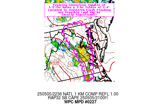
Areas affected...portions of eastern VA into the DMV and far
eastern WV

Concerning...Heavy rainfall...Flash flooding possible

Valid 052235Z - 060300Z

Summary...Training convection will be capable of hourly totals of
1-3" with short-term (3-hr) totals as high as 2-4". Isolated to
scattered instances of flash flooding are possible (and may be
locally significant in sensitive urban/mountainous terrain).

Discussion...Radar and GOES-East satellite imagery indicate the
proliferation of convection across portions of eastern VA/NC over
the past several hours, moving fairly rapidly (~25 kts) towards
the N-NE within nearly unidirectional flow on the eastern
periphery of a large, deep layer (850-200 mb) closed low centered
over IL/IN/KY. The mesoscale environment in the vicinity and
downstream of the aforementioned convection is characterized by
SBCAPE of 1000-2000 J/kg, PWATs of 0.8-1.3" (between the 75th and
90th percentile, per IAD sounding climatology), and deep layer
(0-6km shear) of 20-40 kts (per 22z SPC SFCOA analysis). The
strongest cells have been capable of impressive instantaneous
rainfall rates of 3-5"/hr (per MRMS estimates), which has resulted
in estimated hourly rainfall totals of up to 2.5" (where deeper
convective cells have been able to occasionally train, mainly to
the east of I-95 in eastern VA).

Recent hi-res CAMs have not handled the evolution of convection
particularly well, and recent observational trends (including
continued overshooting/cooling cloud tops via GOES-East imagery)
suggest that localized hourly totals of 1-3" will continue to
manifest farther north (into the more sensitive DMV region) with
storm propagation (as a pool of 1500-2000 J/kg of SBCAPE remains
untapped). While both of the hourly updating CAMs (HRRR/RRFS) are
handling the convection poorly, the 18z HREF suite does still give
a good idea of the potential for excessive rainfall through 03z
(with 40-km neighborhood probabilities for 2" and 3" exceedance of
20-30% and ~10%, respectively). Given locally sensitive terrain
(per FFGs as low as 0.75-1.50" and 1.50-2.50" for 1-hr and 3-hr
periods, respectively) over urbanized terrain along and near I-95
and over portions of the Appalachians in the vicinity of northern
VA, western MD, and far eastern WV, isolated to scattered
instances of flash flooding are possible (and may be locally
significant, should 2-4" totals occur over the most sensitive
localities).

Churchill

ATTN...WFO...AKQ...CTP...LWX...RAH...

ATTN...RFC...MARFC...SERFC...NWC...

LAT...LON   39827743 39597667 39037647 37767669 36447699
            36217739 36777738 37437742 38277778 39617833
Download in GIS format: Shapefile
| KML
Last Updated: 638 PM EDT Mon May 05 2025
|


