| WPC Met Watch |
|
|
Mesoscale Precipitation Discussion: #0224 |
|
(Issued at 319 AM EDT Mon May 05 2025
) |
|
| MPD Selection |
|
|
|
|
|

Mesoscale Precipitation Discussion 0224
NWS Weather Prediction Center College Park MD
319 AM EDT Mon May 05 2025

Areas affected...Northern & Eastern New Mexico...

Concerning...Heavy rainfall...Flash flooding possible

Valid 050720Z - 051300Z

SUMMARY...Continued risk of regenerative thunderstorms along the
dryline/surface front.  Deep layer steering may support
training/repeating locally for streaks of 2-3" totals and possible

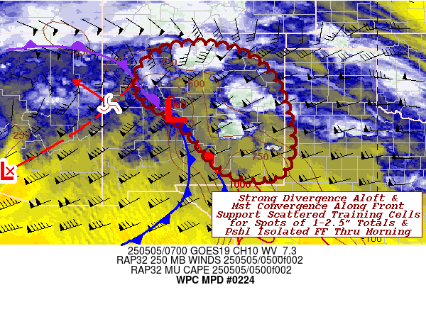
DISCUSSION...GOES WV suite depicts very deep (3-3.5 Std. Dev.)
closed low generally centered in the Lower Colorado River Valley
and is currently reorienting as very strong shortwave energy
rotates around the western to southwestern edge of current center.
 This is elongating the overall low favorably across eastern AZ
into much of NM to support strong divergent/diffluence pattern
with 100-120kt jet streak rounding the base of the upper-low in NW
Old Mexico.  In also supporting/broadening updraft strength for
any convection that does develop, it is has be strengthening solid
moisture return through the Rio Grande and Pecos Valley through
the southern High Plains.  Strong easterly and confluent
southeastern flow at 15-20kts exist across much of north-central
to southeast NM.

CIRA LPW denotes deepest moisture remains upstream across the
western TX panhandle through the Guadeloupe Mtns with nose of
.5-.75" sfc-850mb wedge trying to filter in. Concurrently, the
850-700mb layer from the southeast on 35-40kts of flow (per VWP)
is reaching .5"...reaching near 1" totals across southeast NM.
EML's are steepening lapse rates to support sufficient lapse rates
to support 500-1000 MUCAPE pooling along the stationary frontal
boundary toward a surface low in the northern Rio Grande Valley
north of ONM.  As such, orographic ascent and localized
convergence is sparking widely scattered thunderstorms in the
vicinity of the frontal zone.  Weak isallobaric pressure falls aid
inflow/maintenance of updrafts for a few hours to over-come the
strong effective bulk shear in the weakly unstable environment.
As such, steering flow in diffluent pattern supports short-term
training of the updrafts oriented more south to north across
northern NM, while more SW to NE in the vicinity of the Sacramento
Range into eastern NM.  Rates of .75"/hr and 1-2 hours of
repeating, may support localized totals of 1.5-2.5" and given
dry/hard ground conditions has the potential to exceed the lower
FFG values (1-1.5"/hr, 1-2.5"/3hrs).

Eventually, shortwave energy will round the base and the
associated jet will increase southwesterly flow and the frontal
zone will start to lift east and northeast with further enhanced
moisture flux convergence along the leading edge.  This should
help to expand overall coverage, but may limit the increased
duration locally into the early morning hours.  Isolated incidents
of flash flooding remain possible through morning.

Gallina

ATTN...WFO...ABQ...EPZ...LUB...MAF...

ATTN...RFC...ABRFC...CBRFC...WGRFC...NWC...

LAT...LON   36580528 36200420 35510344 34880312 33440283
            32370321 32280446 32710530 33670611 34260672
            34810764 35550787 36190745 36580654
Download in GIS format: Shapefile
| KML
Last Updated: 319 AM EDT Mon May 05 2025
|


