Extended Forecast Discussion
NWS Weather Prediction Center College Park MD
323 AM EDT Wed Sep 23 2026

Valid 12Z Sat Sep 26 2026 - 12Z Wed Sep 30 2026


...Impactful coastal storm meanders near the northern Mid-
Atlantic/Northeast through the weekend...


...Overview...

An upper low will stall atop the Mid-Atlantic and Northeast into
the weekend and early next week, supporting a meandering coastal
surface low. This pattern will lead to strong/gusty onshore winds
for multiple days, leading to coastal flooding, rip currents and
high surf, and potential beach erosion. An upper ridge persisting
in the south- central U.S. will promote warm temperatures while a
shallow trough moves through the north-central U.S. over the
weekend. Upstream, a deeper trough will reach the West Coast Sunday
and move through the western and central U.S. early to midweek,
spreading ample moisture and precipitation chances ahead of it.


...Guidance/Predictability Assessment...

Recent model guidance continues to show a reasonably good handle
on the large scale pattern, but with uncertainty in the details
that could impact sensible weather. First, the placement of the
Atlantic low remains questionable from day to day, impacting wind
speed/direction and how much rain falls onshore vs. offshore. The
recent 00Z guidance is slightly more agreeable, as the ECMWF
shifted east, not so tucked in near Long Island on Sunday than its
previous run. The 00Z ECMWF and CMC are pretty close together with
the track now, while the AIGFS and GFS are a bit farther north, and
the EC-AIFS a bit west. Another interesting trend has been a
weaker low than previous forecasts, as most models and ensemble
members no longer ever show a central pressure in the 980s. In any
case, the low should be weakening by Monday-Tuesday and generally
looks to pull away from the Northeast on Tuesday.

Meanwhile, an upper ridge will stretch northward across the
Mississippi Valley and Great Lakes Saturday. A shortwave looks to
pass from the north-central Plains to the Ohio Valley Sunday and
could break apart the ridge, with an upper high center contributing
to the initially blocky pattern in the Great Lakes/southeast
Canada. Ridging should rebuild in the south-central Plains Sunday-
Monday. This all shows fairly good model agreement, though varying
positions of weak fronts and precipitation potential cause
uncertainties in the temperatures. Farther west, a longwave trough
is forecast to reach the West Coast Sunday and move through the
West early next week and the central U.S. Tuesday-Wednesday. Recent
guidance is mostly agreeable that the trough should stay phased as
it moves east, so model spread is not too large for its timing
tracking east. The pattern could stay progressive as yet another
trough could reach the Northwest late period. The ECMWF seems
somewhat fast with this trough, moving through the northern Rockies
midweek while other models and ensembles are back near the Pacific
Northwest. Another feature to note is Hurricane Polo, which will
be monitored for its potential moisture connection into the
Southwest and beyond next week. After backing off a day ago and
keeping Polo farther west, some members do now show Polo
approaching Baja California again. See NHC for the official track.

The WPC forecast used a blend of deterministic, AI, and ensemble
mean guidance through the forecast period, with gradually
increasing proportions of the ensemble means to over half by Day 7
to lessen individual model differences.


...Weather/Hazards Highlights...

The meandering surface low in the western Atlantic will lead to
broad onshore flow across the Mid-Atlantic and Northeast for
multiple days. This persistent pattern could lead to coastal
flooding and beach erosion concerns, especially when combined with
high astronomical tides. Exact placement of the surface low from
day to day and thus any heavy rain is more uncertain. The latest
forecast continues to offer support that coastal New England may
see heavy rainfall into the weekend. However, stay tuned for
forecast updates, as small shifts in the low track would lead to
significant forecast shifts in rainfall amounts. See WPC's Key
Messages for this coastal low for further information.

Rain chances are forecast across the Upper/Middle Mississippi
Valley into the central Plains on Saturday, with light to moderate
amounts. The northern Plains and the Middle/Lower Mississippi
Valley could see some rain into Sunday. Meanwhile, Pacific moisture
should make a return ahead of the large-scale trough in the West,
bringing some rain to the Four Corners states northward Sunday.
Precipitation is forecast to become more widespread Monday,
stretching into much of the Plains to Upper Midwest, and tracking
east to reach the Mississippi Valley on Tuesday. Rain could be
heavy in some areas but the details will have to be refined in
future forecasts. Some snow is possible in the higher peaks of the
Intermountain West/Rockies with the precipitation, as the trough
aloft helps to cool temperatures.

Warmer than average temperatures will persist in the south-central
U.S. into the weekend and early next week under the upper ridge,
and highs in the 90s are forecast through the southern Plains and
Lower Mississippi Valley. A round of slightly above average
temperatures may push through the north-central U.S. as well. On
the other hand, cooler than average temperatures (especially for
highs) are forecast for the Northwest under troughing aloft,
gradually spreading eastward into the Interior West early next week
and helping to moderate temperatures in the Plains by midweek.


Tate


Additional 3-7 Day Hazard information can be found on the WPC
medium range hazards outlook chart at:
https://www.wpc.ncep.noaa.gov/threats/threats.php

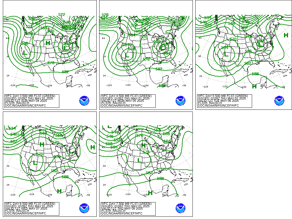
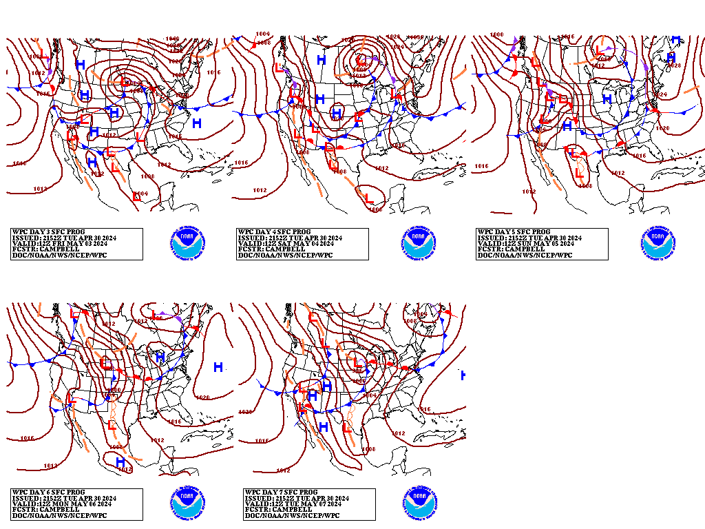
WPC medium range 500mb heights, surface systems, weather grids,
quantitative precipitation forecast, excessive rainfall outlook,
winter weather outlook probabilities, heat indices and Key Messages
are at:

https://www.wpc.ncep.noaa.gov/medr/5dayfcst500_wbg.gif
https://www.wpc.ncep.noaa.gov/medr/5dayfcst_wbg_conus.gif
https://www.wpc.ncep.noaa.gov/5km_grids/5km_gridsbody.html
https://www.wpc.ncep.noaa.gov/qpf/day4-7.shtml
https://www.wpc.ncep.noaa.gov/#page=ero
https://www.wpc.ncep.noaa.gov/wwd/pwpf_d47/pwpf_medr.php?day=4
https://www.wpc.ncep.noaa.gov/heat_index.shtml
https://www.wpc.ncep.noaa.gov/#page=ovw
 weather.gov