


202607181220260718002026071800
Valid Sat Jul 18, 2026
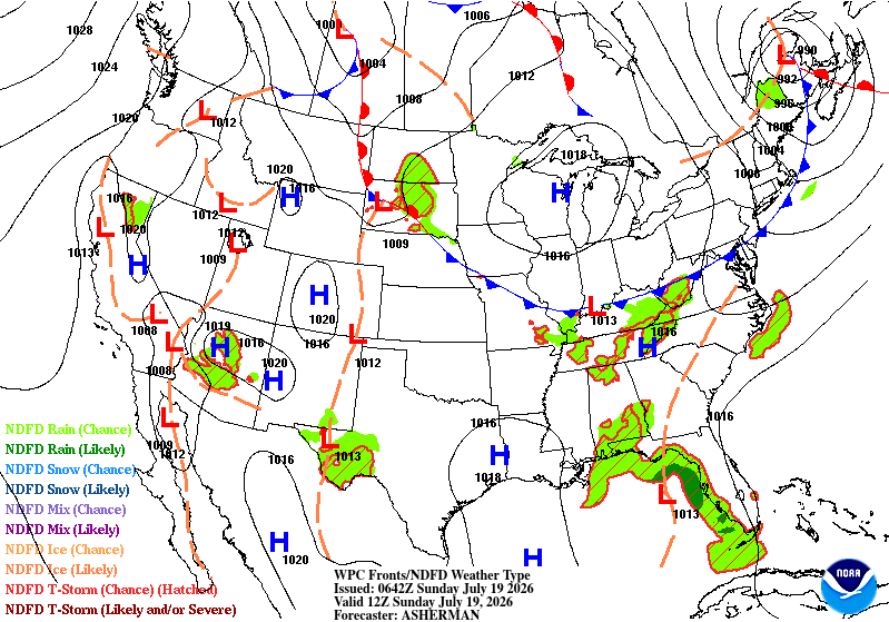
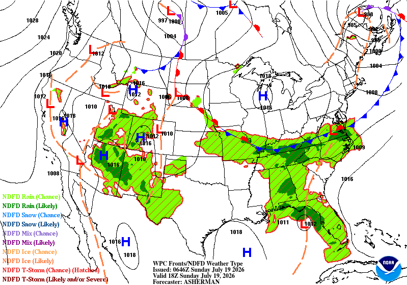
Valid Sun Jul 19, 2026
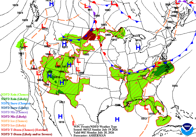
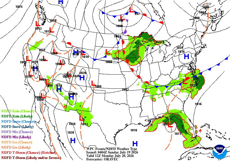
Valid Mon Jul 20, 2026


Mesoscale Precipitation Discussion #0777 is currently in effect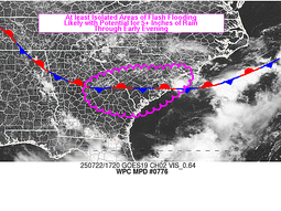
Mesoscale Precipitation Discussion #0776 is currently in effect
Latest Key Messages for Southern U.S. Heat Wave
We are interested in feedback about our Precipitation Object Tracking page!
Check out the HeatRisk page to understand potential heat impacts.
Explore WPC's experimental Probabilistic Precipitation Portal
National Forecast Chart
Valid Sat Jul 18, 2026
Valid Sun Jul 19, 2026
Valid Mon Jul 20, 2026
Image Format:
» Interactive National Forecast Chart
+ Additional Links
+ Additional Links
- » Description of the National Forecast Chart
- » Product Archives
- » Download hazards in KML or shapefile format or GeoJSON format
WPC Top Stories:
Mesoscale Precipitation Discussion #0777 is currently in effect
Mesoscale Precipitation Discussion #0776 is currently in effect
Latest Key Messages for Southern U.S. Heat Wave
We are interested in feedback about our Precipitation Object Tracking page!
Check out the HeatRisk page to understand potential heat impacts.
Explore WPC's experimental Probabilistic Precipitation Portal
North American Surface Analysis Legacy Page:
Analyzed at 03Z Sat Jul 18, 2026
Analyzed at 06Z Sat Jul 18, 2026
Analyzed at 09Z Sat Jul 18, 2026
Analyzed at 12Z Sat Jul 18, 2026
Analyzed at 15Z Sat Jul 18, 2026
Analyzed at 18Z Sat Jul 18, 2026
Analyzed at 21Z Sat Jul 18, 2026
Analyzed at 00Z Sun Jul 19, 2026
Analyzed at 03Z Sun Jul 19, 2026
Image Format:


Surface Fronts and Sea-Level Pressures Legacy Page:
Analyzed 03Z Sun Jul 19, 2026
Valid 12Z Sun Jul 19, 2026
Valid 18Z Sun Jul 19, 2026
Valid 00Z Mon Jul 20, 2026
Valid 12Z Mon Jul 20, 2026
Valid 00Z Tue Jul 21, 2026
Valid 12Z Tue Jul 21, 2026
Valid 12Z Wed Jul 22, 2026
Valid 12Z Thu Jul 23, 2026
Valid 12Z Fri Jul 24, 2026
Valid 12Z Sat Jul 25, 2026


+ Short Range Forecast Discussion (Day ½-2½)
+ Medium Range Forecast Discussion (Day 3-7)
+ Additional Links
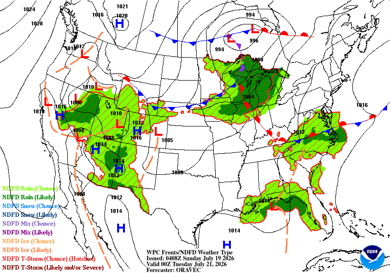
Short Range Forecast Discussion
NWS Weather Prediction Center College Park MD
300 PM EDT Sat Jul 18 2026

Valid 00Z Sun Jul 19 2026 - 00Z Tue Jul 21 2026

...Additional Canadian wildfire smoke to move south across the
Great Lakes into the Mid-West, while improvements to air quality
expected across the East...

...Active thunderstorms expected along and ahead of a cold front
pressing south along the east coast...

...An active monsoonal precip pattern to continue over the next
few days from the Southwest into the Great Basin...

...System over the northeast Gulf may bring heavy rains to coastal
sections of the eastern Gulf...

...Major heat risks build from the Northern Plains into the Lower
Mississippi Valley...

The ongoing wildfires across western portions of Ontario will
continue to be a source of wildfire smoke affecting portions of
the CONUS this weekend into next.  The next batch of smoke is
expected to push southward from the Great Lakes into the Mid-West
this weekend/early next week.  Air quality alerts are currently in
effect across these area and eastward into the Northeast and New
England.  While smoke concentrations are expected to increase over
the next few days over the Great Lakes to Mid-West areas, there is
expected to be a decrease in smoke concentrations from the
Mid-Atlantic into the Northeast/New England as the current region
of smoke pushes northeastward and off the coast Saturday night
into early Sunday.  While additional smoke is forecast to sink
south and southeast Sunday and Monday across these areas, the
concentration of smoke is not expected to be as bad as the
recent/current event.

The lead area of smoke affecting the East on Saturday will be
shunted northeastward by a southeastward moving cold front late
Saturday into early Sunday.  Thunderstorms have already become
active along and ahead of this front Saturday afternoon across the
northeast and will likely continue Saturday evening from southern
New England, south through the Mid-Atlantic.  These thunderstorms
will pose the risk of heavy rains, localized flash flooding and
severe weather.  Active thunderstorms along and ahead of this
front will then affect the southern Mid-Atlantic into the Southern
Appalachians Sunday afternoon into Sunday evening, with heavy
rains, isolated flash flooding and severe weather.

Relatively quiet weather expected over areas of Texas hit hard
from recent very rains.  Locally heavy rains are possible,
however. over far Southwest Texas where above average moisture
values are expected.  These above average moisture values will
also extend farther to the northwest, across the Southwest and
into the Great Basin.  This will support a continuation of an
active monsoonal precipitation pattern across these areas.
Locally heavy rains and isolated flash flooding are possible
across these regions for this weekend and extending into the
beginning to middle parts of the upcoming week.

Across the northeast Gulf, an slow moving system may bring heavy
rains to coastal sections of the eastern Gulf over the next few
days.  Please see the latest National Hurricane Center's Tropical
Weather Outlook for additional information on this system.

Temperature wise, major heat risks will be increasing Sunday and
Monday from the Northern Plains, southeastward into the Lower
Missouri and Lower Mississippi Valleys.  Much above average
temperatures expected across these areas with highs ranging from
the Mid 90s to Lower 100s.


Oravec

Graphics available at
https://www.wpc.ncep.noaa.gov/basicwx/basicwx_ndfd.php
Extended Forecast Discussion
NWS Weather Prediction Center College Park MD
125 PM EDT Sat Jul 18 2026

Valid 12Z Tue Jul 21 2026 - 12Z Sat Jul 25 2026


...Hazardous Heat to settle down across the South next week...


...Overview...

Very hot and moist conditions will focus over the South next week
as northern tier shortwaves and moderating surface fronts focus
rounds of locally heavy rains and strong to severe thunderstorms
from the Midwest/Great Lakes to the East. Lead activity over the
South/Southeast may be fueled by Gulf/tropical moisture. Elsewhere,
ample monsoonal moisture will continue to stream from the
Southwest and Intermountain West/Rockies and then the Plains to
fuel enhanced showers and thunderstorms as a closed upper high
shifts to the southern Plains. Meanwhile, current Tropical Storm
Elida is forecast by NHC to weaken into next week while lifting
northward well off the West Coast near 130W as a maritime threat.

...Guidance/Predictability Assessment...

Guidance remains in generally good agreement through the early
portion of the period, with deterministic solutions from the GFS,
ECMWF, and CMC depicting a broadly similar large-scale synoptic
pattern of a ridge building over the West and South and a troughing
over the East. The models also capture the shortwave energy
progressing through the northern tier and southern Canada, with
some minor differences with timing and amplitude. Differences begin
towards mid to late week, where the amplitude, timing, and phasing
of shortwaves embedded within the northern stream become larger.
Additionally, models diverge with the deepening of the trough over
the eastern U.S. and over Pacific Northwest, specifically with the
ECMWF. These differences translate into frontal placement across
central and eastern U.S., which can impact precipitation timing
and magnitude. The ensemble means seems to smooth some of these
differences a bit, especially after Wednesday. Therefore, the
forecast favored a multi-model blend for the first portion of the
period, with phasing in the ensemble means towards the latter
portion of the period.


...Weather/Hazards Highlights...

Flow around a main upper ridge will continue to draw significant
monsoonal moisture into the Southwest and Intermountain
West/Rockies into next week. This moisture will lead to scattered
to numerous showers and thunderstorms with potential to produce
heavy rainfall and localized flash flooding. Sensitive places such
as burn scars, steep terrain, etc., would be the most vulnerable to
any flooding concerns that may develop. Broad Marginal and an
embedded Slight Risk of excessive rainfall have been introduced
from the Southwest into the Intermountain West for Tuesday into
Wednesday. Shower and thunderstorm coverage should gradually
increase eastward from the Rockies into the Plains next week as the
closed upper high shifts down to the southern Plains.

Upper ridge/closed high influence shift to the south will lead to
at least Major HeatRisks over much of the South next week as
temperatures 5-10F above already hot averages combine with high
humidity. Expect spotty record highs and more widespread record
overnight lows. Heat indices may rise to 105-110+F in some spots.

Elsewhere, heavy rains with strong to severe thunderstorms per SPC
are forecast to work through the Midwest/Great Lakes into early
next week given shortwaves aloft and wavy frontal push. As the
upper trough position amplifies and the fronts work southeast
through early-mid next week, heavy convective rain chances will
overspread much of the East, settling into the Southeast later next
week with slow wavy frontal progression. WPC Excessive Rainfall
Marginal Risk areas slowly shift eastward Tuesday and Wednesday
from the Ohio Valley to over the Mid-Atlantic and the Northeast.
An embedded Slight Risk area has also been introduced for Tuesday
over the central Appalachians.

Meanwhile to the South, energy is forecast to meander from the
northeastern Gulf in a moist and unstable environment into early
next week as monitored by NHC. Troughing and tropical moisture in
place (even if there is no true tropical low) may lead to heavy
rain and Marginal Risks are from northern Florida to the coastal
Southeast for isolated flash flooding for Tuesday into Wednesday.
There is some guidance signal to monitor that a combination of
system energies from the north and deeper Gulf/tropical moisture
may favor lingering heavy rain frontal focus extending into later
next week over the eastern Carolinas versus a shift just offshore.


Oudit/Schichtel


Additional 3-7 Day Hazard information can be found on the WPC
medium range hazards outlook chart at:
https://www.wpc.ncep.noaa.gov/threats/threats.php

WPC medium range 500mb heights, surface systems, weather grids,
quantitative precipitation forecast, excessive rainfall outlook,
winter weather outlook probabilities, heat indices and Key Messages
are at:

https://www.wpc.ncep.noaa.gov/medr/5dayfcst500_wbg.gif
https://www.wpc.ncep.noaa.gov/medr/5dayfcst_wbg_conus.gif
https://www.wpc.ncep.noaa.gov/5km_grids/5km_gridsbody.html
https://www.wpc.ncep.noaa.gov/qpf/day4-7.shtml
https://www.wpc.ncep.noaa.gov/#page=ero
https://www.wpc.ncep.noaa.gov/wwd/pwpf_d47/pwpf_medr.php?day=4
https://www.wpc.ncep.noaa.gov/heat_index.shtml
https://www.wpc.ncep.noaa.gov/#page=ovw
Quantitative Precipitation Forecasts Legacy Page:
Valid 12Z 07/22/2026 - 12Z 07/23/2026
Valid 12Z 07/23/2026 - 12Z 07/24/2026
Valid 12Z 07/24/2026 - 12Z 07/25/2026
Valid 12Z 07/25/2026 - 12Z 07/26/2026
Valid 06Z 07/19/2026 - 18Z 07/19/2026
Valid 12Z 07/19/2026 - 00Z 07/20/2026
Valid 18Z 07/19/2026 - 06Z 07/20/2026
Valid 00Z 07/20/2026 - 12Z 07/20/2026
Valid 06Z 07/20/2026 - 18Z 07/20/2026
Valid 12Z 07/20/2026 - 00Z 07/21/2026
Valid 18Z 07/20/2026 - 06Z 07/21/2026
Valid 00Z 07/21/2026 - 12Z 07/21/2026
Valid 06Z 07/21/2026 - 18Z 07/21/2026
Valid 12Z 07/21/2026 - 00Z 07/22/2026
Valid 18Z 07/21/2026 - 06Z 07/22/2026
Valid 00Z 07/22/2026 - 12Z 07/22/2026


» View
Probabilistic Precipitation Guidance (Day 1-3)
» Extreme Precipitation Monitor
+ Additional Links
» Extreme Precipitation Monitor
+ Additional Links
- » Product Verification
- » Product Archive
- » Product Info
- » Additional formats of QPF: GRIB 2 | Shapefiles | KML
- » Other QPF Products
Excessive Rainfall Forecasts Legacy Page:
Valid 01Z Sun Jul 19 2026 - 12Z Sun Jul 19 2026
Valid 12Z Sun Jul 19 2026 - 12Z Mon Jul 20 2026
Valid 12Z Mon Jul 20 2026 - 12Z Tue Jul 21 2026
Valid 12Z Sun Jul 19 2026 - 12Z Mon Jul 20 2026
Valid 12Z Mon Jul 20 2026 - 12Z Tue Jul 21 2026


+ Forecast Discussion
Excessive Rainfall Discussion
NWS Weather Prediction Center College Park MD
856 PM EDT Sat Jul 18 2026
Day 1
Valid 01Z Sun Jul 19 2026 - 12Z Sun Jul 19 2026
...THERE IS A SLIGHT RISK OF EXCESSIVE RAINFALL FROM PORTIONS OF
WEST TEXAS THROUGH THE EASTERN GREAT BASIN, AS WELL AS PARTS OF THE
NORTHEAST AND MID-ATLANTIC...
01Z Update...
The late day ramp up of convective coverage and rainfall intensity
in the western United States will continue through the evening and
into the overnight hours within a monsoonal flow pattern. Some
minor expansions of the Slight Risk area were made to better fit
the afternoon radar trends...but the greatest coverage of intense
rainfall rates were generally confined to the southern tier of
states and this well handled by the previous forecast.
In the eastern United States...one round of convection from earlier
in the day has pretty well run its course and had either weakened
or moved off-shore. However...additional convection being forced a
cold front making its way through the Ohio Valley and Northeast
into parts of New York...Pennsylvania and the Mid-Atlantic region
has the potential to renew flooding or worsen on-going flooding in
areas primed by earlier rainfall. As a result...main changes were
to remove outlook area that were post-frontal but largely left
areas in tact that were pre-frontal.
Bann
Previous Discussion...
...Western Texas to the Four Corners/Great Basin...
Monsoon ridge will become favorably aligned to draw impressive
thermodynamics northward from Mexico, reaching from West Texas
through much of the Desert Southwest and then northward into the
Great Basin and Intermountain West. Multiple weak shortwaves
embedded within the flow will continue to progress anti-
cyclonically around this ridge, bringing locally enhanced ascent
to the region, with a few of these impulses noted on morning WV
imagery in TX and NM. While any of these impulses will locally
enhance ascent leading to clusters of more organized convection
today, the greatest risk is just the breadth of coverage of
thunderstorms with potentially heavy rainfall today.
PWs this morning are impressive across the region, measured via GPS
and morning RAOBs vary from around 1.2 inches at SLC to as high as
2.1 inches at PHX, at or above the 90th percentile across a large
area (and as high as +3 sigma), and that measured PW at PHX this
morning is a daily record. At the same time instability is progged
to climb to 1000-2000 J/kg, locally even higher, as far as 40N
latitude in the Four Corners, which is impressive and is a typical
discriminator of more widespread monsoonal heavy rain/flash flood
days.
THe CAMs, including the UA WRF, are aggressive with coverage of
their simulated reflectivity across much of the area today, with
hourly rainfall potentially reaching 1.5 to 2.5 inches. This could
easily exceed the 1-hr FFG across the region, and in some areas the
3-hr FFG even has a high chance (40-60%) of being exceeded where
terrain-tying or boundary-collisions can cause a temporal extension
of the heavy rain rates. With storm motions generally expected to
be weak at 5-10 kts and chaotic, an active day is expected, with
scattered flash flooding expected, especially across vulnerable
features like burn scars, slot canyons, and urban areas.
The inherited SLGT risk was modified to account for recent
guidance, and there was some consideration of an increased risk
based on the impressive REFS exceedance probabilities which rise
above 55% for FFG, but the more muted HREF was used more heavily,
especially since the highest FFG exceedance is across the higher
elevations of the Mogollon Rim and not down into the deserts
(although an expansion SW into some lower terrain was made with
this update).
...Midwest to the Mid Atlantic and Northeast...
A cold front will drop steadily southeast from the Great Lakes,
reaching the lower Ohio Valley and the Mid-Atlantic by Sunday
morning. Ahead of this front, impressive moisture will pool from
Kentucky eastward to Long Island and Cape Cod, where PWs are
already 1.75 to 2.0 inches and will climb above 2.0 inches through
this aftn. The overlap of this elevated PW with increasing SBCAPE
(2000-3000 J/kg forecast) will create robust thermodynamics which
will support widespread convection capable of producing intense
hourly rainfall for which the HREF and REFS suggest has a 40-60%
(10-15% chance) of exceeding 1 inch (2 inches).
The excessive rainfall risk will steadily increase through the aftn
and continue into this evening/tonight as multiple rounds of
thunderstorms develop and track across the area. 0-6km bulk shear is
progged to increase to 30-40 kts ahead of the cold front, and as
weak impulses move west to east from the Ohio Valley into the Mid-
Atlantic, this will allow for some organization into clusters
tracking parallel to the front (and pre-frontal trough). Ahead of
the front, the Corfidi vectors and mean flow will align from the
west, leading to an increased backbuilding potential into the
higher thermodynamics with cells then tracking across the same
areas of the Mid-Atlantic states and into southern New England.
This will occur ahead of the front which will produce a second
round of heavy rainfall potential, albeit with more progressive NW
to SE motion to the cells.
The inherited SLGT risk has been adjusted to account for new
guidance, and due to elevated probabilities from both the HREF and
REFS (40-60% for 3"/24hrs, 10-15% for 5"/24hrs) atop sensitive
areas due to urban development and recent rainfall producing compromised
FFG. This included connecting the SLGT risks across PA where the
ARW guidance is most aggressive and there is sufficient potential
for some training (or meso-cyclones to enhance rainfall rates) to
include a larger area. Considered an elevated internal SLGT risk
for the Tri-State area as well, but enough uncertainty in position
and timing of redevelopment after CAPE exhaustion this morning
prevented that category increase.
...Florida Panhandle through Southwest Georgia...
Deep moisture spreading north ahead of a slow-moving mid-to-upper
level low will pool along a surface trough extending out of the
eastern Gulf. This moisture (PWs increasing to above 2 inches)
will fuel slow-moving storms as Corfidi vectors become aligned
anti-parallel to weak 0-6km mean winds of just 5-10 kts. With rain
rates possibly (20-40%) exceeding 2"/hr at times this could create
at least isolated instances of excessive rainfall leading to flash
flooding.
...Western Florida Peninsula...
A convective MCV positioned west of the Florida Panhandle across
the northeast Gulf will drift westward today within a pool of
tropical PWs nearing 2.25 inches. As this feature drifts slowly
westward, it has, at least this morning, temporarily stalled inflow
along the Florida west coast between Naples and Fort Meyers. The
high-res CAMs are not extremely aggressive with rainfall today,
but have been under-forecasting the current activity (MRMS already
2-4" in some areas with hourly rain rates of 2-3"). If this band
continues to stall, continued impressive rainfall rates are likely,
and the recent RRFS, HRRR, and some of the experimental REFS
members show an additional 2-4" of rain are possible. This has
resulted in a narrow MRGL risk addition which aligns well with
recently issued MPD #764.
Weiss
Day 1 threat area: www.wpc.ncep.noaa.gov/qpf/94epoints.txt
Excessive Rainfall Discussion
NWS Weather Prediction Center College Park MD
856 PM EDT Sat Jul 18 2026
Day 2
Valid 12Z Sun Jul 19 2026 - 12Z Mon Jul 20 2026
...THERE IS A SLIGHT RISK OF EXCESSIVE RAINFALL OVER PORTIONS THE
SOUTHWESTERN U.S. FROM WEST TEXAS TO SOUTHERN UTAH, AS WELL AS
PORTIONS OF NORTH CAROLINA...
...Southwestern U.S....
The monsoon ridge will persist in a favorable alignment Sunday,
keeping the overall synoptic pattern relatively unchanged from D1.
This will create another day of scattered to widespread convection
from the Desert Southwest, through West Texas, and northward into
the Great Basin and Intermountain West. The primary different
between the synoptic pattern Saturday vs Sunday may be just a
subtle reorganization of the ridge center near the WY/CO border,
which could allow for a subtly farther NW shift of thunderstorm
activity than what occurs Saturday.
Regardless, the environment will support another active day, and
with PWs reaching +2 to +3 sigma (a plume of 0.75" north to 1.75"
south) overlapping widespread MUCAPE of 250-1000 J/kg, this will
support heavy rainfall rates within any of the convection on
Sunday. HREF and REFS neighborhood probabilities indicate a 60-80%
chance of hourly rainfall to 1", with locally 2"/hr rates also
possible (10-20%). Although bulk shear is expected to remain
modest, up to 20 kts, suggesting primarily pulse type convection,
weak 0-6km mean winds and Corfidi vectors will allow for storm
mergers and boundary interactions to cause chaotic and slow
motions, with subtle terrain tying or boundary stalling storms
developing at times. This will create locally 3-4" of rain,
especially from the Mogollon Rim southeast into West Texas where
higher MUCAPE is progged. However, anywhere these slow storms
develop with the intense rain rates, instances of flash flooding
will be possible, especially atop sensitive terrain features like
slot canyons and dry washes, or over burn scars and urban areas.
Once again, the probabilities indicate the heaviest rainfall will
occur in the higher terrain, but light E/NE flow and outflows could
help storms dive off the terrain into the lower deserts at times as
well.
...Mid-Mississippi Valley through the Carolinas...
After coordination with the eastern NC WFOs, a targeted SLGT risk
has been added for eastern NC embedded within the broader MRGL
extending from the Mid-Mississippi Valley through the Tennessee
Valley and into the southern Mid-Atlanic states. This area will see
scattered to widespread thunderstorm development along and ahead of
a cold front which will slowly drop southward through the day. The
downstream environment will be extremely supportive of heavy rain
thanks to PWs of 2-2.25 inches overlapped with MUCAPE above 2000
J/kg.
While much of the convection will be of the pulse variety, some
increasing bulk shear reaching 25-35 kts, especially late across NC
and the Mid-Mississippi Valley could help organize storms into
clusters, which will then move parallel to the boundary to support
prolonged periods of training. With rainfall rates of 2"/hr or
more, this could cause locally more than 3" of rain, with a 20-40%
chance of at least 5" across eastern NC where a shortwave will help
spawn a wave of low pressure to improve ascent and organize
thunderstorm activity.
...Eastern Gulf Coast...
A tropical disturbance (AL91) for which NHC has a 40% of
development over the next 7 days in the northeastern Gulf will
spread at least moderate rainfall onshore the west coast of Florida
through the Panhandle and potentially as far east as eastern
Louisiana. While there is considerable uncertainty into the onshore
extent of QPF on D2, the HREF and REFS both suggest a 20-40% chance
of at least 3" of rainfall along the coast, driving the adjustments
to the inherited MRGL risk.
...Upper Mississippi Valley...
A shortwave embedded within squeezed mid-level flow will crest the
Four-Corners ridge and then dive southeast Sunday evening/night
into the Northern Plains and Upper Midwest. This shortwave will
interact with a frontal system to enhance ascent, with a wave of
low pressure potentially also developing. As the LLJ develops
within the accompanying warm sector, it is progged to accelerate to
25-35 kts, drawing robust thermodynamics (PWs above 2" with MUCAPE
over 3000 J/kg) northward and isentropically ascending the NW to SE
oriented warm front. This will help spawn thunderstorms during the
evening, with backbuilding/training possible from the eastern
Dakotas into southern Minnesota. The HREF and REFS probabilities
suggest a 15-25% chance for at least 3" of rainfall thanks to
training 1-2"/hr rain rates, so a MRGL risk was added for at least
localized flash flood potential.
Weiss
Day 2 threat area: www.wpc.ncep.noaa.gov/qpf/98epoints.txt
Excessive Rainfall Discussion
NWS Weather Prediction Center College Park MD
856 PM EDT Sat Jul 18 2026
Day 3
Valid 12Z Mon Jul 20 2026 - 12Z Tue Jul 21 2026
...THERE IS A SLIGHT RISK OF EXCESSIVE RAINFALL OVER PORTIONS OF
ARIZONA AND NEW MEXICO...
...Southwest...
Changes from inherited were primarily cosmetic to account for new
guidance, but another day of active (although with somewhat less
coverage than the weekend) monsoonal convection is expected. This
is due to a generally unchanged synoptic pattern with anomalous
moisture supporting convective activity and rainfall efficiency.
South of the ridge, as in the previous few days, shortwaves
rotating westward will help steer and enhance convective coverage,
and where this overlaps with the greatest instability/PW across
NM/AZ should receive the greatest coverage of thunderstorms with
flash flood potential. There is some concern that instability may
struggle to return Monday due to widespread convective coverage and
residual cloud cover Sunday night, which may necessitate
additional adjustments to the risk area, but at this time it still
appears there will be another day of scattered to widespread
convection with at least scattered flash flood instances. This will
be most likely across vulnerable features such as dry washes, burn
scars, and slot canyons.
...Great Lakes...
A well-defined shortwave interacting with deepening moisture is
expected to produce strong storms capable of producing heavy
rainfall across the region. Locally backed and accelerated low-
level flow will help surge PWs to 2 inches or more, especially
within a progressive warm sector progged to race across the region
during D3. This moisture, along with strong ascent driven both by
low-level isentropic ascent and favorable upper jet dynamics, will
fuel the potential for heavy rainfall-producing storms. Increasing
bulk shear to 30-50 kts will help organize convection into clusters
or supercells, raising the potential for intense rain rates of
1-2"/hr, through which any short-term training could enhance the
flood risk. At this time storms may move rapidly enough to preclude
a higher risk, but will continue to monitor for a possible targeted
upgrade to a SLGT risk with later issuances.
...North Carolina/Southern Virginia...
A Marginal Risk was maintained where a front and coinciding pool
of deep moisture (PWs at or above 2 inches) are expected to linger,
extending the threat for heavy rainfall and possible flash
flooding into a second day. There is some potential a SLGT risk may
be needed here as well, but that risk will be somewhat dependent on
what occurs D2, so after coordination with the WFOs, opted to
maintain the MRGL for now and reassess as the event gets closer.
...Florida Gulf Coast...
Considerable uncertainty remains regarding AL91 in the northern
Gulf. There will continue to be at least a low-end risk for heavy
rainfall around this system as tropical moisture streams northward
to the FL Panhandle and surrounding areas. At this time the MRGL
risk was maintained and only cosmetically adjusted, but future
refinements are expected as this system becomes more organized.
Weiss
Day 3 threat area: www.wpc.ncep.noaa.gov/qpf/99epoints.txt
+ Additional Links
Excessive Rainfall Discussion
NWS Weather Prediction Center College Park MD
856 PM EDT Sat Jul 18 2026
Day 1
Valid 01Z Sun Jul 19 2026 - 12Z Sun Jul 19 2026
...THERE IS A SLIGHT RISK OF EXCESSIVE RAINFALL FROM PORTIONS OF
WEST TEXAS THROUGH THE EASTERN GREAT BASIN, AS WELL AS PARTS OF THE
NORTHEAST AND MID-ATLANTIC...
01Z Update...
The late day ramp up of convective coverage and rainfall intensity
in the western United States will continue through the evening and
into the overnight hours within a monsoonal flow pattern. Some
minor expansions of the Slight Risk area were made to better fit
the afternoon radar trends...but the greatest coverage of intense
rainfall rates were generally confined to the southern tier of
states and this well handled by the previous forecast.
In the eastern United States...one round of convection from earlier
in the day has pretty well run its course and had either weakened
or moved off-shore. However...additional convection being forced a
cold front making its way through the Ohio Valley and Northeast
into parts of New York...Pennsylvania and the Mid-Atlantic region
has the potential to renew flooding or worsen on-going flooding in
areas primed by earlier rainfall. As a result...main changes were
to remove outlook area that were post-frontal but largely left
areas in tact that were pre-frontal.
Bann
Previous Discussion...
...Western Texas to the Four Corners/Great Basin...
Monsoon ridge will become favorably aligned to draw impressive
thermodynamics northward from Mexico, reaching from West Texas
through much of the Desert Southwest and then northward into the
Great Basin and Intermountain West. Multiple weak shortwaves
embedded within the flow will continue to progress anti-
cyclonically around this ridge, bringing locally enhanced ascent
to the region, with a few of these impulses noted on morning WV
imagery in TX and NM. While any of these impulses will locally
enhance ascent leading to clusters of more organized convection
today, the greatest risk is just the breadth of coverage of
thunderstorms with potentially heavy rainfall today.
PWs this morning are impressive across the region, measured via GPS
and morning RAOBs vary from around 1.2 inches at SLC to as high as
2.1 inches at PHX, at or above the 90th percentile across a large
area (and as high as +3 sigma), and that measured PW at PHX this
morning is a daily record. At the same time instability is progged
to climb to 1000-2000 J/kg, locally even higher, as far as 40N
latitude in the Four Corners, which is impressive and is a typical
discriminator of more widespread monsoonal heavy rain/flash flood
days.
THe CAMs, including the UA WRF, are aggressive with coverage of
their simulated reflectivity across much of the area today, with
hourly rainfall potentially reaching 1.5 to 2.5 inches. This could
easily exceed the 1-hr FFG across the region, and in some areas the
3-hr FFG even has a high chance (40-60%) of being exceeded where
terrain-tying or boundary-collisions can cause a temporal extension
of the heavy rain rates. With storm motions generally expected to
be weak at 5-10 kts and chaotic, an active day is expected, with
scattered flash flooding expected, especially across vulnerable
features like burn scars, slot canyons, and urban areas.
The inherited SLGT risk was modified to account for recent
guidance, and there was some consideration of an increased risk
based on the impressive REFS exceedance probabilities which rise
above 55% for FFG, but the more muted HREF was used more heavily,
especially since the highest FFG exceedance is across the higher
elevations of the Mogollon Rim and not down into the deserts
(although an expansion SW into some lower terrain was made with
this update).
...Midwest to the Mid Atlantic and Northeast...
A cold front will drop steadily southeast from the Great Lakes,
reaching the lower Ohio Valley and the Mid-Atlantic by Sunday
morning. Ahead of this front, impressive moisture will pool from
Kentucky eastward to Long Island and Cape Cod, where PWs are
already 1.75 to 2.0 inches and will climb above 2.0 inches through
this aftn. The overlap of this elevated PW with increasing SBCAPE
(2000-3000 J/kg forecast) will create robust thermodynamics which
will support widespread convection capable of producing intense
hourly rainfall for which the HREF and REFS suggest has a 40-60%
(10-15% chance) of exceeding 1 inch (2 inches).
The excessive rainfall risk will steadily increase through the aftn
and continue into this evening/tonight as multiple rounds of
thunderstorms develop and track across the area. 0-6km bulk shear is
progged to increase to 30-40 kts ahead of the cold front, and as
weak impulses move west to east from the Ohio Valley into the Mid-
Atlantic, this will allow for some organization into clusters
tracking parallel to the front (and pre-frontal trough). Ahead of
the front, the Corfidi vectors and mean flow will align from the
west, leading to an increased backbuilding potential into the
higher thermodynamics with cells then tracking across the same
areas of the Mid-Atlantic states and into southern New England.
This will occur ahead of the front which will produce a second
round of heavy rainfall potential, albeit with more progressive NW
to SE motion to the cells.
The inherited SLGT risk has been adjusted to account for new
guidance, and due to elevated probabilities from both the HREF and
REFS (40-60% for 3"/24hrs, 10-15% for 5"/24hrs) atop sensitive
areas due to urban development and recent rainfall producing compromised
FFG. This included connecting the SLGT risks across PA where the
ARW guidance is most aggressive and there is sufficient potential
for some training (or meso-cyclones to enhance rainfall rates) to
include a larger area. Considered an elevated internal SLGT risk
for the Tri-State area as well, but enough uncertainty in position
and timing of redevelopment after CAPE exhaustion this morning
prevented that category increase.
...Florida Panhandle through Southwest Georgia...
Deep moisture spreading north ahead of a slow-moving mid-to-upper
level low will pool along a surface trough extending out of the
eastern Gulf. This moisture (PWs increasing to above 2 inches)
will fuel slow-moving storms as Corfidi vectors become aligned
anti-parallel to weak 0-6km mean winds of just 5-10 kts. With rain
rates possibly (20-40%) exceeding 2"/hr at times this could create
at least isolated instances of excessive rainfall leading to flash
flooding.
...Western Florida Peninsula...
A convective MCV positioned west of the Florida Panhandle across
the northeast Gulf will drift westward today within a pool of
tropical PWs nearing 2.25 inches. As this feature drifts slowly
westward, it has, at least this morning, temporarily stalled inflow
along the Florida west coast between Naples and Fort Meyers. The
high-res CAMs are not extremely aggressive with rainfall today,
but have been under-forecasting the current activity (MRMS already
2-4" in some areas with hourly rain rates of 2-3"). If this band
continues to stall, continued impressive rainfall rates are likely,
and the recent RRFS, HRRR, and some of the experimental REFS
members show an additional 2-4" of rain are possible. This has
resulted in a narrow MRGL risk addition which aligns well with
recently issued MPD #764.
Weiss
Day 1 threat area: www.wpc.ncep.noaa.gov/qpf/94epoints.txt
Excessive Rainfall Discussion
NWS Weather Prediction Center College Park MD
856 PM EDT Sat Jul 18 2026
Day 2
Valid 12Z Sun Jul 19 2026 - 12Z Mon Jul 20 2026
...THERE IS A SLIGHT RISK OF EXCESSIVE RAINFALL OVER PORTIONS THE
SOUTHWESTERN U.S. FROM WEST TEXAS TO SOUTHERN UTAH, AS WELL AS
PORTIONS OF NORTH CAROLINA...
...Southwestern U.S....
The monsoon ridge will persist in a favorable alignment Sunday,
keeping the overall synoptic pattern relatively unchanged from D1.
This will create another day of scattered to widespread convection
from the Desert Southwest, through West Texas, and northward into
the Great Basin and Intermountain West. The primary different
between the synoptic pattern Saturday vs Sunday may be just a
subtle reorganization of the ridge center near the WY/CO border,
which could allow for a subtly farther NW shift of thunderstorm
activity than what occurs Saturday.
Regardless, the environment will support another active day, and
with PWs reaching +2 to +3 sigma (a plume of 0.75" north to 1.75"
south) overlapping widespread MUCAPE of 250-1000 J/kg, this will
support heavy rainfall rates within any of the convection on
Sunday. HREF and REFS neighborhood probabilities indicate a 60-80%
chance of hourly rainfall to 1", with locally 2"/hr rates also
possible (10-20%). Although bulk shear is expected to remain
modest, up to 20 kts, suggesting primarily pulse type convection,
weak 0-6km mean winds and Corfidi vectors will allow for storm
mergers and boundary interactions to cause chaotic and slow
motions, with subtle terrain tying or boundary stalling storms
developing at times. This will create locally 3-4" of rain,
especially from the Mogollon Rim southeast into West Texas where
higher MUCAPE is progged. However, anywhere these slow storms
develop with the intense rain rates, instances of flash flooding
will be possible, especially atop sensitive terrain features like
slot canyons and dry washes, or over burn scars and urban areas.
Once again, the probabilities indicate the heaviest rainfall will
occur in the higher terrain, but light E/NE flow and outflows could
help storms dive off the terrain into the lower deserts at times as
well.
...Mid-Mississippi Valley through the Carolinas...
After coordination with the eastern NC WFOs, a targeted SLGT risk
has been added for eastern NC embedded within the broader MRGL
extending from the Mid-Mississippi Valley through the Tennessee
Valley and into the southern Mid-Atlanic states. This area will see
scattered to widespread thunderstorm development along and ahead of
a cold front which will slowly drop southward through the day. The
downstream environment will be extremely supportive of heavy rain
thanks to PWs of 2-2.25 inches overlapped with MUCAPE above 2000
J/kg.
While much of the convection will be of the pulse variety, some
increasing bulk shear reaching 25-35 kts, especially late across NC
and the Mid-Mississippi Valley could help organize storms into
clusters, which will then move parallel to the boundary to support
prolonged periods of training. With rainfall rates of 2"/hr or
more, this could cause locally more than 3" of rain, with a 20-40%
chance of at least 5" across eastern NC where a shortwave will help
spawn a wave of low pressure to improve ascent and organize
thunderstorm activity.
...Eastern Gulf Coast...
A tropical disturbance (AL91) for which NHC has a 40% of
development over the next 7 days in the northeastern Gulf will
spread at least moderate rainfall onshore the west coast of Florida
through the Panhandle and potentially as far east as eastern
Louisiana. While there is considerable uncertainty into the onshore
extent of QPF on D2, the HREF and REFS both suggest a 20-40% chance
of at least 3" of rainfall along the coast, driving the adjustments
to the inherited MRGL risk.
...Upper Mississippi Valley...
A shortwave embedded within squeezed mid-level flow will crest the
Four-Corners ridge and then dive southeast Sunday evening/night
into the Northern Plains and Upper Midwest. This shortwave will
interact with a frontal system to enhance ascent, with a wave of
low pressure potentially also developing. As the LLJ develops
within the accompanying warm sector, it is progged to accelerate to
25-35 kts, drawing robust thermodynamics (PWs above 2" with MUCAPE
over 3000 J/kg) northward and isentropically ascending the NW to SE
oriented warm front. This will help spawn thunderstorms during the
evening, with backbuilding/training possible from the eastern
Dakotas into southern Minnesota. The HREF and REFS probabilities
suggest a 15-25% chance for at least 3" of rainfall thanks to
training 1-2"/hr rain rates, so a MRGL risk was added for at least
localized flash flood potential.
Weiss
Day 2 threat area: www.wpc.ncep.noaa.gov/qpf/98epoints.txt
Excessive Rainfall Discussion
NWS Weather Prediction Center College Park MD
856 PM EDT Sat Jul 18 2026
Day 3
Valid 12Z Mon Jul 20 2026 - 12Z Tue Jul 21 2026
...THERE IS A SLIGHT RISK OF EXCESSIVE RAINFALL OVER PORTIONS OF
ARIZONA AND NEW MEXICO...
...Southwest...
Changes from inherited were primarily cosmetic to account for new
guidance, but another day of active (although with somewhat less
coverage than the weekend) monsoonal convection is expected. This
is due to a generally unchanged synoptic pattern with anomalous
moisture supporting convective activity and rainfall efficiency.
South of the ridge, as in the previous few days, shortwaves
rotating westward will help steer and enhance convective coverage,
and where this overlaps with the greatest instability/PW across
NM/AZ should receive the greatest coverage of thunderstorms with
flash flood potential. There is some concern that instability may
struggle to return Monday due to widespread convective coverage and
residual cloud cover Sunday night, which may necessitate
additional adjustments to the risk area, but at this time it still
appears there will be another day of scattered to widespread
convection with at least scattered flash flood instances. This will
be most likely across vulnerable features such as dry washes, burn
scars, and slot canyons.
...Great Lakes...
A well-defined shortwave interacting with deepening moisture is
expected to produce strong storms capable of producing heavy
rainfall across the region. Locally backed and accelerated low-
level flow will help surge PWs to 2 inches or more, especially
within a progressive warm sector progged to race across the region
during D3. This moisture, along with strong ascent driven both by
low-level isentropic ascent and favorable upper jet dynamics, will
fuel the potential for heavy rainfall-producing storms. Increasing
bulk shear to 30-50 kts will help organize convection into clusters
or supercells, raising the potential for intense rain rates of
1-2"/hr, through which any short-term training could enhance the
flood risk. At this time storms may move rapidly enough to preclude
a higher risk, but will continue to monitor for a possible targeted
upgrade to a SLGT risk with later issuances.
...North Carolina/Southern Virginia...
A Marginal Risk was maintained where a front and coinciding pool
of deep moisture (PWs at or above 2 inches) are expected to linger,
extending the threat for heavy rainfall and possible flash
flooding into a second day. There is some potential a SLGT risk may
be needed here as well, but that risk will be somewhat dependent on
what occurs D2, so after coordination with the WFOs, opted to
maintain the MRGL for now and reassess as the event gets closer.
...Florida Gulf Coast...
Considerable uncertainty remains regarding AL91 in the northern
Gulf. There will continue to be at least a low-end risk for heavy
rainfall around this system as tropical moisture streams northward
to the FL Panhandle and surrounding areas. At this time the MRGL
risk was maintained and only cosmetically adjusted, but future
refinements are expected as this system becomes more organized.
Weiss
Day 3 threat area: www.wpc.ncep.noaa.gov/qpf/99epoints.txt
Winter Weather Forecasts Legacy Page:


» Interactive Winter Weather Map (Day 1-3)
» Interactive Winter Weather Map (Day 4-7)
+ Forecast Discussion (Day 1-3)
Probabilistic Heavy Snow and Icing Discussion
NWS Weather Prediction Center College Park MD
154 PM EDT Wed May 6 2026
Valid 00Z Thu May 07 2026 - 00Z Sun May 10 2026
...WPC Winter Weather Desk no longer routinely staffed until
late September, 2026...
Pending any significant winter weather, the WPC Winter Weather Desk
will not be staffed through the summer. The desk will resume
continuous staffing starting in the fall.
The WPC winter products will continue to be produced, however, and
all products except the heavy snow discussion (HSD) will be
available. This includes the Winter Storm Outlook (WSO), Winter
Storm Severity Index (WSSI), and Probabilistic Winter Precipitation
Forecasts (PWPF).
WPC
+ Additional Links
» Interactive Winter Weather Map (Day 4-7)
+ Forecast Discussion (Day 1-3)
Probabilistic Heavy Snow and Icing Discussion
NWS Weather Prediction Center College Park MD
154 PM EDT Wed May 6 2026
Valid 00Z Thu May 07 2026 - 00Z Sun May 10 2026
...WPC Winter Weather Desk no longer routinely staffed until
late September, 2026...
Pending any significant winter weather, the WPC Winter Weather Desk
will not be staffed through the summer. The desk will resume
continuous staffing starting in the fall.
The WPC winter products will continue to be produced, however, and
all products except the heavy snow discussion (HSD) will be
available. This includes the Winter Storm Outlook (WSO), Winter
Storm Severity Index (WSSI), and Probabilistic Winter Precipitation
Forecasts (PWPF).
WPC
- » Product Verification
- » Product Archive
- » Product Info
- » Forecast Surface Low Positions: Uncertainty Circles | Ensemble Clusters
- » Other Winter Weather Products
Medium Range Forecasts Legacy Page:
Valid 12Z Wed Jul 22, 2026
Valid 12Z Thu Jul 23, 2026
Valid 12Z Fri Jul 24, 2026
Valid 12Z Sat Jul 25, 2026
Valid 12Z Sun Jul 26, 2026
Image Options:


+ Forecast Discussion
+ Additional Links
Extended Forecast Discussion
NWS Weather Prediction Center College Park MD
125 PM EDT Sat Jul 18 2026

Valid 12Z Tue Jul 21 2026 - 12Z Sat Jul 25 2026


...Hazardous Heat to settle down across the South next week...


...Overview...

Very hot and moist conditions will focus over the South next week
as northern tier shortwaves and moderating surface fronts focus
rounds of locally heavy rains and strong to severe thunderstorms
from the Midwest/Great Lakes to the East. Lead activity over the
South/Southeast may be fueled by Gulf/tropical moisture. Elsewhere,
ample monsoonal moisture will continue to stream from the
Southwest and Intermountain West/Rockies and then the Plains to
fuel enhanced showers and thunderstorms as a closed upper high
shifts to the southern Plains. Meanwhile, current Tropical Storm
Elida is forecast by NHC to weaken into next week while lifting
northward well off the West Coast near 130W as a maritime threat.

...Guidance/Predictability Assessment...

Guidance remains in generally good agreement through the early
portion of the period, with deterministic solutions from the GFS,
ECMWF, and CMC depicting a broadly similar large-scale synoptic
pattern of a ridge building over the West and South and a troughing
over the East. The models also capture the shortwave energy
progressing through the northern tier and southern Canada, with
some minor differences with timing and amplitude. Differences begin
towards mid to late week, where the amplitude, timing, and phasing
of shortwaves embedded within the northern stream become larger.
Additionally, models diverge with the deepening of the trough over
the eastern U.S. and over Pacific Northwest, specifically with the
ECMWF. These differences translate into frontal placement across
central and eastern U.S., which can impact precipitation timing
and magnitude. The ensemble means seems to smooth some of these
differences a bit, especially after Wednesday. Therefore, the
forecast favored a multi-model blend for the first portion of the
period, with phasing in the ensemble means towards the latter
portion of the period.


...Weather/Hazards Highlights...

Flow around a main upper ridge will continue to draw significant
monsoonal moisture into the Southwest and Intermountain
West/Rockies into next week. This moisture will lead to scattered
to numerous showers and thunderstorms with potential to produce
heavy rainfall and localized flash flooding. Sensitive places such
as burn scars, steep terrain, etc., would be the most vulnerable to
any flooding concerns that may develop. Broad Marginal and an
embedded Slight Risk of excessive rainfall have been introduced
from the Southwest into the Intermountain West for Tuesday into
Wednesday. Shower and thunderstorm coverage should gradually
increase eastward from the Rockies into the Plains next week as the
closed upper high shifts down to the southern Plains.

Upper ridge/closed high influence shift to the south will lead to
at least Major HeatRisks over much of the South next week as
temperatures 5-10F above already hot averages combine with high
humidity. Expect spotty record highs and more widespread record
overnight lows. Heat indices may rise to 105-110+F in some spots.

Elsewhere, heavy rains with strong to severe thunderstorms per SPC
are forecast to work through the Midwest/Great Lakes into early
next week given shortwaves aloft and wavy frontal push. As the
upper trough position amplifies and the fronts work southeast
through early-mid next week, heavy convective rain chances will
overspread much of the East, settling into the Southeast later next
week with slow wavy frontal progression. WPC Excessive Rainfall
Marginal Risk areas slowly shift eastward Tuesday and Wednesday
from the Ohio Valley to over the Mid-Atlantic and the Northeast.
An embedded Slight Risk area has also been introduced for Tuesday
over the central Appalachians.

Meanwhile to the South, energy is forecast to meander from the
northeastern Gulf in a moist and unstable environment into early
next week as monitored by NHC. Troughing and tropical moisture in
place (even if there is no true tropical low) may lead to heavy
rain and Marginal Risks are from northern Florida to the coastal
Southeast for isolated flash flooding for Tuesday into Wednesday.
There is some guidance signal to monitor that a combination of
system energies from the north and deeper Gulf/tropical moisture
may favor lingering heavy rain frontal focus extending into later
next week over the eastern Carolinas versus a shift just offshore.


Oudit/Schichtel


Additional 3-7 Day Hazard information can be found on the WPC
medium range hazards outlook chart at:
https://www.wpc.ncep.noaa.gov/threats/threats.php

WPC medium range 500mb heights, surface systems, weather grids,
quantitative precipitation forecast, excessive rainfall outlook,
winter weather outlook probabilities, heat indices and Key Messages
are at:

https://www.wpc.ncep.noaa.gov/medr/5dayfcst500_wbg.gif
https://www.wpc.ncep.noaa.gov/medr/5dayfcst_wbg_conus.gif
https://www.wpc.ncep.noaa.gov/5km_grids/5km_gridsbody.html
https://www.wpc.ncep.noaa.gov/qpf/day4-7.shtml
https://www.wpc.ncep.noaa.gov/#page=ero
https://www.wpc.ncep.noaa.gov/wwd/pwpf_d47/pwpf_medr.php?day=4
https://www.wpc.ncep.noaa.gov/heat_index.shtml
https://www.wpc.ncep.noaa.gov/#page=ovw
Warning: include(tools_test.php): Failed to open stream: No such file or directory in /data/public/para/para_includes/productdisplay_test.php on line 84
Warning: include(): Failed opening 'tools_test.php' for inclusion (include_path='.:/usr/share/pear:/usr/share/php') in /data/public/para/para_includes/productdisplay_test.php on line 84


